Map of Bourbon County - Bourbon County is a county located in the U.S. state of Kentucky. Bourbon County Map showing cities, highways, important places and water bodies. Get Where is Bourbon County located in the map, major cities in Bourbon county, population, areas, and places of interest.
Map of Bourbon County, Kentucky
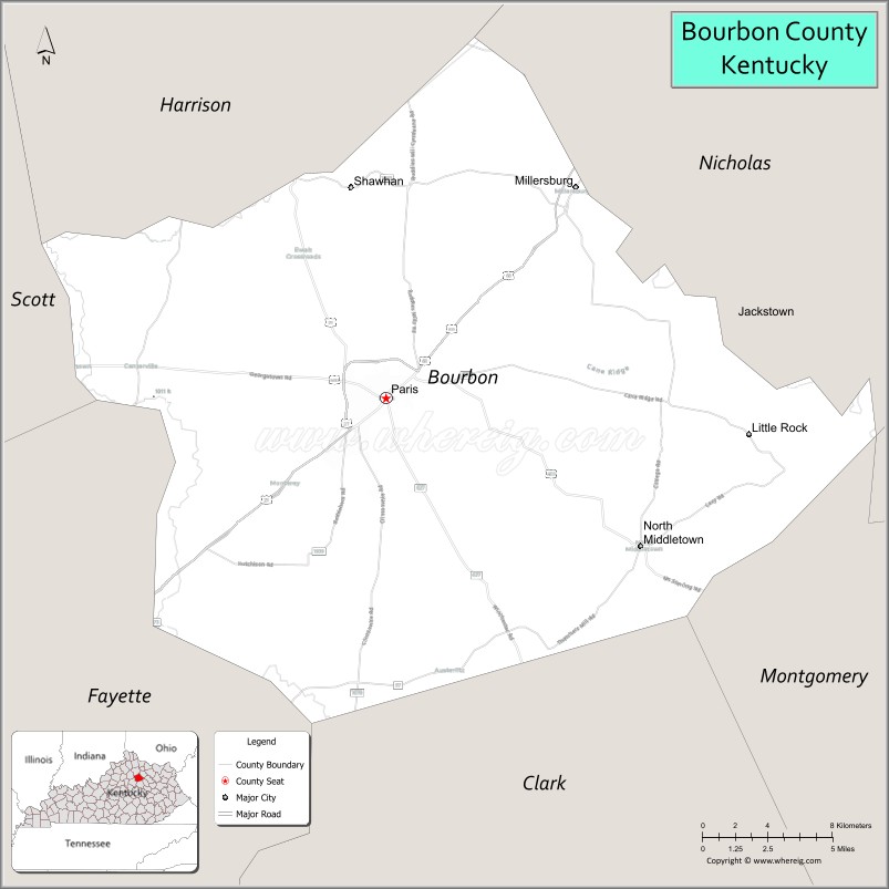
About Bourbon County Map, Kentucky: The map showing the county boundary, county seat, major cities, highways, water bodies and neighbouring counties.
More Kentucky Maps & Info
Map of Bourbon County, Kentucky
Bourbon County is a county located in the U.S. state of Kentucky. It's county seat is Paris. As per 2020 census, the population of Bourbon County is 20229 people and population density is square miles. According to the United States Census Bureau, the county has a total area of 291 sq mi (754 km2). Bourbon County was established on 1785.
Bourbon County Facts
| Continent | North America |
| Country | United States |
| State | Kentucky |
| County Seat | Paris |
| Largest City/Town | Paris |
| Established | 1785 |
| Total Area | 292 sq mi (756 sq km) |
| Land Area | 290 sq mi (751 sq km) |
| Water Area | 1.9 sq mi (5 sq km) |
| Population | 20,432 (Census 2020) |
| Population Density | 70 people per sq mi |
| Time Zone | Eastern Time Zone (ET) |
| Major Highways | U.S. Route 27, U.S. Route 68, KY Route 460, KY Route 627 |
| Major Rivers | Stoner Creek, Hinkston Creek, South Fork Licking River |
| Neighboring Counties | Fayette County, Nicholas County, Scott County, Clark County, Harrison County, Bath County |
| Famous For | Horse farms, bourbon heritage, Bluegrass landscapes, and Thoroughbred breeding |
| Top Attractions | Claiborne Farm, Downtown Paris, Hopewell Museum, Bluegrass Scenic Byways, Bourbon County Courthouse |
| Official Website | Official Website |
About Bourbon County, Kentucky
Bourbon County is located in the Bluegrass region of central Kentucky and was established in 1785, making it one of the oldest counties in the state. The county seat and largest city is Paris. Bourbon County is internationally known for horse farms, rolling Bluegrass scenery, and its historical connection to bourbon whiskey production. ([en.wikipedia.org](https://en.wikipedia.org/wiki/Bourbon_County%2C_Kentucky?utm_source=chatgpt.com))
Cities and Communities in Bourbon County, Kentucky
| City/Town | Population | Latitude & Longitude |
|---|---|---|
| Paris (county seat) | 10,171+ | 38.2098°N, 84.2527°W |
| Millersburg | 842+ | 38.3023°N, 84.1472°W |
| North Middletown | 730+ | 38.1515°N, 84.1130°W |
| Little Rock | Unincorporated | 38.2589°N, 84.2271°W |
| Ruddles Mills | Unincorporated | 38.2879°N, 84.3196°W |
| Shawhan | Historic Community | 38.1854°N, 84.1798°W |
| Clintonville | Unincorporated | 38.2627°N, 84.3864°W |
| Centerville | Unincorporated | 38.2259°N, 84.0874°W |
Best Golf Courses in Bourbon County, Kentucky
| Golf Course | Location | Latitude & Longitude |
|---|---|---|
| Houston Oaks Golf Course | Paris | 38.2027°N, 84.2478°W |
| Paris Country Club | Paris | 38.1968°N, 84.2596°W |
| Canewood Golf Course | Nearby Georgetown | 38.2139°N, 84.5710°W |
| Cherry Blossom Golf & Country Club | Nearby Georgetown | 38.2052°N, 84.5455°W |
What are Major Roads and Highways in Bourbon County
Major highways connect Bourbon County with Lexington and surrounding Bluegrass communities.
- U.S. Route 27 - north-south route linking Paris with Lexington and northern Kentucky
- U.S. Route 68 - scenic route connecting Paris with Lexington and Maysville
- KY Route 460 - regional highway serving eastern Bourbon County communities
- KY Route 627 - connector route through horse farm country and rural areas
Neighboring Counties of Bourbon County
- Fayette County (southwest)
- Nicholas County (east)
- Scott County (west)
- Clark County (south)
- Harrison County (north)
- Bath County (southeast)
What are Top Attractions in Bourbon County, Kentucky
The county is known for horse farms, historic downtown areas, and scenic Bluegrass countryside.
| Main Sight Name | City | Famous For |
|---|---|---|
| Claiborne Farm | Paris | Historic Thoroughbred horse farm and racing heritage |
| Downtown Paris | Paris | Historic buildings, local boutiques, and dining |
| Hopewell Museum | Paris | Regional history and Bluegrass heritage exhibits |
| Bourbon County Courthouse | Paris | Historic county landmark and architecture |
| Bluegrass Scenic Byways | Countywide | Horse farms and rolling countryside drives |
| Millersburg Military Institute Historic Area | Millersburg | Historic educational campus and architecture |
| Stoner Creek | Countywide | Fishing and scenic rural landscapes |
| Horse Farm Tours | Paris Area | Thoroughbred breeding and equestrian culture |
| Paris-Bourbon County Farmers Market | Paris | Local produce and Kentucky products |
| Historic Main Street Paris | Paris | Antique shops and Bluegrass small-town charm |
Distance from Bourbon County to Nearby Cities
The following distances are measured by road (driving).
- Paris to Lexington, Kentucky - 18 mi (29 km)
- Paris to Frankfort, Kentucky - 39 mi (63 km)
- Paris to Louisville, Kentucky - 88 mi (142 km)
- Paris to Winchester, Kentucky - 19 mi (31 km)
- Paris to Georgetown, Kentucky - 29 mi (47 km)
- Paris to Maysville, Kentucky - 54 mi (87 km)
- Paris to Richmond, Kentucky - 43 mi (69 km)
- Paris to Cincinnati, Ohio - 83 mi (134 km)
- Paris to Mount Sterling, Kentucky - 36 mi (58 km)
- Paris to Covington, Kentucky - 81 mi (130 km)
- Paris to Danville, Kentucky - 59 mi (95 km)
- Paris to Nashville, Tennessee - 222 mi (357 km)
References
- Bourbon County Official Website
- Bourbon County, Kentucky - Wikipedia
- U.S. Census Bureau QuickFacts
- City of Paris Official Website
- Kentucky Tourism
- Adair County Map
- Allen County Map
- Anderson County Map
- Ballard County Map
- Barren County Map
- Bath County Map
- Bell County Map
- Boone County Map
- Bourbon County Map
- Boyd County Map
- Boyle County Map
- Bracken County Map
- Breathitt County Map
- Breckinridge County Map
- Bullitt County Map
- Butler County Map
- Caldwell County Map
- Calloway County Map
- Campbell County Map
- Carlisle County Map
- Carroll County Map
- Carter County Map
- Casey County Map
- Christian County Map
- Clark County Map
- Clay County Map
- Clinton County Map
- Crittenden County Map
- Cumberland County Map
- Daviess County Map
- Edmonson County Map
- Elliott County Map
- Estill County Map
- Fayette County Map
- Fleming County Map
- Floyd County Map
- Franklin County Map
- Fulton County Map
- Gallatin County Map
- Garrard County Map
- Grant County Map
- Graves County Map
- Grayson County Map
- Green County Map
- Greenup County Map
- Hancock County Map
- Hardin County Map
- Harlan County Map
- Harrison County Map
- Hart County Map
- Henderson County Map
- Henry County Map
- Hickman County Map
- Hopkins County Map
- Jackson County Map
- Jefferson County Map
- Jessamine County Map
- Johnson County Map
- Kenton County Map
- Knott County Map
- Knox County Map
- LaRue County Map
- Laurel County Map
- Lawrence County Map
- Lee County Map
- Leslie County Map
- Letcher County Map
- Lewis County Map
- Lincoln County Map
- Livingston County Map
- Logan County Map
- Lyon County Map
- McCracken County Map
- McCreary County Map
- McLean County Map
- Madison County Map
- Magoffin County Map
- Marion County Map
- Marshall County Map
- Martin County Map
- Mason County Map
- Meade County Map
- Menifee County Map
- Mercer County Map
- Metcalfe County Map
- Monroe County Map
- Montgomery County Map
- Morgan County Map
- Muhlenberg County Map
- Nelson County Map
- Nicholas County Map
- Ohio County Map
- Oldham County Map
- Owen County Map
- Owsley County Map
- Pendleton County Map
- Perry County Map
- Pike County Map
- Powell County Map
- Pulaski County Map
- Robertson County Map
- Rockcastle County Map
- Rowan County Map
- Russell County Map
- Scott County Map
- Shelby County Map
- Simpson County Map
- Spencer County Map
- Taylor County Map
- Todd County Map
- Trigg County Map
- Trimble County Map
- Union County Map
- Warren County Map
- Washington County Map
- Wayne County Map
- Webster County Map
- Whitley County Map
- Wolfe County Map
- Woodford County Map
- Alabama Counties
- Alaska boroughs
- Arizona Counties
- Arkansas Counties
- California County Map
- Colorado Counties
- Connecticut Counties
- Delaware Counties
- Florida County Map
- Georgia County Map
- Hawaii Counties
- Idaho Counties
- Illinois Counties
- Indiana Counties
- Iowa Counties
- Kansas Counties
- Kentucky Counties
- Louisiana Counties
- Maine Counties
- Maryland Counties
- Massachusetts Counties
- Michigan County Map
- Minnesota Counties
- Mississippi Counties
- Missouri Counties
- Montana Counties
- Nebraska Counties
- Nevada Counties
- New York Counties
- New Hampshire Counties
- New Jersey Counties
- New Mexico Counties
- North Carolina Counties
- North Dakota Counties
- Ohio County Map
- Oklahoma Counties
- Oregon Counties
- Pennsylvania Counties
- Rhode Island Counties
- South Carolina Counties
- South Dakota Counties
- Map of Tennessee
- Texas County Map
- Utah Counties
- Vermont Counties
- Virginia Counties
- Washington Counties
- West Virginia Counties
- Wisconsin Counties
- Wyoming Counties