Map of Pike County - Pike County is a county located in the U.S. state of Kentucky. Pike County Map showing cities, highways, important places and water bodies. Get Where is Pike County located in the map, major cities in Pike county, population, areas, and places of interest.
Map of Pike County, Kentucky
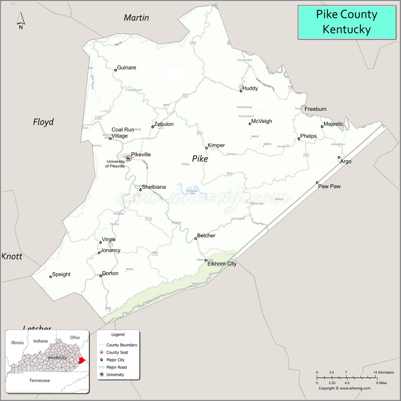
About Pike County Map, Kentucky: The map showing the county boundary, county seat, major cities, highways, water bodies and neighbouring counties.
More Kentucky Maps & Info
Map of Pike County, Kentucky
Pike County is a county located in the U.S. state of Kentucky. It's county seat is Pikeville. As per 2020 census, the population of Pike County is 57391 people and population density is square miles. According to the United States Census Bureau, the county has a total area of 788 sq mi (2,041 km2). Pike County was established on 1821.
Pike County Facts
| Continent | North America |
| Country | United States |
| State | Kentucky |
| County Seat | Pikeville |
| Largest City/Town | Pikeville |
| Established | 1821 |
| Total Area | 789 sq mi (2,044 sq km) |
| Land Area | 787 sq mi (2,039 sq km) |
| Water Area | 1.8 sq mi (5 sq km) |
| Population | 58,669 (Census 2020) |
| Population Density | 75 people per sq mi |
| Time Zone | Eastern Time Zone (ET) |
| Major Highways | U.S. Route 23, U.S. Route 119, Kentucky Route 80, Hal Rogers Parkway nearby area |
| Major Rivers | Levisa Fork River, Tug Fork River |
| Neighboring Counties | Martin County, Floyd County, Knott County, Letcher County, Buchanan County (VA), Mingo County (WV) |
| Famous For | Appalachian coal mining heritage, Pikeville Cut-Through Project, Hatfield-McCoy history, and mountain landscapes |
| Top Attractions | Pikeville Cut-Through, Breaks Interstate Park nearby area, Hatfield-McCoy Historic Sites, University of Pikeville, Jenny Wiley State Resort Park nearby area |
| Official Website | Official Website |
About Pike County, Kentucky
Pike County is located in far eastern Kentucky within the Appalachian Mountains along the borders of Virginia and West Virginia and was established in 1821. The county seat and largest city is Pikeville. Pike County is known for its coal mining heritage, rugged mountain scenery, Hatfield-McCoy feud history, outdoor recreation, and the massive Pikeville Cut-Through engineering project that reshaped the downtown landscape. ([en.wikipedia.org](https://en.wikipedia.org/wiki/Pike_County%2C_Kentucky?utm_source=chatgpt.com))
Cities and Communities in Pike County, Kentucky
| City/Town | Population | Latitude & Longitude |
|---|---|---|
| Pikeville (county seat) | 7,000+ | 37.4793°N, 82.5188°W |
| Coal Run Village | 1,300+ | 37.5057°N, 82.5468°W |
| Elkhorn City | 900+ | 37.3037°N, 82.3507°W |
| South Williamson | 600+ | 37.6732°N, 82.2774°W |
| Virgie | Mountain Community | 37.3331°N, 82.5648°W |
| Belfry | Historic Community | 37.6298°N, 82.2687°W |
| Kimper | Rural Community | 37.5135°N, 82.2928°W |
| Phelps | Coalfield Area | 37.5110°N, 82.1512°W |
Best Golf Courses in Pike County, Kentucky
| Golf Course | Location | Latitude & Longitude |
|---|---|---|
| Pikeville Country Club | Pikeville | 37.4548°N, 82.5097°W |
| StoneCrest Golf Course | Nearby Prestonsburg | 37.6941°N, 82.7712°W |
| Sleepy Hollow Golf Course | Nearby Cumberland | 36.9781°N, 82.9884°W |
| Sag Hollow Golf Club | Nearby Paintsville | 37.7862°N, 82.7875°W |
What are Major Roads and Highways in Pike County
Major highways connect Pike County with Appalachian Kentucky, Virginia, West Virginia, and regional coalfield communities.
- U.S. Route 23 - major north-south corridor through Pikeville and eastern Kentucky
- U.S. Route 119 - important Appalachian highway connecting Kentucky and West Virginia
- Kentucky Route 80 - regional east-west route through mountain communities
- Hal Rogers Parkway nearby area - transportation corridor linking eastern Kentucky regions
Neighboring Counties of Pike County
- Martin County (north)
- Floyd County (northwest)
- Knott County (west)
- Letcher County (southwest)
- Buchanan County, Virginia (southeast)
- Mingo County, West Virginia (east)
What are Top Attractions in Pike County, Kentucky
The county offers Appalachian heritage sites, mountain recreation, historic landmarks, and scenic outdoor destinations.
| Main Sight Name | City | Famous For |
|---|---|---|
| Pikeville Cut-Through | Pikeville | Massive engineering project through the mountains |
| Breaks Interstate Park Nearby Area | Regional Area | Mountain overlooks, hiking, and canyon scenery |
| Hatfield-McCoy Historic Sites | Countywide | Famous Appalachian feud history |
| University of Pikeville | Pikeville | Higher education campus and Appalachian culture |
| Jenny Wiley State Resort Park Nearby Area | Regional Area | Boating, hiking, and outdoor recreation |
| Historic Downtown Pikeville | Pikeville | Local shops, restaurants, and cultural attractions |
| Levisa Fork River Recreation | Countywide | Fishing and riverside scenery |
| Appalachian Mountain Drives | Countywide | Mountain overlooks and scenic photography |
| Coal Mining Heritage Areas | Countywide | Regional mining history and Appalachian traditions |
| Community Festivals and Events | Pikeville Area | Mountain music, arts, and local celebrations |
Distance from Pike County to Nearby Cities
The following distances are measured by road (driving).
- Pikeville to Prestonsburg, Kentucky - 29 mi (47 km)
- Pikeville to Huntington, West Virginia - 97 mi (156 km)
- Pikeville to Charleston, West Virginia - 139 mi (224 km)
- Pikeville to Lexington, Kentucky - 140 mi (225 km)
- Pikeville to Knoxville, Tennessee - 172 mi (277 km)
- Pikeville to Louisville, Kentucky - 223 mi (359 km)
- Pikeville to Cincinnati, Ohio - 232 mi (373 km)
- Pikeville to Nashville, Tennessee - 284 mi (457 km)
- Pikeville to Columbus, Ohio - 292 mi (470 km)
- Pikeville to Atlanta, Georgia - 316 mi (509 km)
- Pikeville to Indianapolis, Indiana - 334 mi (537 km)
- Pikeville to Charlotte, North Carolina - 259 mi (417 km)
References
- Pike County Official Website
- Pike County, Kentucky - Wikipedia
- U.S. Census Bureau QuickFacts
- Breaks Interstate Park
- Kentucky Tourism
- Adair County Map
- Allen County Map
- Anderson County Map
- Ballard County Map
- Barren County Map
- Bath County Map
- Bell County Map
- Boone County Map
- Bourbon County Map
- Boyd County Map
- Boyle County Map
- Bracken County Map
- Breathitt County Map
- Breckinridge County Map
- Bullitt County Map
- Butler County Map
- Caldwell County Map
- Calloway County Map
- Campbell County Map
- Carlisle County Map
- Carroll County Map
- Carter County Map
- Casey County Map
- Christian County Map
- Clark County Map
- Clay County Map
- Clinton County Map
- Crittenden County Map
- Cumberland County Map
- Daviess County Map
- Edmonson County Map
- Elliott County Map
- Estill County Map
- Fayette County Map
- Fleming County Map
- Floyd County Map
- Franklin County Map
- Fulton County Map
- Gallatin County Map
- Garrard County Map
- Grant County Map
- Graves County Map
- Grayson County Map
- Green County Map
- Greenup County Map
- Hancock County Map
- Hardin County Map
- Harlan County Map
- Harrison County Map
- Hart County Map
- Henderson County Map
- Henry County Map
- Hickman County Map
- Hopkins County Map
- Jackson County Map
- Jefferson County Map
- Jessamine County Map
- Johnson County Map
- Kenton County Map
- Knott County Map
- Knox County Map
- LaRue County Map
- Laurel County Map
- Lawrence County Map
- Lee County Map
- Leslie County Map
- Letcher County Map
- Lewis County Map
- Lincoln County Map
- Livingston County Map
- Logan County Map
- Lyon County Map
- McCracken County Map
- McCreary County Map
- McLean County Map
- Madison County Map
- Magoffin County Map
- Marion County Map
- Marshall County Map
- Martin County Map
- Mason County Map
- Meade County Map
- Menifee County Map
- Mercer County Map
- Metcalfe County Map
- Monroe County Map
- Montgomery County Map
- Morgan County Map
- Muhlenberg County Map
- Nelson County Map
- Nicholas County Map
- Ohio County Map
- Oldham County Map
- Owen County Map
- Owsley County Map
- Pendleton County Map
- Perry County Map
- Pike County Map
- Powell County Map
- Pulaski County Map
- Robertson County Map
- Rockcastle County Map
- Rowan County Map
- Russell County Map
- Scott County Map
- Shelby County Map
- Simpson County Map
- Spencer County Map
- Taylor County Map
- Todd County Map
- Trigg County Map
- Trimble County Map
- Union County Map
- Warren County Map
- Washington County Map
- Wayne County Map
- Webster County Map
- Whitley County Map
- Wolfe County Map
- Woodford County Map
- Alabama Counties
- Alaska boroughs
- Arizona Counties
- Arkansas Counties
- California County Map
- Colorado Counties
- Connecticut Counties
- Delaware Counties
- Florida County Map
- Georgia County Map
- Hawaii Counties
- Idaho Counties
- Illinois Counties
- Indiana Counties
- Iowa Counties
- Kansas Counties
- Kentucky Counties
- Louisiana Counties
- Maine Counties
- Maryland Counties
- Massachusetts Counties
- Michigan County Map
- Minnesota Counties
- Mississippi Counties
- Missouri Counties
- Montana Counties
- Nebraska Counties
- Nevada Counties
- New York Counties
- New Hampshire Counties
- New Jersey Counties
- New Mexico Counties
- North Carolina Counties
- North Dakota Counties
- Ohio County Map
- Oklahoma Counties
- Oregon Counties
- Pennsylvania Counties
- Rhode Island Counties
- South Carolina Counties
- South Dakota Counties
- Map of Tennessee
- Texas County Map
- Utah Counties
- Vermont Counties
- Virginia Counties
- Washington Counties
- West Virginia Counties
- Wisconsin Counties
- Wyoming Counties