Map of Henderson County - Henderson County is a county located in the U.S. state of Kentucky. Henderson County Map showing cities, highways, important places and water bodies. Get Where is Henderson County located in the map, major cities in Henderson county, population, areas, and places of interest.
Map of Henderson County, Kentucky
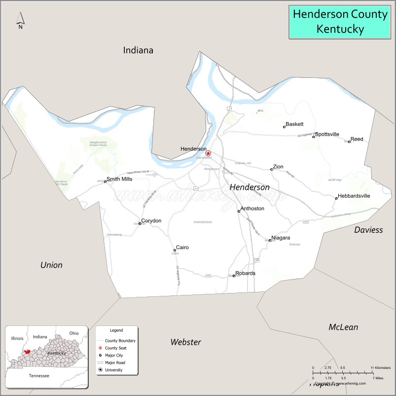
About Henderson County Map, Kentucky: The map showing the county boundary, county seat, major cities, highways, water bodies and neighbouring counties.
More Kentucky Maps & Info
Map of Henderson County, Kentucky
Henderson County is a county located in the U.S. state of Kentucky. It's county seat is Henderson. As per 2020 census, the population of Henderson County is 44329 people and population density is square miles. According to the United States Census Bureau, the county has a total area of 440 sq mi (1,140 km2). Henderson County was established on 1798.
Henderson County Facts
| Continent | North America |
| Country | United States |
| State | Kentucky |
| County Seat | Henderson |
| Largest City/Town | Henderson |
| Established | 1798 |
| Total Area | 466 sq mi (1,207 sq km) |
| Land Area | 437 sq mi (1,132 sq km) |
| Water Area | 29 sq mi (75 sq km) |
| Population | 44,793 (Census 2020) |
| Population Density | 102 people per sq mi |
| Time Zone | Central Time Zone (CT) |
| Major Highways | Interstate 69, U.S. Route 41, U.S. Route 60, Kentucky Route 351 |
| Major Rivers | Ohio River, Green River |
| Neighboring Counties | Union County, Webster County, Daviess County, Posey County (IN), Vanderburgh County (IN) |
| Famous For | Ohio River commerce, bluegrass music heritage, John James Audubon history, and riverfront recreation |
| Top Attractions | John James Audubon State Park, Henderson Riverfront, Audubon Museum, Ellis Park Racing & Gaming nearby area, Atkinson Park |
| Official Website | Official Website |
About Henderson County, Kentucky
Henderson County is located in northwestern Kentucky along the Ohio River and was established in 1798. The county seat and largest city is Henderson. Henderson County is known for its riverfront heritage, music traditions, wildlife areas, historic downtown district, and connection to naturalist John James Audubon. ([en.wikipedia.org](https://en.wikipedia.org/wiki/Henderson_County%2C_Kentucky?utm_source=chatgpt.com))
Cities and Communities in Henderson County, Kentucky
| City/Town | Population | Latitude & Longitude |
|---|---|---|
| Henderson (county seat) | 28,000+ | 37.8362°N, 87.5900°W |
| Corydon | 700+ | 37.7381°N, 87.7039°W |
| Robards | 500+ | 37.6795°N, 87.5483°W |
| Anthoston | Unincorporated | 37.7514°N, 87.4894°W |
| Zion | Rural Community | 37.8605°N, 87.6550°W |
| Spottsville | Historic Community | 37.8629°N, 87.4188°W |
| Niagara | Unincorporated | 37.7997°N, 87.6407°W |
| Geneva | Historic River Community | 37.9234°N, 87.7420°W |
Best Golf Courses in Henderson County, Kentucky
| Golf Course | Location | Latitude & Longitude |
|---|---|---|
| Henderson Country Club | Henderson | 37.8238°N, 87.5755°W |
| Bent Creek Golf Course | Henderson Area | 37.7898°N, 87.5484°W |
| Cambridge Golf Course | Nearby Evansville, Indiana | 37.9660°N, 87.4806°W |
| Quail Crossing Golf Club | Nearby Boonville, Indiana | 38.0455°N, 87.2448°W |
What are Major Roads and Highways in Henderson County
Major highways connect Henderson County with Evansville, Owensboro, and regional Ohio River communities.
- Interstate 69 - major interstate corridor linking western Kentucky and Indiana
- U.S. Route 41 - important north-south route crossing the Ohio River into Indiana
- U.S. Route 60 - east-west highway connecting Henderson with surrounding Kentucky counties
- Kentucky Route 351 - regional roadway serving local communities and industrial areas
Neighboring Counties of Henderson County
- Union County (west)
- Webster County (south)
- Daviess County (east)
- Posey County, Indiana (northwest across the Ohio River)
- Vanderburgh County, Indiana (north across the Ohio River)
What are Top Attractions in Henderson County, Kentucky
The county offers riverfront attractions, museums, parks, horse racing entertainment, and outdoor recreation areas.
| Main Sight Name | City | Famous For |
|---|---|---|
| John James Audubon State Park | Henderson | Nature trails, museum exhibits, and wildlife scenery |
| Henderson Riverfront | Henderson | Ohio River views and community festivals |
| Audubon Museum | Henderson | Art and natural history collections |
| Ellis Park Racing & Gaming Nearby Area | Henderson Area | Horse racing and entertainment venue |
| Atkinson Park | Henderson | Sports facilities and outdoor recreation |
| Historic Downtown Henderson | Henderson | Restaurants, boutiques, and riverfront culture |
| Ohio River Scenic Areas | Countywide | Photography and riverside landscapes |
| John James Audubon Theater | Henderson | Live performances and arts events |
| Green River Recreation Areas | Countywide | Fishing, boating, and wildlife viewing |
| Bluegrass Music Heritage Sites | Countywide | Regional music history and local festivals |
Distance from Henderson County to Nearby Cities
The following distances are measured by road (driving).
- Henderson to Evansville, Indiana - 11 mi (18 km)
- Henderson to Owensboro, Kentucky - 32 mi (51 km)
- Henderson to Bowling Green, Kentucky - 102 mi (164 km)
- Henderson to Louisville, Kentucky - 128 mi (206 km)
- Henderson to Nashville, Tennessee - 154 mi (248 km)
- Henderson to Paducah, Kentucky - 111 mi (179 km)
- Henderson to Indianapolis, Indiana - 170 mi (274 km)
- Henderson to St. Louis, Missouri - 174 mi (280 km)
- Henderson to Lexington, Kentucky - 199 mi (320 km)
- Henderson to Memphis, Tennessee - 233 mi (375 km)
- Henderson to Cincinnati, Ohio - 236 mi (380 km)
- Henderson to Chicago, Illinois - 308 mi (496 km)
References
- Henderson County Official Website
- Henderson County, Kentucky - Wikipedia
- U.S. Census Bureau QuickFacts
- John James Audubon State Park
- Henderson Tourism Commission
- Adair County Map
- Allen County Map
- Anderson County Map
- Ballard County Map
- Barren County Map
- Bath County Map
- Bell County Map
- Boone County Map
- Bourbon County Map
- Boyd County Map
- Boyle County Map
- Bracken County Map
- Breathitt County Map
- Breckinridge County Map
- Bullitt County Map
- Butler County Map
- Caldwell County Map
- Calloway County Map
- Campbell County Map
- Carlisle County Map
- Carroll County Map
- Carter County Map
- Casey County Map
- Christian County Map
- Clark County Map
- Clay County Map
- Clinton County Map
- Crittenden County Map
- Cumberland County Map
- Daviess County Map
- Edmonson County Map
- Elliott County Map
- Estill County Map
- Fayette County Map
- Fleming County Map
- Floyd County Map
- Franklin County Map
- Fulton County Map
- Gallatin County Map
- Garrard County Map
- Grant County Map
- Graves County Map
- Grayson County Map
- Green County Map
- Greenup County Map
- Hancock County Map
- Hardin County Map
- Harlan County Map
- Harrison County Map
- Hart County Map
- Henderson County Map
- Henry County Map
- Hickman County Map
- Hopkins County Map
- Jackson County Map
- Jefferson County Map
- Jessamine County Map
- Johnson County Map
- Kenton County Map
- Knott County Map
- Knox County Map
- LaRue County Map
- Laurel County Map
- Lawrence County Map
- Lee County Map
- Leslie County Map
- Letcher County Map
- Lewis County Map
- Lincoln County Map
- Livingston County Map
- Logan County Map
- Lyon County Map
- McCracken County Map
- McCreary County Map
- McLean County Map
- Madison County Map
- Magoffin County Map
- Marion County Map
- Marshall County Map
- Martin County Map
- Mason County Map
- Meade County Map
- Menifee County Map
- Mercer County Map
- Metcalfe County Map
- Monroe County Map
- Montgomery County Map
- Morgan County Map
- Muhlenberg County Map
- Nelson County Map
- Nicholas County Map
- Ohio County Map
- Oldham County Map
- Owen County Map
- Owsley County Map
- Pendleton County Map
- Perry County Map
- Pike County Map
- Powell County Map
- Pulaski County Map
- Robertson County Map
- Rockcastle County Map
- Rowan County Map
- Russell County Map
- Scott County Map
- Shelby County Map
- Simpson County Map
- Spencer County Map
- Taylor County Map
- Todd County Map
- Trigg County Map
- Trimble County Map
- Union County Map
- Warren County Map
- Washington County Map
- Wayne County Map
- Webster County Map
- Whitley County Map
- Wolfe County Map
- Woodford County Map
- Alabama Counties
- Alaska boroughs
- Arizona Counties
- Arkansas Counties
- California County Map
- Colorado Counties
- Connecticut Counties
- Delaware Counties
- Florida County Map
- Georgia County Map
- Hawaii Counties
- Idaho Counties
- Illinois Counties
- Indiana Counties
- Iowa Counties
- Kansas Counties
- Kentucky Counties
- Louisiana Counties
- Maine Counties
- Maryland Counties
- Massachusetts Counties
- Michigan County Map
- Minnesota Counties
- Mississippi Counties
- Missouri Counties
- Montana Counties
- Nebraska Counties
- Nevada Counties
- New York Counties
- New Hampshire Counties
- New Jersey Counties
- New Mexico Counties
- North Carolina Counties
- North Dakota Counties
- Ohio County Map
- Oklahoma Counties
- Oregon Counties
- Pennsylvania Counties
- Rhode Island Counties
- South Carolina Counties
- South Dakota Counties
- Map of Tennessee
- Texas County Map
- Utah Counties
- Vermont Counties
- Virginia Counties
- Washington Counties
- West Virginia Counties
- Wisconsin Counties
- Wyoming Counties