Map of Calloway County - Calloway County is a county located in the U.S. state of Kentucky. Calloway County Map showing cities, highways, important places and water bodies. Get Where is Calloway County located in the map, major cities in Calloway county, population, areas, and places of interest.
Map of Calloway County, Kentucky
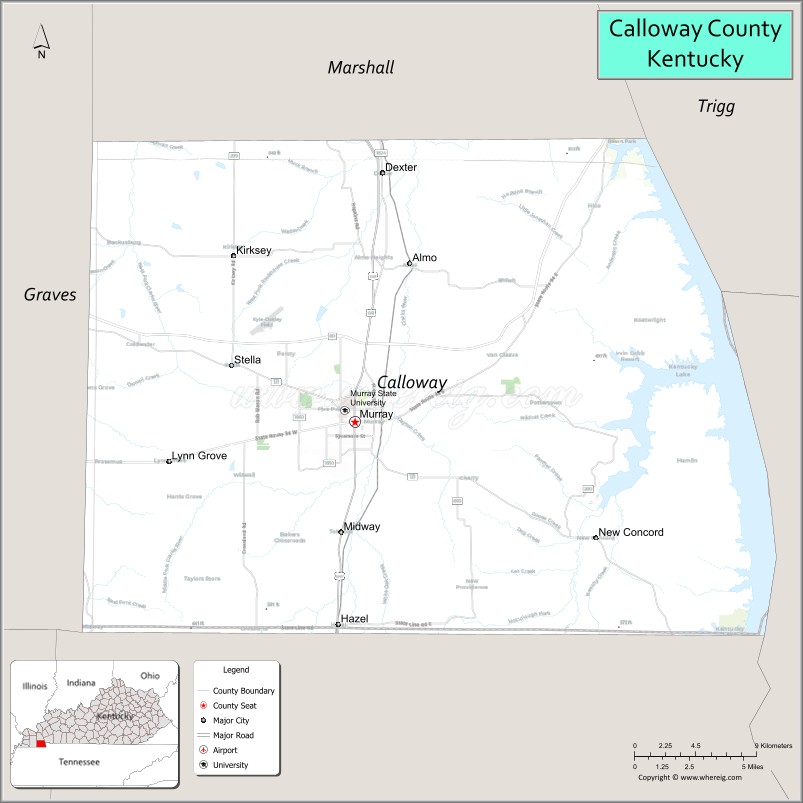
About Calloway County Map, Kentucky: The map showing the county boundary, county seat, major cities, highways, water bodies and neighbouring counties.
More Kentucky Maps & Info
Map of Calloway County, Kentucky
Calloway County is a county located in the U.S. state of Kentucky. It's county seat is Murray. As per 2020 census, the population of Calloway County is 37560 people and population density is square miles. According to the United States Census Bureau, the county has a total area of 386 sq mi (1,000 km2). Calloway County was established on 1822.
Calloway County Facts
| Continent | North America |
| Country | United States |
| State | Kentucky |
| County Seat | Murray |
| Largest City/Town | Murray |
| Established | 1822 |
| Total Area | 411 sq mi (1,064 sq km) |
| Land Area | 385 sq mi (997 sq km) |
| Water Area | 26 sq mi (67 sq km) |
| Population | 37,103 (Census 2020) |
| Population Density | 96 people per sq mi |
| Time Zone | Central Time Zone (CT) |
| Major Highways | U.S. Route 641, Kentucky Route 80, Kentucky Route 94, Purchase Parkway nearby area |
| Major Rivers | Tennessee River, Clarks River |
| Neighboring Counties | Marshall County, Trigg County, Graves County, Henry County (TN), Stewart County (TN) |
| Famous For | Murray State University, Kentucky Lake, outdoor recreation, and western Kentucky culture |
| Top Attractions | Kentucky Lake, Murray State University, Land Between the Lakes nearby area, Wrather West Kentucky Museum, Central Park Murray |
| Official Website | Official Website |
About Calloway County, Kentucky
Calloway County is located in southwestern Kentucky near the Tennessee border and was established in 1822. The county seat and largest city is Murray. Calloway County is known for Murray State University, access to Kentucky Lake, outdoor recreation, and its strong educational and cultural traditions in western Kentucky. ([en.wikipedia.org](https://en.wikipedia.org/wiki/Calloway_County%2C_Kentucky?utm_source=chatgpt.com))
Cities and Communities in Calloway County, Kentucky
| City/Town | Population | Latitude & Longitude |
|---|---|---|
| Murray (county seat) | 17,700+ | 36.6103°N, 88.3148°W |
| Dexter | Unincorporated | 36.6998°N, 88.2902°W |
| Kirksey | Unincorporated | 36.7072°N, 88.4319°W |
| Almo | Unincorporated | 36.7004°N, 88.2698°W |
| New Concord | Unincorporated | 36.5486°N, 88.1381°W |
| Coldwater | Historic Community | 36.6607°N, 88.2194°W |
| Lynn Grove | Unincorporated | 36.5661°N, 88.2988°W |
| Faxon | Unincorporated | 36.5795°N, 88.3920°W |
Best Golf Courses in Calloway County, Kentucky
| Golf Course | Location | Latitude & Longitude |
|---|---|---|
| Miller Memorial Golf Course | Murray | 36.6171°N, 88.3225°W |
| Cherry Corner Golf Course | Murray Area | 36.6233°N, 88.2481°W |
| Kentucky Dam Village Golf Course | Nearby Gilbertsville | 37.0051°N, 88.2709°W |
| Calvert City Golf & Country Club | Nearby Calvert City | 37.0437°N, 88.3465°W |
What are Major Roads and Highways in Calloway County
Major highways connect Calloway County with western Kentucky cities and recreational destinations.
- U.S. Route 641 - major north-south highway connecting Murray with Paducah and Tennessee
- Kentucky Route 80 - important east-west route across western Kentucky
- Kentucky Route 94 - regional route serving Murray and nearby communities
- Purchase Parkway nearby area - major transportation corridor connecting western Kentucky regions
Neighboring Counties of Calloway County
- Marshall County (north)
- Trigg County (east)
- Graves County (west)
- Henry County, Tennessee (southwest)
- Stewart County, Tennessee (southeast)
What are Top Attractions in Calloway County, Kentucky
The county offers educational attractions, lake recreation, and outdoor activities.
| Main Sight Name | City | Famous For |
|---|---|---|
| Kentucky Lake | Western County Area | Boating, fishing, and water recreation |
| Murray State University | Murray | Higher education and cultural events |
| Land Between the Lakes Nearby Area | Regional Area | Outdoor recreation, wildlife, and camping |
| Wrather West Kentucky Museum | Murray | Regional history and cultural exhibits |
| Central Park | Murray | Community events and outdoor recreation |
| Arboretum at Murray State | Murray | Nature trails and botanical collections |
| Historic Downtown Murray | Murray | Local shops, restaurants, and entertainment |
| Clarks River National Wildlife Refuge Nearby Area | Regional Area | Birdwatching and wildlife habitat |
| Playhouse in the Park | Murray | Community theater and performing arts |
| Kentucky Lake Scenic Drives | Countywide | Lake views and countryside landscapes |
Distance from Calloway County to Nearby Cities
The following distances are measured by road (driving).
- Murray to Paducah, Kentucky - 48 mi (77 km)
- Murray to Hopkinsville, Kentucky - 69 mi (111 km)
- Murray to Nashville, Tennessee - 118 mi (190 km)
- Murray to Clarksville, Tennessee - 91 mi (146 km)
- Murray to Bowling Green, Kentucky - 124 mi (200 km)
- Murray to Evansville, Indiana - 121 mi (195 km)
- Murray to Memphis, Tennessee - 160 mi (257 km)
- Murray to Louisville, Kentucky - 230 mi (370 km)
- Murray to St. Louis, Missouri - 213 mi (343 km)
- Murray to Lexington, Kentucky - 261 mi (420 km)
- Murray to Jackson, Tennessee - 95 mi (153 km)
- Murray to Indianapolis, Indiana - 255 mi (410 km)
References
- Calloway County Official Website
- Calloway County, Kentucky - Wikipedia
- U.S. Census Bureau QuickFacts
- Murray State University
- Kentucky Tourism
- Adair County Map
- Allen County Map
- Anderson County Map
- Ballard County Map
- Barren County Map
- Bath County Map
- Bell County Map
- Boone County Map
- Bourbon County Map
- Boyd County Map
- Boyle County Map
- Bracken County Map
- Breathitt County Map
- Breckinridge County Map
- Bullitt County Map
- Butler County Map
- Caldwell County Map
- Calloway County Map
- Campbell County Map
- Carlisle County Map
- Carroll County Map
- Carter County Map
- Casey County Map
- Christian County Map
- Clark County Map
- Clay County Map
- Clinton County Map
- Crittenden County Map
- Cumberland County Map
- Daviess County Map
- Edmonson County Map
- Elliott County Map
- Estill County Map
- Fayette County Map
- Fleming County Map
- Floyd County Map
- Franklin County Map
- Fulton County Map
- Gallatin County Map
- Garrard County Map
- Grant County Map
- Graves County Map
- Grayson County Map
- Green County Map
- Greenup County Map
- Hancock County Map
- Hardin County Map
- Harlan County Map
- Harrison County Map
- Hart County Map
- Henderson County Map
- Henry County Map
- Hickman County Map
- Hopkins County Map
- Jackson County Map
- Jefferson County Map
- Jessamine County Map
- Johnson County Map
- Kenton County Map
- Knott County Map
- Knox County Map
- LaRue County Map
- Laurel County Map
- Lawrence County Map
- Lee County Map
- Leslie County Map
- Letcher County Map
- Lewis County Map
- Lincoln County Map
- Livingston County Map
- Logan County Map
- Lyon County Map
- McCracken County Map
- McCreary County Map
- McLean County Map
- Madison County Map
- Magoffin County Map
- Marion County Map
- Marshall County Map
- Martin County Map
- Mason County Map
- Meade County Map
- Menifee County Map
- Mercer County Map
- Metcalfe County Map
- Monroe County Map
- Montgomery County Map
- Morgan County Map
- Muhlenberg County Map
- Nelson County Map
- Nicholas County Map
- Ohio County Map
- Oldham County Map
- Owen County Map
- Owsley County Map
- Pendleton County Map
- Perry County Map
- Pike County Map
- Powell County Map
- Pulaski County Map
- Robertson County Map
- Rockcastle County Map
- Rowan County Map
- Russell County Map
- Scott County Map
- Shelby County Map
- Simpson County Map
- Spencer County Map
- Taylor County Map
- Todd County Map
- Trigg County Map
- Trimble County Map
- Union County Map
- Warren County Map
- Washington County Map
- Wayne County Map
- Webster County Map
- Whitley County Map
- Wolfe County Map
- Woodford County Map
- Alabama Counties
- Alaska boroughs
- Arizona Counties
- Arkansas Counties
- California County Map
- Colorado Counties
- Connecticut Counties
- Delaware Counties
- Florida County Map
- Georgia County Map
- Hawaii Counties
- Idaho Counties
- Illinois Counties
- Indiana Counties
- Iowa Counties
- Kansas Counties
- Kentucky Counties
- Louisiana Counties
- Maine Counties
- Maryland Counties
- Massachusetts Counties
- Michigan County Map
- Minnesota Counties
- Mississippi Counties
- Missouri Counties
- Montana Counties
- Nebraska Counties
- Nevada Counties
- New York Counties
- New Hampshire Counties
- New Jersey Counties
- New Mexico Counties
- North Carolina Counties
- North Dakota Counties
- Ohio County Map
- Oklahoma Counties
- Oregon Counties
- Pennsylvania Counties
- Rhode Island Counties
- South Carolina Counties
- South Dakota Counties
- Map of Tennessee
- Texas County Map
- Utah Counties
- Vermont Counties
- Virginia Counties
- Washington Counties
- West Virginia Counties
- Wisconsin Counties
- Wyoming Counties