Map of Christian County - Christian County is a county located in the U.S. state of Kentucky. Christian County Map showing cities, highways, important places and water bodies. Get Where is Christian County located in the map, major cities in Christian county, population, areas, and places of interest.
Map of Christian County, Kentucky
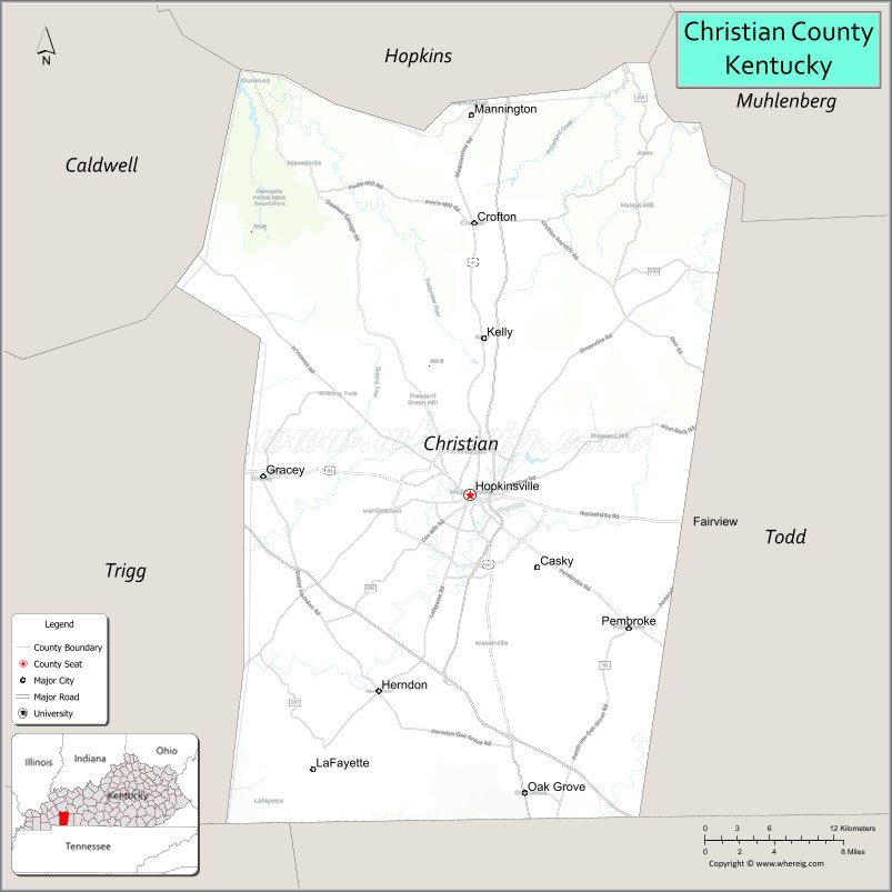
About Christian County Map, Kentucky: The map showing the county boundary, county seat, major cities, highways, water bodies and neighbouring counties.
More Kentucky Maps & Info
Map of Christian County, Kentucky
Christian County is a county located in the U.S. state of Kentucky. It's county seat is Hopkinsville. As per 2020 census, the population of Christian County is 72357 people and population density is square miles. According to the United States Census Bureau, the county has a total area of 721 sq mi (1,867 km2). Christian County was established on 1796.
Christian County Facts
| Continent | North America |
| Country | United States |
| State | Kentucky |
| County Seat | Hopkinsville |
| Largest City/Town | Hopkinsville |
| Established | 1797 |
| Total Area | 724 sq mi (1,875 sq km) |
| Land Area | 718 sq mi (1,860 sq km) |
| Water Area | 6 sq mi (16 sq km) |
| Population | 72,748 (Census 2020) |
| Population Density | 101 people per sq mi |
| Time Zone | Central Time Zone (CT) |
| Major Highways | Interstate 24 nearby area, Pennyrile Parkway, U.S. Route 41, U.S. Route 68, Kentucky Route 80 |
| Major Rivers | Little River, Tradewater River nearby area |
| Neighboring Counties | Todd County, Trigg County, Caldwell County, Hopkins County, Muhlenberg County, Montgomery County (TN) |
| Famous For | Fort Campbell, Hopkinsville, solar eclipse tourism, agriculture, and military heritage |
| Top Attractions | Fort Campbell nearby area, Trail of Tears Commemorative Park, Jeffers Bend Environmental Center, Pennyroyal Area Museum, Tie Breaker Family Aquatic Center |
| Official Website | Official Website |
About Christian County, Kentucky
Christian County is located in southwestern Kentucky along the Tennessee border and was established in 1797. The county seat and largest city is Hopkinsville. Christian County is known for Fort Campbell military influence, strong agricultural traditions, historical landmarks, and its role as a regional center in western Kentucky. ([en.wikipedia.org](https://en.wikipedia.org/wiki/Christian_County%2C_Kentucky?utm_source=chatgpt.com))
Cities and Communities in Christian County, Kentucky
| City/Town | Population | Latitude & Longitude |
|---|---|---|
| Hopkinsville (county seat) | 31,000+ | 36.8656°N, 87.4886°W |
| Oak Grove | 8,000+ | 36.6578°N, 87.4425°W |
| Pembroke | 850+ | 36.7745°N, 87.3550°W |
| Crofton | 750+ | 37.0470°N, 87.4850°W |
| Lafayette | 200+ | 36.6673°N, 87.4894°W |
| Herndon | 500+ | 36.7234°N, 87.5970°W |
| Kelly | Historic Community | 36.8503°N, 87.4599°W |
| Fearsville | Unincorporated | 36.9522°N, 87.6351°W |
Best Golf Courses in Christian County, Kentucky
| Golf Course | Location | Latitude & Longitude |
|---|---|---|
| The Links at Novadell | Hopkinsville | 36.8401°N, 87.4687°W |
| Western Hills Golf Course | Hopkinsville | 36.8588°N, 87.5284°W |
| Cole Park Golf Course | Fort Campbell Nearby Area | 36.6639°N, 87.4774°W |
| Pennyrile Forest State Resort Park Golf Course | Nearby Dawson Springs | 37.0782°N, 87.7428°W |
What are Major Roads and Highways in Christian County
Major highways connect Christian County with western Kentucky, Tennessee, and regional military facilities.
- Pennyrile Parkway - major north-south route connecting Hopkinsville with Interstate 69 and Tennessee
- U.S. Route 41 - important regional highway serving Hopkinsville and surrounding communities
- U.S. Route 68 - east-west highway linking Hopkinsville with Cadiz and Bowling Green
- Kentucky Route 80 - regional connector serving western Kentucky communities
- Interstate 24 nearby area - interstate access connecting western Kentucky and Nashville
Neighboring Counties of Christian County
- Todd County (east)
- Trigg County (west)
- Caldwell County (northwest)
- Hopkins County (north)
- Muhlenberg County (northeast)
- Montgomery County, Tennessee (south)
What are Top Attractions in Christian County, Kentucky
The county features military history, parks, museums, and family recreation attractions.
| Main Sight Name | City | Famous For |
|---|---|---|
| Fort Campbell Nearby Area | Oak Grove Area | Major U.S. Army installation and military heritage |
| Trail of Tears Commemorative Park | Hopkinsville | Cherokee history and memorial sites |
| Jeffers Bend Environmental Center | Hopkinsville | Nature trails and educational exhibits |
| Pennyroyal Area Museum | Hopkinsville | Regional history and cultural displays |
| Tie Breaker Family Aquatic Center | Hopkinsville | Water recreation and family entertainment |
| Historic Downtown Hopkinsville | Hopkinsville | Restaurants, murals, and local shops |
| Casey Jones Distillery | Hopkinsville Area | Craft spirits and Kentucky distilling heritage |
| Western Kentucky State Fairgrounds | Hopkinsville | Events, fairs, and agricultural exhibitions |
| Little River Scenic Areas | Countywide | Fishing and countryside recreation |
| Solar Eclipse Viewing Heritage Sites | Hopkinsville Area | Historic 2017 eclipse tourism destination |
Distance from Christian County to Nearby Cities
The following distances are measured by road (driving).
- Hopkinsville to Clarksville, Tennessee - 26 mi (42 km)
- Hopkinsville to Nashville, Tennessee - 72 mi (116 km)
- Hopkinsville to Paducah, Kentucky - 83 mi (134 km)
- Hopkinsville to Bowling Green, Kentucky - 70 mi (113 km)
- Hopkinsville to Owensboro, Kentucky - 86 mi (138 km)
- Hopkinsville to Evansville, Indiana - 108 mi (174 km)
- Hopkinsville to Louisville, Kentucky - 170 mi (274 km)
- Hopkinsville to Lexington, Kentucky - 198 mi (319 km)
- Hopkinsville to Memphis, Tennessee - 213 mi (343 km)
- Hopkinsville to St. Louis, Missouri - 259 mi (417 km)
- Hopkinsville to Chattanooga, Tennessee - 218 mi (351 km)
- Hopkinsville to Indianapolis, Indiana - 243 mi (391 km)
References
- Christian County Official Website
- Christian County, Kentucky - Wikipedia
- U.S. Census Bureau QuickFacts
- Visit Hopkinsville Tourism
- Kentucky Atlas and Gazetteer
- Adair County Map
- Allen County Map
- Anderson County Map
- Ballard County Map
- Barren County Map
- Bath County Map
- Bell County Map
- Boone County Map
- Bourbon County Map
- Boyd County Map
- Boyle County Map
- Bracken County Map
- Breathitt County Map
- Breckinridge County Map
- Bullitt County Map
- Butler County Map
- Caldwell County Map
- Calloway County Map
- Campbell County Map
- Carlisle County Map
- Carroll County Map
- Carter County Map
- Casey County Map
- Christian County Map
- Clark County Map
- Clay County Map
- Clinton County Map
- Crittenden County Map
- Cumberland County Map
- Daviess County Map
- Edmonson County Map
- Elliott County Map
- Estill County Map
- Fayette County Map
- Fleming County Map
- Floyd County Map
- Franklin County Map
- Fulton County Map
- Gallatin County Map
- Garrard County Map
- Grant County Map
- Graves County Map
- Grayson County Map
- Green County Map
- Greenup County Map
- Hancock County Map
- Hardin County Map
- Harlan County Map
- Harrison County Map
- Hart County Map
- Henderson County Map
- Henry County Map
- Hickman County Map
- Hopkins County Map
- Jackson County Map
- Jefferson County Map
- Jessamine County Map
- Johnson County Map
- Kenton County Map
- Knott County Map
- Knox County Map
- LaRue County Map
- Laurel County Map
- Lawrence County Map
- Lee County Map
- Leslie County Map
- Letcher County Map
- Lewis County Map
- Lincoln County Map
- Livingston County Map
- Logan County Map
- Lyon County Map
- McCracken County Map
- McCreary County Map
- McLean County Map
- Madison County Map
- Magoffin County Map
- Marion County Map
- Marshall County Map
- Martin County Map
- Mason County Map
- Meade County Map
- Menifee County Map
- Mercer County Map
- Metcalfe County Map
- Monroe County Map
- Montgomery County Map
- Morgan County Map
- Muhlenberg County Map
- Nelson County Map
- Nicholas County Map
- Ohio County Map
- Oldham County Map
- Owen County Map
- Owsley County Map
- Pendleton County Map
- Perry County Map
- Pike County Map
- Powell County Map
- Pulaski County Map
- Robertson County Map
- Rockcastle County Map
- Rowan County Map
- Russell County Map
- Scott County Map
- Shelby County Map
- Simpson County Map
- Spencer County Map
- Taylor County Map
- Todd County Map
- Trigg County Map
- Trimble County Map
- Union County Map
- Warren County Map
- Washington County Map
- Wayne County Map
- Webster County Map
- Whitley County Map
- Wolfe County Map
- Woodford County Map
- Alabama Counties
- Alaska boroughs
- Arizona Counties
- Arkansas Counties
- California County Map
- Colorado Counties
- Connecticut Counties
- Delaware Counties
- Florida County Map
- Georgia County Map
- Hawaii Counties
- Idaho Counties
- Illinois Counties
- Indiana Counties
- Iowa Counties
- Kansas Counties
- Kentucky Counties
- Louisiana Counties
- Maine Counties
- Maryland Counties
- Massachusetts Counties
- Michigan County Map
- Minnesota Counties
- Mississippi Counties
- Missouri Counties
- Montana Counties
- Nebraska Counties
- Nevada Counties
- New York Counties
- New Hampshire Counties
- New Jersey Counties
- New Mexico Counties
- North Carolina Counties
- North Dakota Counties
- Ohio County Map
- Oklahoma Counties
- Oregon Counties
- Pennsylvania Counties
- Rhode Island Counties
- South Carolina Counties
- South Dakota Counties
- Map of Tennessee
- Texas County Map
- Utah Counties
- Vermont Counties
- Virginia Counties
- Washington Counties
- West Virginia Counties
- Wisconsin Counties
- Wyoming Counties