Map of Floyd County - Floyd County is a county located in the U.S. state of Kentucky. Floyd County Map showing cities, highways, important places and water bodies. Get Where is Floyd County located in the map, major cities in Floyd county, population, areas, and places of interest.
Map of Floyd County, Kentucky
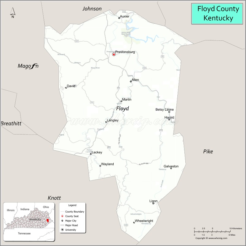
About Floyd County Map, Kentucky: The map showing the county boundary, county seat, major cities, highways, water bodies and neighbouring counties.
More Kentucky Maps & Info
Map of Floyd County, Kentucky
Floyd County is a county located in the U.S. state of Kentucky. It's county seat is Prestonsburg. As per 2020 census, the population of Floyd County is 35274 people and population density is square miles. According to the United States Census Bureau, the county has a total area of 394 sq mi (1,020 km2). Floyd County was established on 1800.
Floyd County Facts
| Continent | North America |
| Country | United States |
| State | Kentucky |
| County Seat | Prestonsburg |
| Largest City/Town | Prestonsburg |
| Established | 1800 |
| Total Area | 396 sq mi (1,026 sq km) |
| Land Area | 393 sq mi (1,018 sq km) |
| Water Area | 3.3 sq mi (9 sq km) |
| Population | 34,423 (Census 2020) |
| Population Density | 88 people per sq mi |
| Time Zone | Eastern Time Zone (ET) |
| Major Highways | U.S. Route 23, Kentucky Route 80, Mountain Parkway nearby area, Kentucky Route 114 |
| Major Rivers | Levisa Fork River, Big Sandy River nearby area |
| Neighboring Counties | Pike County, Johnson County, Magoffin County, Knott County, Martin County |
| Famous For | Appalachian coal mining heritage, country music history, mountain scenery, and Jenny Wiley State Resort Park |
| Top Attractions | Jenny Wiley State Resort Park, Mountain Arts Center, Samuel May House, StoneCrest Golf Course, Dewey Lake |
| Official Website | Official Website |
About Floyd County, Kentucky
Floyd County is located in eastern Kentucky within the Appalachian Mountains and was established in 1800. The county seat and largest city is Prestonsburg. Floyd County is known for its coal mining history, mountain landscapes, Appalachian culture, country music heritage, and outdoor recreation around Dewey Lake and Jenny Wiley State Resort Park. ([en.wikipedia.org](https://en.wikipedia.org/wiki/Floyd_County%2C_Kentucky?utm_source=chatgpt.com))
Cities and Communities in Floyd County, Kentucky
| City/Town | Population | Latitude & Longitude |
|---|---|---|
| Prestonsburg (county seat) | 3,200+ | 37.6659°N, 82.7710°W |
| Wheelwright | 700+ | 37.3356°N, 82.7229°W |
| Allen | 200+ | 37.6062°N, 82.7399°W |
| Martin | 600+ | 37.5723°N, 82.7535°W |
| Wayland | 400+ | 37.4406°N, 82.8060°W |
| Betsy Layne | 500+ | 37.5518°N, 82.6299°W |
| Harold | Unincorporated | 37.5058°N, 82.6418°W |
| McDowell | Historic Community | 37.4451°N, 82.7210°W |
Best Golf Courses in Floyd County, Kentucky
| Golf Course | Location | Latitude & Longitude |
|---|---|---|
| StoneCrest Golf Course | Prestonsburg | 37.6898°N, 82.7817°W |
| Paintsville Country Club | Nearby Paintsville | 37.8299°N, 82.8265°W |
| Pikeville Country Club | Nearby Pikeville | 37.5032°N, 82.5365°W |
| Raven Rock Golf Course | Nearby Jenkins | 37.1807°N, 82.6474°W |
What are Major Roads and Highways in Floyd County
Major highways connect Floyd County with eastern Kentucky communities and the Appalachian region.
- U.S. Route 23 - major north-south highway through eastern Kentucky and Prestonsburg
- Kentucky Route 80 - important east-west corridor connecting Hazard and Pikeville
- Mountain Parkway nearby area - regional transportation route toward central Kentucky
- Kentucky Route 114 - connector route serving Prestonsburg and surrounding communities
Neighboring Counties of Floyd County
- Pike County (east)
- Johnson County (north)
- Magoffin County (west)
- Knott County (southwest)
- Martin County (northeast)
What are Top Attractions in Floyd County, Kentucky
The county features Appalachian culture, mountain recreation, lakes, parks, and music heritage attractions.
| Main Sight Name | City | Famous For |
|---|---|---|
| Jenny Wiley State Resort Park | Prestonsburg Area | Cabins, hiking, boating, and mountain scenery |
| Mountain Arts Center | Prestonsburg | Live music performances and Appalachian arts |
| Samuel May House | Prestonsburg | Historic home and regional heritage |
| StoneCrest Golf Course | Prestonsburg | Mountain golf and scenic views |
| Dewey Lake | Prestonsburg Area | Fishing, boating, and water recreation |
| Middle Creek National Battlefield | Prestonsburg Area | Civil War battlefield and history site |
| Downtown Prestonsburg | Prestonsburg | Local shops, restaurants, and Appalachian culture |
| Levisa Fork River Scenic Area | Countywide | Fishing and mountain river scenery |
| Coal Mining Heritage Sites | Countywide | Historic mining communities and regional history |
| Mountain Scenic Drives | Countywide | Appalachian overlooks and countryside photography |
Distance from Floyd County to Nearby Cities
The following distances are measured by road (driving).
- Prestonsburg to Pikeville, Kentucky - 28 mi (45 km)
- Prestonsburg to Paintsville, Kentucky - 22 mi (35 km)
- Prestonsburg to Hazard, Kentucky - 48 mi (77 km)
- Prestonsburg to Huntington, West Virginia - 90 mi (145 km)
- Prestonsburg to Lexington, Kentucky - 126 mi (203 km)
- Prestonsburg to Charleston, West Virginia - 140 mi (225 km)
- Prestonsburg to Knoxville, Tennessee - 170 mi (274 km)
- Prestonsburg to Louisville, Kentucky - 206 mi (332 km)
- Prestonsburg to Cincinnati, Ohio - 198 mi (319 km)
- Prestonsburg to Columbus, Ohio - 222 mi (357 km)
- Prestonsburg to Nashville, Tennessee - 292 mi (470 km)
- Prestonsburg to Indianapolis, Indiana - 276 mi (444 km)
References
- Floyd County Official Website
- Floyd County, Kentucky - Wikipedia
- U.S. Census Bureau QuickFacts
- Jenny Wiley State Resort Park
- Kentucky Atlas and Gazetteer
- Adair County Map
- Allen County Map
- Anderson County Map
- Ballard County Map
- Barren County Map
- Bath County Map
- Bell County Map
- Boone County Map
- Bourbon County Map
- Boyd County Map
- Boyle County Map
- Bracken County Map
- Breathitt County Map
- Breckinridge County Map
- Bullitt County Map
- Butler County Map
- Caldwell County Map
- Calloway County Map
- Campbell County Map
- Carlisle County Map
- Carroll County Map
- Carter County Map
- Casey County Map
- Christian County Map
- Clark County Map
- Clay County Map
- Clinton County Map
- Crittenden County Map
- Cumberland County Map
- Daviess County Map
- Edmonson County Map
- Elliott County Map
- Estill County Map
- Fayette County Map
- Fleming County Map
- Floyd County Map
- Franklin County Map
- Fulton County Map
- Gallatin County Map
- Garrard County Map
- Grant County Map
- Graves County Map
- Grayson County Map
- Green County Map
- Greenup County Map
- Hancock County Map
- Hardin County Map
- Harlan County Map
- Harrison County Map
- Hart County Map
- Henderson County Map
- Henry County Map
- Hickman County Map
- Hopkins County Map
- Jackson County Map
- Jefferson County Map
- Jessamine County Map
- Johnson County Map
- Kenton County Map
- Knott County Map
- Knox County Map
- LaRue County Map
- Laurel County Map
- Lawrence County Map
- Lee County Map
- Leslie County Map
- Letcher County Map
- Lewis County Map
- Lincoln County Map
- Livingston County Map
- Logan County Map
- Lyon County Map
- McCracken County Map
- McCreary County Map
- McLean County Map
- Madison County Map
- Magoffin County Map
- Marion County Map
- Marshall County Map
- Martin County Map
- Mason County Map
- Meade County Map
- Menifee County Map
- Mercer County Map
- Metcalfe County Map
- Monroe County Map
- Montgomery County Map
- Morgan County Map
- Muhlenberg County Map
- Nelson County Map
- Nicholas County Map
- Ohio County Map
- Oldham County Map
- Owen County Map
- Owsley County Map
- Pendleton County Map
- Perry County Map
- Pike County Map
- Powell County Map
- Pulaski County Map
- Robertson County Map
- Rockcastle County Map
- Rowan County Map
- Russell County Map
- Scott County Map
- Shelby County Map
- Simpson County Map
- Spencer County Map
- Taylor County Map
- Todd County Map
- Trigg County Map
- Trimble County Map
- Union County Map
- Warren County Map
- Washington County Map
- Wayne County Map
- Webster County Map
- Whitley County Map
- Wolfe County Map
- Woodford County Map
- Alabama Counties
- Alaska boroughs
- Arizona Counties
- Arkansas Counties
- California County Map
- Colorado Counties
- Connecticut Counties
- Delaware Counties
- Florida County Map
- Georgia County Map
- Hawaii Counties
- Idaho Counties
- Illinois Counties
- Indiana Counties
- Iowa Counties
- Kansas Counties
- Kentucky Counties
- Louisiana Counties
- Maine Counties
- Maryland Counties
- Massachusetts Counties
- Michigan County Map
- Minnesota Counties
- Mississippi Counties
- Missouri Counties
- Montana Counties
- Nebraska Counties
- Nevada Counties
- New York Counties
- New Hampshire Counties
- New Jersey Counties
- New Mexico Counties
- North Carolina Counties
- North Dakota Counties
- Ohio County Map
- Oklahoma Counties
- Oregon Counties
- Pennsylvania Counties
- Rhode Island Counties
- South Carolina Counties
- South Dakota Counties
- Map of Tennessee
- Texas County Map
- Utah Counties
- Vermont Counties
- Virginia Counties
- Washington Counties
- West Virginia Counties
- Wisconsin Counties
- Wyoming Counties