Map of Ballard County - Ballard County is a county located in the U.S. state of Kentucky. Ballard County Map showing cities, highways, important places and water bodies. Get Where is Ballard County located in the map, major cities in Ballard county, population, areas, and places of interest.
Map of Ballard County, Kentucky
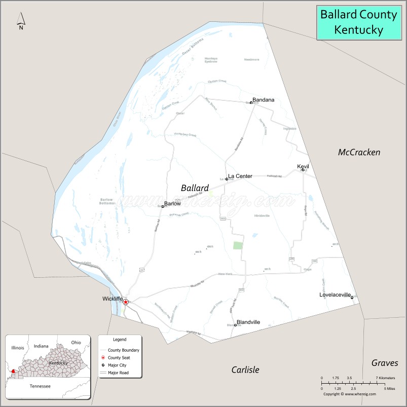
About Ballard County Map, Kentucky: The map showing the county boundary, county seat, major cities, highways, water bodies and neighbouring counties.
More Kentucky Maps & Info
Map of Ballard County, Kentucky
Ballard County is a county located in the U.S. state of Kentucky. It's county seat is Wickliffe. As per 2020 census, the population of Ballard County is 7695 people and population density is square miles. According to the United States Census Bureau, the county has a total area of 251 sq mi (650 km2). Ballard County was established on 1842.
Ballard County Facts
| Continent | North America |
| Country | United States |
| State | Kentucky |
| County Seat | Wickliffe |
| Largest City/Town | Wickliffe |
| Established | 1842 |
| Total Area | 252 sq mi (653 sq km) |
| Land Area | 247 sq mi (640 sq km) |
| Water Area | 5 sq mi (13 sq km) |
| Population | 7,728 (Census 2020) |
| Population Density | 31 people per sq mi |
| Time Zone | Central Time Zone (CT) |
| Major Highways | U.S. Route 51, U.S. Route 60, KY Route 286, KY Route 121 |
| Major Rivers | Ohio River, Mississippi River |
| Neighboring Counties | McCracken County, Carlisle County, Mississippi County (MO), Pulaski County (IL), Alexander County (IL) |
| Famous For | Confluence of the Ohio and Mississippi Rivers, Wickliffe Mounds, wetlands, and bird migration areas |
| Top Attractions | Wickliffe Mounds State Historic Site, Columbus-Belmont State Park nearby area, Ballard Wildlife Management Area, Fort Jefferson Hill Park, Ohio River scenery |
| Official Website | Official Website |
About Ballard County, Kentucky
Ballard County is located in the westernmost part of Kentucky near the confluence of the Ohio and Mississippi Rivers and was established in 1842. The county seat and largest city is Wickliffe. Ballard County is known for its river history, wetlands, wildlife habitats, and archaeological significance at Wickliffe Mounds. ([en.wikipedia.org](https://en.wikipedia.org/wiki/Ballard_County%2C_Kentucky?utm_source=chatgpt.com))
Cities and Communities in Ballard County, Kentucky
| City/Town | Population | Latitude & Longitude |
|---|---|---|
| Wickliffe (county seat) | 674+ | 36.9645°N, 89.0895°W |
| Barlow | 640+ | 37.0501°N, 89.0459°W |
| La Center | 900+ | 37.0737°N, 88.9737°W |
| Lovelaceville | Unincorporated | 37.1023°N, 88.8264°W |
| Kevil | Nearby Area | 37.0817°N, 88.8870°W |
| Bandana | Unincorporated | 37.1420°N, 88.9439°W |
| Oscar | Historic Community | 36.9987°N, 89.0724°W |
| New Liberty | Unincorporated | 37.0305°N, 89.1051°W |
Best Golf Courses in Ballard County, Kentucky
| Golf Course | Location | Latitude & Longitude |
|---|---|---|
| Paxton Park Golf Course | Nearby Paducah | 37.0730°N, 88.6557°W |
| Drake Creek Golf Club | Nearby Ledbetter | 37.0428°N, 88.4741°W |
| Rolling Hills Country Club | Nearby Salem | 37.2649°N, 88.2480°W |
What are Major Roads and Highways in Ballard County
Major highways provide access across western Kentucky and neighboring river states.
- U.S. Route 51 - north-south highway connecting Wickliffe with Illinois and Tennessee
- U.S. Route 60 - east-west route linking Ballard County with Paducah and western Kentucky communities
- KY Route 286 - local connector route serving agricultural and rural communities
- KY Route 121 - regional highway connecting western Kentucky river counties
Neighboring Counties of Ballard County
- McCracken County (east)
- Carlisle County (south)
- Mississippi County, Missouri (west)
- Pulaski County, Illinois (northwest)
- Alexander County, Illinois (north)
What are Top Attractions in Ballard County, Kentucky
The county features archaeological sites, wetlands, and riverfront scenery.
| Main Sight Name | City | Famous For |
|---|---|---|
| Wickliffe Mounds State Historic Site | Wickliffe | Mississippian Native American archaeological site |
| Ballard Wildlife Management Area | Countywide | Bird watching, wetlands, and hunting |
| Fort Jefferson Hill Park | Wickliffe | Historic river overlook and Civil War history |
| Ohio River Scenic Area | Wickliffe | River views and recreation |
| Mississippi River Confluence Area | Ballard County | Geographic meeting point of major rivers |
| Columbus-Belmont State Park Nearby Area | Nearby Columbus | Civil War history and Mississippi River overlooks |
| Downtown Wickliffe | Wickliffe | Historic courthouse and local shops |
| Bird Migration Observation Areas | Countywide | Seasonal waterfowl and wildlife viewing |
| Ballard County River Bottoms | Countywide | Scenic agricultural landscapes and wetlands |
| La Center Community Park | La Center | Local recreation and community events |
Distance from Ballard County to Nearby Cities
The following distances are measured by road (driving).
- Wickliffe to Paducah, Kentucky - 27 mi (43 km)
- Wickliffe to Cairo, Illinois - 18 mi (29 km)
- Wickliffe to Cape Girardeau, Missouri - 67 mi (108 km)
- Wickliffe to Mayfield, Kentucky - 42 mi (68 km)
- Wickliffe to Murray, Kentucky - 56 mi (90 km)
- Wickliffe to Metropolis, Illinois - 33 mi (53 km)
- Wickliffe to Nashville, Tennessee - 170 mi (274 km)
- Wickliffe to Evansville, Indiana - 118 mi (190 km)
- Wickliffe to St. Louis, Missouri - 155 mi (249 km)
- Wickliffe to Hopkinsville, Kentucky - 108 mi (174 km)
- Wickliffe to Louisville, Kentucky - 241 mi (388 km)
- Wickliffe to Memphis, Tennessee - 169 mi (272 km)
References
- Ballard County Official Website
- Ballard County, Kentucky - Wikipedia
- United States Census Bureau
- Kentucky Atlas and Gazetteer
- Wickliffe Mounds State Historic Site
- Adair County Map
- Allen County Map
- Anderson County Map
- Ballard County Map
- Barren County Map
- Bath County Map
- Bell County Map
- Boone County Map
- Bourbon County Map
- Boyd County Map
- Boyle County Map
- Bracken County Map
- Breathitt County Map
- Breckinridge County Map
- Bullitt County Map
- Butler County Map
- Caldwell County Map
- Calloway County Map
- Campbell County Map
- Carlisle County Map
- Carroll County Map
- Carter County Map
- Casey County Map
- Christian County Map
- Clark County Map
- Clay County Map
- Clinton County Map
- Crittenden County Map
- Cumberland County Map
- Daviess County Map
- Edmonson County Map
- Elliott County Map
- Estill County Map
- Fayette County Map
- Fleming County Map
- Floyd County Map
- Franklin County Map
- Fulton County Map
- Gallatin County Map
- Garrard County Map
- Grant County Map
- Graves County Map
- Grayson County Map
- Green County Map
- Greenup County Map
- Hancock County Map
- Hardin County Map
- Harlan County Map
- Harrison County Map
- Hart County Map
- Henderson County Map
- Henry County Map
- Hickman County Map
- Hopkins County Map
- Jackson County Map
- Jefferson County Map
- Jessamine County Map
- Johnson County Map
- Kenton County Map
- Knott County Map
- Knox County Map
- LaRue County Map
- Laurel County Map
- Lawrence County Map
- Lee County Map
- Leslie County Map
- Letcher County Map
- Lewis County Map
- Lincoln County Map
- Livingston County Map
- Logan County Map
- Lyon County Map
- McCracken County Map
- McCreary County Map
- McLean County Map
- Madison County Map
- Magoffin County Map
- Marion County Map
- Marshall County Map
- Martin County Map
- Mason County Map
- Meade County Map
- Menifee County Map
- Mercer County Map
- Metcalfe County Map
- Monroe County Map
- Montgomery County Map
- Morgan County Map
- Muhlenberg County Map
- Nelson County Map
- Nicholas County Map
- Ohio County Map
- Oldham County Map
- Owen County Map
- Owsley County Map
- Pendleton County Map
- Perry County Map
- Pike County Map
- Powell County Map
- Pulaski County Map
- Robertson County Map
- Rockcastle County Map
- Rowan County Map
- Russell County Map
- Scott County Map
- Shelby County Map
- Simpson County Map
- Spencer County Map
- Taylor County Map
- Todd County Map
- Trigg County Map
- Trimble County Map
- Union County Map
- Warren County Map
- Washington County Map
- Wayne County Map
- Webster County Map
- Whitley County Map
- Wolfe County Map
- Woodford County Map
- Alabama Counties
- Alaska boroughs
- Arizona Counties
- Arkansas Counties
- California County Map
- Colorado Counties
- Connecticut Counties
- Delaware Counties
- Florida County Map
- Georgia County Map
- Hawaii Counties
- Idaho Counties
- Illinois Counties
- Indiana Counties
- Iowa Counties
- Kansas Counties
- Kentucky Counties
- Louisiana Counties
- Maine Counties
- Maryland Counties
- Massachusetts Counties
- Michigan County Map
- Minnesota Counties
- Mississippi Counties
- Missouri Counties
- Montana Counties
- Nebraska Counties
- Nevada Counties
- New York Counties
- New Hampshire Counties
- New Jersey Counties
- New Mexico Counties
- North Carolina Counties
- North Dakota Counties
- Ohio County Map
- Oklahoma Counties
- Oregon Counties
- Pennsylvania Counties
- Rhode Island Counties
- South Carolina Counties
- South Dakota Counties
- Map of Tennessee
- Texas County Map
- Utah Counties
- Vermont Counties
- Virginia Counties
- Washington Counties
- West Virginia Counties
- Wisconsin Counties
- Wyoming Counties