Map of Letcher County - Letcher County is a county located in the U.S. state of Kentucky. Letcher County Map showing cities, highways, important places and water bodies. Get Where is Letcher County located in the map, major cities in Letcher county, population, areas, and places of interest.
Map of Letcher County, Kentucky
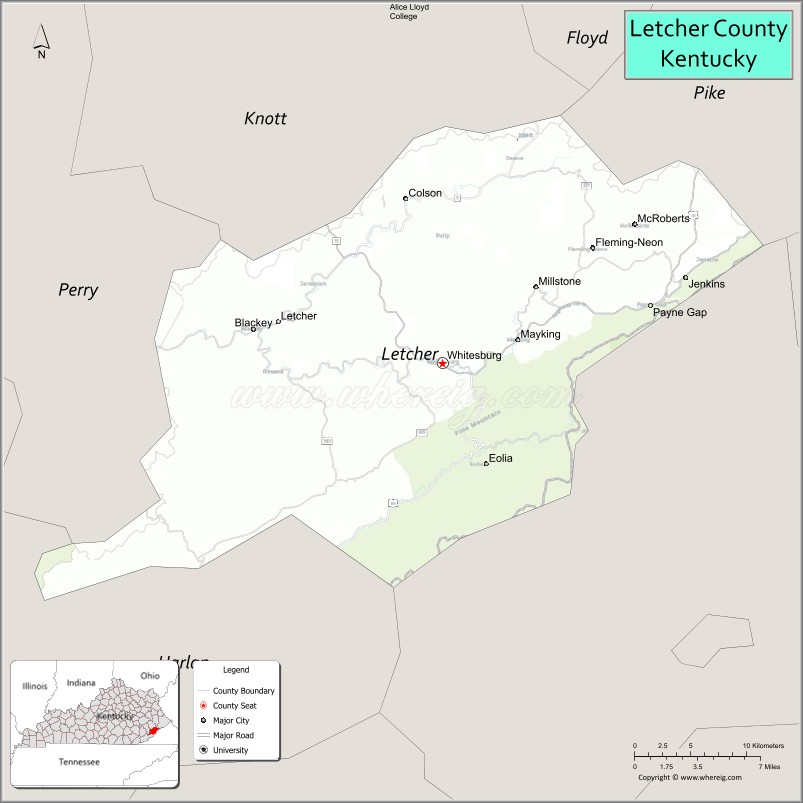
About Letcher County Map, Kentucky: The map showing the county boundary, county seat, major cities, highways, water bodies and neighbouring counties.
More Kentucky Maps & Info
Map of Letcher County, Kentucky
Letcher County is a county located in the U.S. state of Kentucky. It's county seat is Whitesburg. As per 2020 census, the population of Letcher County is 21253 people and population density is square miles. According to the United States Census Bureau, the county has a total area of 339 sq mi (878 km2). Letcher County was established on 1842.
Letcher County Facts
| Continent | North America |
| Country | United States |
| State | Kentucky |
| County Seat | Whitesburg |
| Largest City/Town | Jenkins |
| Established | 1842 |
| Total Area | 339 sq mi (878 sq km) |
| Land Area | 338 sq mi (875 sq km) |
| Water Area | 1.1 sq mi (3 sq km) |
| Population | 21,548 (Census 2020) |
| Population Density | 64 people per sq mi |
| Time Zone | Eastern Time Zone (ET) |
| Major Highways | U.S. Route 23, U.S. Route 119, Kentucky Route 15, Kentucky Route 805 |
| Major Rivers | North Fork Kentucky River, Poor Fork Cumberland River |
| Neighboring Counties | Perry County, Knott County, Harlan County, Pike County, Wise County (VA) |
| Famous For | Appalachian culture, coal mining heritage, mountain music, Appalshop, and scenic mountain landscapes |
| Top Attractions | Kingdom Come State Park nearby area, Appalshop, Bad Branch Falls, Whitesburg Historic District, Pine Mountain scenery |
| Official Website | Official Website |
About Letcher County, Kentucky
Letcher County is located in southeastern Kentucky within the Appalachian Mountains and was established in 1842 from parts of Harlan and Perry counties. The county seat is Whitesburg, while Jenkins is the largest city. Letcher County is known for Appalachian music and arts, coal mining history, mountain festivals, scenic valleys, and cultural organizations such as Appalshop. :contentReference[oaicite:0]{index=0}
Cities and Communities in Letcher County, Kentucky
| City/Town | Population | Latitude & Longitude |
|---|---|---|
| Whitesburg (county seat) | 1,600+ | 37.1184°N, 82.8260°W |
| Jenkins | 1,900+ | 37.1737°N, 82.6385°W |
| Fleming-Neon | 500+ | 37.1904°N, 82.7140°W |
| Blackey | Historic Community | 37.1406°N, 82.9818°W |
| Mayking | Census-Designated Place | 37.1415°N, 82.7646°W |
| McRoberts | Historic Mining Community | 37.2153°N, 82.6743°W |
| Millstone | Rural Community | 37.1795°N, 82.7696°W |
| Isom | Unincorporated | 37.1917°N, 82.8732°W |
Best Golf Courses in Letcher County, Kentucky
| Golf Course | Location | Latitude & Longitude |
|---|---|---|
| Pine Mountain Golf Course | Jenkins Area | 37.1834°N, 82.6322°W |
| Sleepy Hollow Golf Course | Nearby Cumberland | 36.9770°N, 82.9986°W |
| Eagle Ridge Golf Course | Nearby Prestonsburg | 37.6760°N, 82.7688°W |
| StoneCrest Golf Course | Nearby Prestonsburg | 37.6941°N, 82.7712°W |
What are Major Roads and Highways in Letcher County
Major highways connect Letcher County with Appalachian Kentucky, Virginia, and regional coalfield communities.
- U.S. Route 23 - major transportation corridor through eastern Kentucky coal country
- U.S. Route 119 - important highway connecting Jenkins, Whitesburg, and Harlan County
- Kentucky Route 15 - regional roadway linking Whitesburg with nearby mountain communities
- Kentucky Route 805 - scenic mountain connector route through rural areas
Neighboring Counties of Letcher County
- Perry County (west)
- Knott County (northwest)
- Harlan County (southwest)
- Pike County (northeast)
- Wise County, Virginia (east)
What are Top Attractions in Letcher County, Kentucky
The county offers Appalachian heritage sites, waterfalls, mountain recreation, music festivals, and scenic outdoor destinations.
| Main Sight Name | City | Famous For |
|---|---|---|
| Kingdom Come State Park Nearby Area | Regional Area | Mountain overlooks, hiking, and rock formations |
| Appalshop | Whitesburg | Appalachian arts, music, and film center |
| Bad Branch Falls | Pine Mountain Area | Scenic waterfall and nature preserve |
| Whitesburg Historic District | Whitesburg | Historic buildings and Appalachian culture |
| Pine Mountain Scenic Areas | Countywide | Mountain landscapes and hiking trails |
| Seedtime on the Cumberland Festival | Whitesburg | Traditional mountain crafts and music |
| Mountain Heritage Festival | Whitesburg | Local arts, crafts, and cultural events |
| Coal Mining Heritage Areas | Countywide | Mining history and Appalachian traditions |
| Jenkins Downtown Area | Jenkins | Historic coal town atmosphere |
| Daniel Boone National Forest Nearby Area | Regional Area | Outdoor recreation and scenic wilderness |
Distance from Letcher County to Nearby Cities
The following distances are measured by road (driving).
- Whitesburg to Hazard, Kentucky - 41 mi (66 km)
- Whitesburg to Pikeville, Kentucky - 58 mi (93 km)
- Whitesburg to Lexington, Kentucky - 146 mi (235 km)
- Whitesburg to Knoxville, Tennessee - 154 mi (248 km)
- Whitesburg to Charleston, West Virginia - 175 mi (282 km)
- Whitesburg to Louisville, Kentucky - 225 mi (362 km)
- Whitesburg to Cincinnati, Ohio - 236 mi (380 km)
- Whitesburg to Nashville, Tennessee - 282 mi (454 km)
- Whitesburg to Columbus, Ohio - 255 mi (410 km)
- Whitesburg to Indianapolis, Indiana - 330 mi (531 km)
- Whitesburg to Atlanta, Georgia - 319 mi (513 km)
- Whitesburg to Charlotte, North Carolina - 269 mi (433 km)
References
- Letcher County Official Website
- Letcher County, Kentucky - Wikipedia
- U.S. Census Bureau QuickFacts
- Advisory Council on Historic Preservation
- Kentucky Tourism
- Adair County Map
- Allen County Map
- Anderson County Map
- Ballard County Map
- Barren County Map
- Bath County Map
- Bell County Map
- Boone County Map
- Bourbon County Map
- Boyd County Map
- Boyle County Map
- Bracken County Map
- Breathitt County Map
- Breckinridge County Map
- Bullitt County Map
- Butler County Map
- Caldwell County Map
- Calloway County Map
- Campbell County Map
- Carlisle County Map
- Carroll County Map
- Carter County Map
- Casey County Map
- Christian County Map
- Clark County Map
- Clay County Map
- Clinton County Map
- Crittenden County Map
- Cumberland County Map
- Daviess County Map
- Edmonson County Map
- Elliott County Map
- Estill County Map
- Fayette County Map
- Fleming County Map
- Floyd County Map
- Franklin County Map
- Fulton County Map
- Gallatin County Map
- Garrard County Map
- Grant County Map
- Graves County Map
- Grayson County Map
- Green County Map
- Greenup County Map
- Hancock County Map
- Hardin County Map
- Harlan County Map
- Harrison County Map
- Hart County Map
- Henderson County Map
- Henry County Map
- Hickman County Map
- Hopkins County Map
- Jackson County Map
- Jefferson County Map
- Jessamine County Map
- Johnson County Map
- Kenton County Map
- Knott County Map
- Knox County Map
- LaRue County Map
- Laurel County Map
- Lawrence County Map
- Lee County Map
- Leslie County Map
- Letcher County Map
- Lewis County Map
- Lincoln County Map
- Livingston County Map
- Logan County Map
- Lyon County Map
- McCracken County Map
- McCreary County Map
- McLean County Map
- Madison County Map
- Magoffin County Map
- Marion County Map
- Marshall County Map
- Martin County Map
- Mason County Map
- Meade County Map
- Menifee County Map
- Mercer County Map
- Metcalfe County Map
- Monroe County Map
- Montgomery County Map
- Morgan County Map
- Muhlenberg County Map
- Nelson County Map
- Nicholas County Map
- Ohio County Map
- Oldham County Map
- Owen County Map
- Owsley County Map
- Pendleton County Map
- Perry County Map
- Pike County Map
- Powell County Map
- Pulaski County Map
- Robertson County Map
- Rockcastle County Map
- Rowan County Map
- Russell County Map
- Scott County Map
- Shelby County Map
- Simpson County Map
- Spencer County Map
- Taylor County Map
- Todd County Map
- Trigg County Map
- Trimble County Map
- Union County Map
- Warren County Map
- Washington County Map
- Wayne County Map
- Webster County Map
- Whitley County Map
- Wolfe County Map
- Woodford County Map
- Alabama Counties
- Alaska boroughs
- Arizona Counties
- Arkansas Counties
- California County Map
- Colorado Counties
- Connecticut Counties
- Delaware Counties
- Florida County Map
- Georgia County Map
- Hawaii Counties
- Idaho Counties
- Illinois Counties
- Indiana Counties
- Iowa Counties
- Kansas Counties
- Kentucky Counties
- Louisiana Counties
- Maine Counties
- Maryland Counties
- Massachusetts Counties
- Michigan County Map
- Minnesota Counties
- Mississippi Counties
- Missouri Counties
- Montana Counties
- Nebraska Counties
- Nevada Counties
- New York Counties
- New Hampshire Counties
- New Jersey Counties
- New Mexico Counties
- North Carolina Counties
- North Dakota Counties
- Ohio County Map
- Oklahoma Counties
- Oregon Counties
- Pennsylvania Counties
- Rhode Island Counties
- South Carolina Counties
- South Dakota Counties
- Map of Tennessee
- Texas County Map
- Utah Counties
- Vermont Counties
- Virginia Counties
- Washington Counties
- West Virginia Counties
- Wisconsin Counties
- Wyoming Counties