Map of Cumberland County - Cumberland County is a county located in the U.S. state of Kentucky. Cumberland County Map showing cities, highways, important places and water bodies. Get Where is Cumberland County located in the map, major cities in Cumberland county, population, areas, and places of interest.
Map of Cumberland County, Kentucky
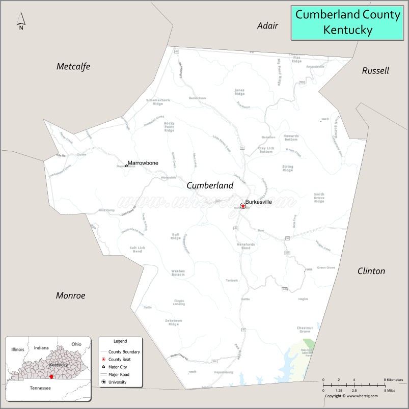
About Cumberland County Map, Kentucky: The map showing the county boundary, county seat, major cities, highways, water bodies and neighbouring counties.
More Kentucky Maps & Info
Map of Cumberland County, Kentucky
Cumberland County is a county located in the U.S. state of Kentucky. It's county seat is Burkesville. As per 2020 census, the population of Cumberland County is 5879 people and population density is square miles. According to the United States Census Bureau, the county has a total area of 306 sq mi (793 km2). Cumberland County was established on 1798.
Cumberland County Facts
| Continent | North America |
| Country | United States |
| State | Kentucky |
| County Seat | Burkesville |
| Largest City/Town | Burkesville |
| Established | 1798 |
| Total Area | 311 sq mi (806 sq km) |
| Land Area | 305 sq mi (790 sq km) |
| Water Area | 5.7 sq mi (15 sq km) |
| Population | 5,888 (Census 2020) |
| Population Density | 19 people per sq mi |
| Time Zone | Central Time Zone (CT) |
| Major Highways | Kentucky Route 90, Kentucky Route 61, Kentucky Route 704, U.S. Route 127 nearby area |
| Major Rivers | Cumberland River, Marrowbone Creek, Dale Hollow Lake nearby area |
| Neighboring Counties | Adair County, Clinton County, Metcalfe County, Monroe County, Russell County, Clay County (TN) |
| Famous For | Dale Hollow Lake, Cumberland River recreation, fishing, boating, and rural Kentucky landscapes |
| Top Attractions | Dale Hollow Lake nearby area, Cumberland River, Burkesville Historic District, Dale Hollow State Resort Park nearby area, fishing and boating recreation |
| Official Website | Official Website |
About Cumberland County, Kentucky
Cumberland County is located in south-central Kentucky within the Pennyroyal Plateau region near the Tennessee border and was established in 1798. The county seat and largest city is Burkesville. Cumberland County is known for its scenic countryside, outdoor recreation around Dale Hollow Lake and the Cumberland River, fishing destinations, and rural Kentucky heritage. :contentReference[oaicite:0]{index=0}
Cities and Communities in Cumberland County, Kentucky
| City/Town | Population | Latitude & Longitude |
|---|---|---|
| Burkesville (county seat) | 1,400+ | 36.7909°N, 85.3708°W |
| Marrowbone | Census Community | 36.8387°N, 85.4130°W |
| Grider | Unincorporated | 36.6612°N, 85.3827°W |
| Kettle | Unincorporated | 36.8421°N, 85.2814°W |
| Peytonsburg | Historic Community | 36.8760°N, 85.2931°W |
| Waterview | Unincorporated | 36.7488°N, 85.3479°W |
| Modoc | Unincorporated | 36.7219°N, 85.4351°W |
| Frogue | Historic Community | 36.6744°N, 85.2558°W |
Best Golf Courses in Cumberland County, Kentucky
| Golf Course | Location | Latitude & Longitude |
|---|---|---|
| Dale Hollow Lake State Resort Park Golf Course | Nearby Burkesville | 36.6418°N, 85.3061°W |
| Lakewood Country Club | Nearby Russell Springs | 37.0591°N, 85.0924°W |
| Southern Hills Golf Course | Nearby Cookeville, Tennessee | 36.1804°N, 85.5019°W |
| Hidden Valley Golf Course | Nearby Livingston, Tennessee | 36.3878°N, 85.3360°W |
What are Major Roads and Highways in Cumberland County
Major highways connect Cumberland County with south-central Kentucky, Tennessee, and nearby lake recreation areas.
- Kentucky Route 90 - major east-west route through Burkesville and nearby lake regions
- Kentucky Route 61 - important north-south route connecting rural communities
- Kentucky Route 704 - scenic roadway serving farming and recreational areas
- U.S. Route 127 nearby area - regional transportation corridor through south-central Kentucky
Neighboring Counties of Cumberland County
- Adair County (north)
- Clinton County (east)
- Metcalfe County (west)
- Monroe County (southwest)
- Russell County (northeast)
- Clay County, Tennessee (south)
What are Top Attractions in Cumberland County, Kentucky
The county offers outdoor recreation, scenic rivers, fishing destinations, and countryside attractions.
| Main Sight Name | City | Famous For |
|---|---|---|
| Dale Hollow Lake Nearby Area | Southern County Area | Fishing, boating, and houseboat recreation |
| Cumberland River | Countywide | Fishing, kayaking, and scenic river landscapes |
| Burkesville Historic District | Burkesville | Historic downtown buildings and local shops |
| Dale Hollow Lake State Resort Park Nearby Area | Regional Area | Camping, golf, and lake recreation |
| Fishing and Marina Areas | Countywide | Outdoor recreation and boating access |
| Marrowbone Creek Scenic Area | Countywide | Nature scenery and rural landscapes |
| Cumberland County Courthouse | Burkesville | Historic county landmark |
| Scenic Farm Drives | Countywide | Rolling hills and countryside views |
| Wolf Creek Recreation Nearby Area | Regional Area | Camping and outdoor activities |
| Local Community Festivals | Burkesville Area | Traditional Kentucky events and fairs |
Distance from Cumberland County to Nearby Cities
The following distances are measured by road (driving).
- Burkesville to Russell Springs, Kentucky - 28 mi (45 km)
- Burkesville to Somerset, Kentucky - 52 mi (84 km)
- Burkesville to Bowling Green, Kentucky - 82 mi (132 km)
- Burkesville to Cookeville, Tennessee - 55 mi (89 km)
- Burkesville to Nashville, Tennessee - 113 mi (182 km)
- Burkesville to Lexington, Kentucky - 126 mi (203 km)
- Burkesville to Louisville, Kentucky - 151 mi (243 km)
- Burkesville to Knoxville, Tennessee - 132 mi (212 km)
- Burkesville to Chattanooga, Tennessee - 198 mi (319 km)
- Burkesville to Cincinnati, Ohio - 214 mi (344 km)
- Burkesville to Indianapolis, Indiana - 231 mi (372 km)
- Burkesville to Memphis, Tennessee - 286 mi (460 km)
References
- Cumberland County Official Website
- Cumberland County, Kentucky - Wikipedia
- U.S. Census Bureau QuickFacts
- Dale Hollow Lake State Resort Park
- Kentucky Hometown Locator
- Adair County Map
- Allen County Map
- Anderson County Map
- Ballard County Map
- Barren County Map
- Bath County Map
- Bell County Map
- Boone County Map
- Bourbon County Map
- Boyd County Map
- Boyle County Map
- Bracken County Map
- Breathitt County Map
- Breckinridge County Map
- Bullitt County Map
- Butler County Map
- Caldwell County Map
- Calloway County Map
- Campbell County Map
- Carlisle County Map
- Carroll County Map
- Carter County Map
- Casey County Map
- Christian County Map
- Clark County Map
- Clay County Map
- Clinton County Map
- Crittenden County Map
- Cumberland County Map
- Daviess County Map
- Edmonson County Map
- Elliott County Map
- Estill County Map
- Fayette County Map
- Fleming County Map
- Floyd County Map
- Franklin County Map
- Fulton County Map
- Gallatin County Map
- Garrard County Map
- Grant County Map
- Graves County Map
- Grayson County Map
- Green County Map
- Greenup County Map
- Hancock County Map
- Hardin County Map
- Harlan County Map
- Harrison County Map
- Hart County Map
- Henderson County Map
- Henry County Map
- Hickman County Map
- Hopkins County Map
- Jackson County Map
- Jefferson County Map
- Jessamine County Map
- Johnson County Map
- Kenton County Map
- Knott County Map
- Knox County Map
- LaRue County Map
- Laurel County Map
- Lawrence County Map
- Lee County Map
- Leslie County Map
- Letcher County Map
- Lewis County Map
- Lincoln County Map
- Livingston County Map
- Logan County Map
- Lyon County Map
- McCracken County Map
- McCreary County Map
- McLean County Map
- Madison County Map
- Magoffin County Map
- Marion County Map
- Marshall County Map
- Martin County Map
- Mason County Map
- Meade County Map
- Menifee County Map
- Mercer County Map
- Metcalfe County Map
- Monroe County Map
- Montgomery County Map
- Morgan County Map
- Muhlenberg County Map
- Nelson County Map
- Nicholas County Map
- Ohio County Map
- Oldham County Map
- Owen County Map
- Owsley County Map
- Pendleton County Map
- Perry County Map
- Pike County Map
- Powell County Map
- Pulaski County Map
- Robertson County Map
- Rockcastle County Map
- Rowan County Map
- Russell County Map
- Scott County Map
- Shelby County Map
- Simpson County Map
- Spencer County Map
- Taylor County Map
- Todd County Map
- Trigg County Map
- Trimble County Map
- Union County Map
- Warren County Map
- Washington County Map
- Wayne County Map
- Webster County Map
- Whitley County Map
- Wolfe County Map
- Woodford County Map
- Alabama Counties
- Alaska boroughs
- Arizona Counties
- Arkansas Counties
- California County Map
- Colorado Counties
- Connecticut Counties
- Delaware Counties
- Florida County Map
- Georgia County Map
- Hawaii Counties
- Idaho Counties
- Illinois Counties
- Indiana Counties
- Iowa Counties
- Kansas Counties
- Kentucky Counties
- Louisiana Counties
- Maine Counties
- Maryland Counties
- Massachusetts Counties
- Michigan County Map
- Minnesota Counties
- Mississippi Counties
- Missouri Counties
- Montana Counties
- Nebraska Counties
- Nevada Counties
- New York Counties
- New Hampshire Counties
- New Jersey Counties
- New Mexico Counties
- North Carolina Counties
- North Dakota Counties
- Ohio County Map
- Oklahoma Counties
- Oregon Counties
- Pennsylvania Counties
- Rhode Island Counties
- South Carolina Counties
- South Dakota Counties
- Map of Tennessee
- Texas County Map
- Utah Counties
- Vermont Counties
- Virginia Counties
- Washington Counties
- West Virginia Counties
- Wisconsin Counties
- Wyoming Counties