Map of Greenup County - Greenup County is a county located in the U.S. state of Kentucky. Greenup County Map showing cities, highways, important places and water bodies. Get Where is Greenup County located in the map, major cities in Greenup county, population, areas, and places of interest.
Map of Greenup County, Kentucky
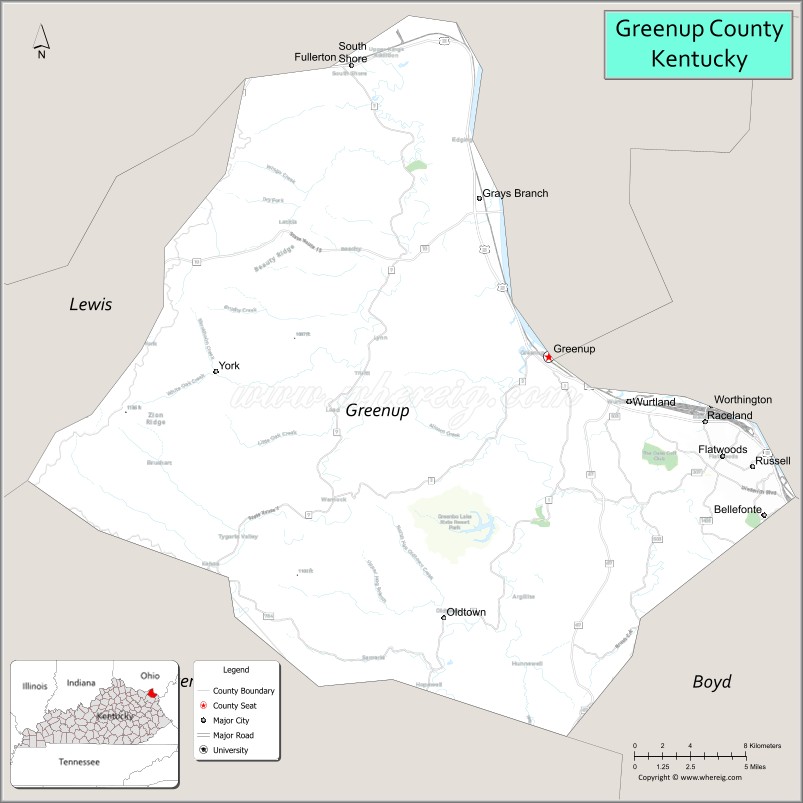
About Greenup County Map, Kentucky: The map showing the county boundary, county seat, major cities, highways, water bodies and neighbouring counties.
More Kentucky Maps & Info
Map of Greenup County, Kentucky
Greenup County is a county located in the U.S. state of Kentucky. It's county seat is Greenup. As per 2020 census, the population of Greenup County is 35649 people and population density is square miles. According to the United States Census Bureau, the county has a total area of 346 sq mi (896 km2). Greenup County was established on 1803.
Greenup County Facts
| Continent | North America |
| Country | United States |
| State | Kentucky |
| County Seat | Greenup |
| Largest City/Town | Flatwoods |
| Established | 1803 |
| Total Area | 354 sq mi (917 sq km) |
| Land Area | 344 sq mi (891 sq km) |
| Water Area | 10 sq mi (26 sq km) |
| Population | 35,962 (Census 2020) |
| Population Density | 104 people per sq mi |
| Time Zone | Eastern Time Zone (ET) |
| Major Highways | Interstate 64, U.S. Route 23, U.S. Route 60, Kentucky Route 7 |
| Major Rivers | Ohio River, Little Sandy River |
| Neighboring Counties | Boyd County, Carter County, Lewis County, Scioto County (OH) |
| Famous For | Ohio River industries, Greenbo Lake State Resort Park, Appalachian foothills, and riverfront communities |
| Top Attractions | Greenbo Lake State Resort Park, Jesse Stuart Lodge, Flatwoods City Park, Historic Greenup Riverfront, Ohio River scenic areas |
| Official Website | Official Website |
About Greenup County, Kentucky
Greenup County is located in northeastern Kentucky along the Ohio River and was established in 1803. The county seat is Greenup, while Flatwoods is the largest city. Greenup County is known for its scenic river landscapes, Appalachian foothills, industrial heritage, outdoor recreation, and access to Greenbo Lake State Resort Park. ([en.wikipedia.org](https://en.wikipedia.org/wiki/Greenup_County%2C_Kentucky?utm_source=chatgpt.com))
Cities and Communities in Greenup County, Kentucky
| City/Town | Population | Latitude & Longitude |
|---|---|---|
| Flatwoods | 7,400+ | 38.5226°N, 82.7260°W |
| Greenup (county seat) | 1,200+ | 38.5734°N, 82.8302°W |
| Russell | 3,300+ | 38.5295°N, 82.6943°W |
| South Shore | 1,000+ | 38.7203°N, 82.9585°W |
| Worthington | 1,600+ | 38.5501°N, 82.7388°W |
| Raceland | 2,200+ | 38.5384°N, 82.7299°W |
| Wurtland | 1,400+ | 38.5495°N, 82.7963°W |
| Lloyd | Unincorporated | 38.6948°N, 82.9477°W |
Best Golf Courses in Greenup County, Kentucky
| Golf Course | Location | Latitude & Longitude |
|---|---|---|
| Sandy Creek Golf Course | Greenup | 38.5838°N, 82.8191°W |
| River Bend Golf Club | Argillite Area | 38.6411°N, 82.8299°W |
| Diamond Links Golf Club | Nearby Catlettsburg | 38.4252°N, 82.6129°W |
| Hidden Cove Golf Course | Nearby Grayson | 38.3559°N, 82.9362°W |
What are Major Roads and Highways in Greenup County
Major highways connect Greenup County with Ohio, West Virginia, and eastern Kentucky communities.
- Interstate 64 - major interstate connecting northeastern Kentucky with Lexington and West Virginia
- U.S. Route 23 - important north-south corridor through eastern Kentucky and river communities
- U.S. Route 60 - scenic east-west route along the Ohio River corridor
- Kentucky Route 7 - regional highway serving Appalachian foothill communities
Neighboring Counties of Greenup County
- Boyd County (south)
- Carter County (southwest)
- Lewis County (west)
- Scioto County, Ohio (north across the Ohio River)
What are Top Attractions in Greenup County, Kentucky
The county offers lake recreation, riverfront scenery, parks, and outdoor Appalachian attractions.
| Main Sight Name | City | Famous For |
|---|---|---|
| Greenbo Lake State Resort Park | Greenup Area | Camping, fishing, boating, and hiking trails |
| Jesse Stuart Lodge | Greenbo Lake Area | Scenic lodge overlooking Greenbo Lake |
| Flatwoods City Park | Flatwoods | Community recreation and family events |
| Historic Greenup Riverfront | Greenup | Ohio River views and local history |
| Ohio River Scenic Areas | Countywide | River overlooks and photography opportunities |
| Little Sandy River Area | Countywide | Fishing and nature scenery |
| Downtown Russell | Russell | Restaurants and local businesses |
| Greenup County Museum | Greenup | Regional history and cultural exhibits |
| Appalachian Scenic Drives | Countywide | Rolling hills and countryside landscapes |
| Outdoor Recreation Areas | Countywide | Hiking, camping, and wildlife observation |
Distance from Greenup County to Nearby Cities
The following distances are measured by road (driving).
- Greenup to Ashland, Kentucky - 15 mi (24 km)
- Flatwoods to Huntington, West Virginia - 22 mi (35 km)
- Greenup to Portsmouth, Ohio - 28 mi (45 km)
- Flatwoods to Charleston, West Virginia - 67 mi (108 km)
- Greenup to Lexington, Kentucky - 126 mi (203 km)
- Flatwoods to Cincinnati, Ohio - 152 mi (245 km)
- Greenup to Columbus, Ohio - 145 mi (233 km)
- Flatwoods to Louisville, Kentucky - 202 mi (325 km)
- Greenup to Knoxville, Tennessee - 221 mi (356 km)
- Flatwoods to Indianapolis, Indiana - 255 mi (410 km)
- Greenup to Nashville, Tennessee - 301 mi (484 km)
- Flatwoods to Chicago, Illinois - 392 mi (631 km)
References
- Greenup County Official Website
- Greenup County, Kentucky - Wikipedia
- U.S. Census Bureau QuickFacts
- Greenbo Lake State Resort Park
- Kentucky Tourism
- Adair County Map
- Allen County Map
- Anderson County Map
- Ballard County Map
- Barren County Map
- Bath County Map
- Bell County Map
- Boone County Map
- Bourbon County Map
- Boyd County Map
- Boyle County Map
- Bracken County Map
- Breathitt County Map
- Breckinridge County Map
- Bullitt County Map
- Butler County Map
- Caldwell County Map
- Calloway County Map
- Campbell County Map
- Carlisle County Map
- Carroll County Map
- Carter County Map
- Casey County Map
- Christian County Map
- Clark County Map
- Clay County Map
- Clinton County Map
- Crittenden County Map
- Cumberland County Map
- Daviess County Map
- Edmonson County Map
- Elliott County Map
- Estill County Map
- Fayette County Map
- Fleming County Map
- Floyd County Map
- Franklin County Map
- Fulton County Map
- Gallatin County Map
- Garrard County Map
- Grant County Map
- Graves County Map
- Grayson County Map
- Green County Map
- Greenup County Map
- Hancock County Map
- Hardin County Map
- Harlan County Map
- Harrison County Map
- Hart County Map
- Henderson County Map
- Henry County Map
- Hickman County Map
- Hopkins County Map
- Jackson County Map
- Jefferson County Map
- Jessamine County Map
- Johnson County Map
- Kenton County Map
- Knott County Map
- Knox County Map
- LaRue County Map
- Laurel County Map
- Lawrence County Map
- Lee County Map
- Leslie County Map
- Letcher County Map
- Lewis County Map
- Lincoln County Map
- Livingston County Map
- Logan County Map
- Lyon County Map
- McCracken County Map
- McCreary County Map
- McLean County Map
- Madison County Map
- Magoffin County Map
- Marion County Map
- Marshall County Map
- Martin County Map
- Mason County Map
- Meade County Map
- Menifee County Map
- Mercer County Map
- Metcalfe County Map
- Monroe County Map
- Montgomery County Map
- Morgan County Map
- Muhlenberg County Map
- Nelson County Map
- Nicholas County Map
- Ohio County Map
- Oldham County Map
- Owen County Map
- Owsley County Map
- Pendleton County Map
- Perry County Map
- Pike County Map
- Powell County Map
- Pulaski County Map
- Robertson County Map
- Rockcastle County Map
- Rowan County Map
- Russell County Map
- Scott County Map
- Shelby County Map
- Simpson County Map
- Spencer County Map
- Taylor County Map
- Todd County Map
- Trigg County Map
- Trimble County Map
- Union County Map
- Warren County Map
- Washington County Map
- Wayne County Map
- Webster County Map
- Whitley County Map
- Wolfe County Map
- Woodford County Map
- Alabama Counties
- Alaska boroughs
- Arizona Counties
- Arkansas Counties
- California County Map
- Colorado Counties
- Connecticut Counties
- Delaware Counties
- Florida County Map
- Georgia County Map
- Hawaii Counties
- Idaho Counties
- Illinois Counties
- Indiana Counties
- Iowa Counties
- Kansas Counties
- Kentucky Counties
- Louisiana Counties
- Maine Counties
- Maryland Counties
- Massachusetts Counties
- Michigan County Map
- Minnesota Counties
- Mississippi Counties
- Missouri Counties
- Montana Counties
- Nebraska Counties
- Nevada Counties
- New York Counties
- New Hampshire Counties
- New Jersey Counties
- New Mexico Counties
- North Carolina Counties
- North Dakota Counties
- Ohio County Map
- Oklahoma Counties
- Oregon Counties
- Pennsylvania Counties
- Rhode Island Counties
- South Carolina Counties
- South Dakota Counties
- Map of Tennessee
- Texas County Map
- Utah Counties
- Vermont Counties
- Virginia Counties
- Washington Counties
- West Virginia Counties
- Wisconsin Counties
- Wyoming Counties