Map of McCreary County - McCreary County is a county located in the U.S. state of Kentucky. McCreary County Map showing cities, highways, important places and water bodies. Get Where is McCreary County located in the map, major cities in McCreary county, population, areas, and places of interest.
Map of McCreary County, Kentucky
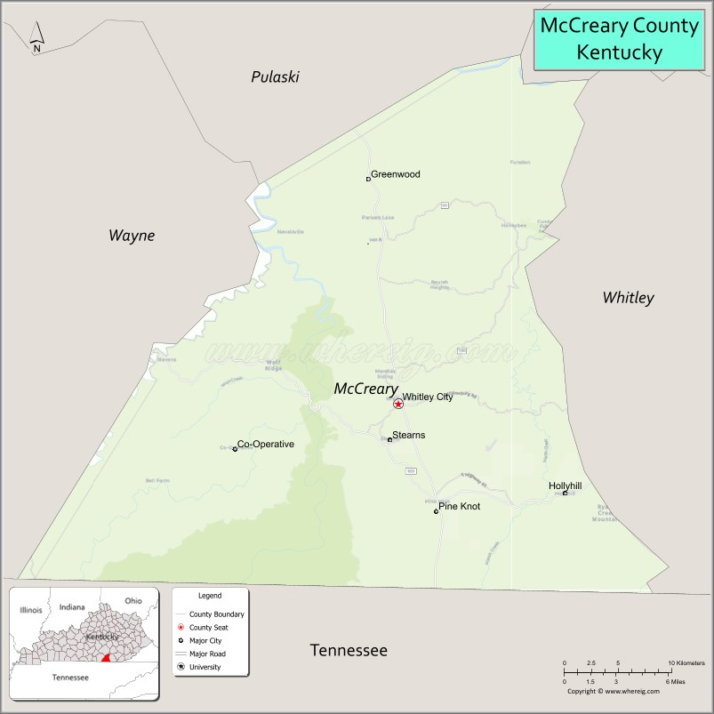
About McCreary County Map, Kentucky: The map showing the county boundary, county seat, major cities, highways, water bodies and neighbouring counties.
More Kentucky Maps & Info
Map of McCreary County, Kentucky
McCreary County is a county located in the U.S. state of Kentucky. It's county seat is Whitley City. As per 2020 census, the population of McCreary County is 16892 people and population density is square miles. According to the United States Census Bureau, the county has a total area of 428 sq mi (1,109 km2). McCreary County was established on 1912.
McCreary County Facts
| Continent | North America |
| Country | United States |
| State | Kentucky |
| County Seat | Whitley City |
| Largest City/Town | Pine Knot |
| Established | 1912 |
| Total Area | 431 sq mi (1,116 sq km) |
| Land Area | 427 sq mi (1,106 sq km) |
| Water Area | 4.1 sq mi (11 sq km) |
| Population | 16,888 (Census 2020) |
| Population Density | 40 people per sq mi |
| Time Zone | Eastern Time Zone (ET) |
| Major Highways | U.S. Route 27, Kentucky Route 92, Kentucky Route 90, Kentucky Route 1651 |
| Major Rivers | Cumberland River, Big South Fork Cumberland River |
| Neighboring Counties | Pulaski County, Laurel County, Whitley County, Wayne County, Scott County (TN), Campbell County (TN) |
| Famous For | Big South Fork National River and Recreation Area, Cumberland Falls nearby area, Daniel Boone National Forest, and Appalachian outdoor recreation |
| Top Attractions | Big South Fork National River and Recreation Area, Natural Arch Scenic Area, Blue Heron Mining Community, Yahoo Falls, McCreary County Museum |
| Official Website | Official Website |
About McCreary County, Kentucky
McCreary County is located in southeastern Kentucky along the Tennessee border and was established in 1912. The county seat is Whitley City, while Pine Knot is the largest community. McCreary County is known for rugged Appalachian landscapes, extensive forestlands, sandstone arches, waterfalls, and outdoor recreation throughout the Big South Fork National River and Recreation Area and Daniel Boone National Forest. :contentReference[oaicite:0]{index=0}
Cities and Communities in McCreary County, Kentucky
| City/Town | Population | Latitude & Longitude |
|---|---|---|
| Whitley City (county seat) | 1,200+ | 36.7237°N, 84.4702°W |
| Pine Knot | 1,300+ | 36.6501°N, 84.4388°W |
| Stearns | 1,500+ | 36.6984°N, 84.4779°W |
| Hill Top | Historic Community | 36.7229°N, 84.5302°W |
| Barthell | Historic Mining Community | 36.6241°N, 84.5243°W |
| Blue Heron | Historic Recreation Area | 36.6972°N, 84.5446°W |
| Marshes Siding | Rural Community | 36.6661°N, 84.4958°W |
| Parkers Lake | Residential Community | 36.7317°N, 84.4182°W |
Best Golf Courses in McCreary County, Kentucky
| Golf Course | Location | Latitude & Longitude |
|---|---|---|
| Whitley County Country Club | Nearby Williamsburg | 36.7417°N, 84.1596°W |
| Crooked Creek Golf Club | Nearby London | 37.0948°N, 84.0834°W |
| Lake Cumberland Golf Club | Nearby Russell Springs | 37.0701°N, 85.0883°W |
| General Burnside Island Golf Course | Nearby Burnside | 36.9906°N, 84.5997°W |
What are Major Roads and Highways in McCreary County
Major highways connect McCreary County with southeastern Kentucky, Tennessee, and regional Appalachian recreation destinations.
- U.S. Route 27 - major north-south transportation corridor through southeastern Kentucky
- Kentucky Route 92 - scenic roadway connecting Whitley City with forest and recreation areas
- Kentucky Route 90 - important route through mountain communities and tourism areas
- Kentucky Route 1651 - regional connector serving rural communities and park access
Neighboring Counties of McCreary County
- Pulaski County (north)
- Laurel County (northeast)
- Whitley County (east)
- Wayne County (west)
- Scott County, Tennessee (south)
- Campbell County, Tennessee (southeast)
What are Top Attractions in McCreary County, Kentucky
The county offers waterfalls, hiking trails, sandstone arches, historic mining communities, and outdoor recreation throughout the Appalachian Plateau region. :contentReference[oaicite:1]{index=1}
| Main Sight Name | City | Famous For |
|---|---|---|
| Big South Fork National River and Recreation Area | Countywide | Hiking, rafting, sandstone cliffs, and scenic wilderness |
| Natural Arch Scenic Area | Stearns Area | Massive sandstone arch and forest trails |
| Blue Heron Mining Community | Blue Heron | Historic coal mining ghost town exhibits |
| Yahoo Falls | Whitley City Area | Tall waterfall and nature trails |
| McCreary County Museum | Stearns | Regional Appalachian and coal mining history |
| Cumberland Falls Nearby Area | Regional Area | Waterfalls and famous moonbow views |
| Barthell Coal Mining Camp | Barthell | Historic restored mining settlement |
| Big South Fork Scenic Railway | Stearns | Historic railway excursions and mountain scenery |
| Eagle Falls Nearby Area | Regional Area | Waterfall hiking and photography |
| Daniel Boone National Forest | Countywide | Camping, hiking, wildlife viewing, and scenic drives |
Distance from McCreary County to Nearby Cities
The following distances are measured by road (driving).
- Whitley City to Somerset, Kentucky - 33 mi (53 km)
- Whitley City to Corbin, Kentucky - 36 mi (58 km)
- Whitley City to Knoxville, Tennessee - 79 mi (127 km)
- Whitley City to Lexington, Kentucky - 118 mi (190 km)
- Whitley City to Louisville, Kentucky - 188 mi (303 km)
- Whitley City to Chattanooga, Tennessee - 151 mi (243 km)
- Whitley City to Nashville, Tennessee - 201 mi (323 km)
- Whitley City to Cincinnati, Ohio - 191 mi (307 km)
- Whitley City to Atlanta, Georgia - 248 mi (399 km)
- Whitley City to Indianapolis, Indiana - 283 mi (455 km)
- Whitley City to Charleston, West Virginia - 240 mi (386 km)
- Whitley City to St. Louis, Missouri - 405 mi (652 km)
References
- McCreary County Official Website
- McCreary County, Kentucky - Wikipedia
- U.S. Census Bureau QuickFacts
- Big South Fork National River and Recreation Area
- Daniel Boone National Forest
- Adair County Map
- Allen County Map
- Anderson County Map
- Ballard County Map
- Barren County Map
- Bath County Map
- Bell County Map
- Boone County Map
- Bourbon County Map
- Boyd County Map
- Boyle County Map
- Bracken County Map
- Breathitt County Map
- Breckinridge County Map
- Bullitt County Map
- Butler County Map
- Caldwell County Map
- Calloway County Map
- Campbell County Map
- Carlisle County Map
- Carroll County Map
- Carter County Map
- Casey County Map
- Christian County Map
- Clark County Map
- Clay County Map
- Clinton County Map
- Crittenden County Map
- Cumberland County Map
- Daviess County Map
- Edmonson County Map
- Elliott County Map
- Estill County Map
- Fayette County Map
- Fleming County Map
- Floyd County Map
- Franklin County Map
- Fulton County Map
- Gallatin County Map
- Garrard County Map
- Grant County Map
- Graves County Map
- Grayson County Map
- Green County Map
- Greenup County Map
- Hancock County Map
- Hardin County Map
- Harlan County Map
- Harrison County Map
- Hart County Map
- Henderson County Map
- Henry County Map
- Hickman County Map
- Hopkins County Map
- Jackson County Map
- Jefferson County Map
- Jessamine County Map
- Johnson County Map
- Kenton County Map
- Knott County Map
- Knox County Map
- LaRue County Map
- Laurel County Map
- Lawrence County Map
- Lee County Map
- Leslie County Map
- Letcher County Map
- Lewis County Map
- Lincoln County Map
- Livingston County Map
- Logan County Map
- Lyon County Map
- McCracken County Map
- McCreary County Map
- McLean County Map
- Madison County Map
- Magoffin County Map
- Marion County Map
- Marshall County Map
- Martin County Map
- Mason County Map
- Meade County Map
- Menifee County Map
- Mercer County Map
- Metcalfe County Map
- Monroe County Map
- Montgomery County Map
- Morgan County Map
- Muhlenberg County Map
- Nelson County Map
- Nicholas County Map
- Ohio County Map
- Oldham County Map
- Owen County Map
- Owsley County Map
- Pendleton County Map
- Perry County Map
- Pike County Map
- Powell County Map
- Pulaski County Map
- Robertson County Map
- Rockcastle County Map
- Rowan County Map
- Russell County Map
- Scott County Map
- Shelby County Map
- Simpson County Map
- Spencer County Map
- Taylor County Map
- Todd County Map
- Trigg County Map
- Trimble County Map
- Union County Map
- Warren County Map
- Washington County Map
- Wayne County Map
- Webster County Map
- Whitley County Map
- Wolfe County Map
- Woodford County Map
- Alabama Counties
- Alaska boroughs
- Arizona Counties
- Arkansas Counties
- California County Map
- Colorado Counties
- Connecticut Counties
- Delaware Counties
- Florida County Map
- Georgia County Map
- Hawaii Counties
- Idaho Counties
- Illinois Counties
- Indiana Counties
- Iowa Counties
- Kansas Counties
- Kentucky Counties
- Louisiana Counties
- Maine Counties
- Maryland Counties
- Massachusetts Counties
- Michigan County Map
- Minnesota Counties
- Mississippi Counties
- Missouri Counties
- Montana Counties
- Nebraska Counties
- Nevada Counties
- New York Counties
- New Hampshire Counties
- New Jersey Counties
- New Mexico Counties
- North Carolina Counties
- North Dakota Counties
- Ohio County Map
- Oklahoma Counties
- Oregon Counties
- Pennsylvania Counties
- Rhode Island Counties
- South Carolina Counties
- South Dakota Counties
- Map of Tennessee
- Texas County Map
- Utah Counties
- Vermont Counties
- Virginia Counties
- Washington Counties
- West Virginia Counties
- Wisconsin Counties
- Wyoming Counties