Map of Mason County - Mason County is a county located in the U.S. state of Kentucky. Mason County Map showing cities, highways, important places and water bodies. Get Where is Mason County located in the map, major cities in Mason county, population, areas, and places of interest.
Map of Mason County, Kentucky
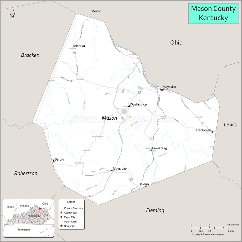
About Mason County Map, Kentucky: The map showing the county boundary, county seat, major cities, highways, water bodies and neighbouring counties.
More Kentucky Maps & Info
Map of Mason County, Kentucky
Mason County is a county located in the U.S. state of Kentucky. It's county seat is Maysville. As per 2020 census, the population of Mason County is 16931 people and population density is square miles. According to the United States Census Bureau, the county has a total area of 241 sq mi (624 km2). Mason County was established on 1788.
Mason County Facts
| Continent | North America |
| Country | United States |
| State | Kentucky |
| County Seat | Maysville |
| Largest City/Town | Maysville |
| Established | 1788 |
| Total Area | 246 sq mi (637 sq km) |
| Land Area | 240 sq mi (622 sq km) |
| Water Area | 6.1 sq mi (16 sq km) |
| Population | 17,120 (Census 2020) |
| Population Density | 71 people per sq mi |
| Time Zone | Eastern Time Zone (ET) |
| Major Highways | U.S. Route 68, U.S. Route 62, Kentucky Route 9 (AA Highway), Kentucky Route 10 |
| Major Rivers | Ohio River, Licking River |
| Neighboring Counties | Lewis County, Fleming County, Robertson County, Bracken County, Brown County (OH) |
| Famous For | Historic Maysville, Ohio River heritage, bourbon history, and Kentucky frontier culture |
| Top Attractions | Old Washington Historic District, Kentucky Gateway Museum Center, National Underground Railroad Museum, Maysville Riverfront, Rosemary Clooney House |
| Official Website | Official Website |
About Mason County, Kentucky
Mason County is located in northeastern Kentucky along the Ohio River and was established in 1788 as one of Kentucky’s earliest counties. The county seat and largest city is Maysville. Mason County is known for its historic riverfront communities, frontier-era landmarks, bourbon heritage, and strong connections to Kentucky and Ohio River history. ([en.wikipedia.org](https://en.wikipedia.org/wiki/Mason_County%2C_Kentucky?utm_source=chatgpt.com))
Cities and Communities in Mason County, Kentucky
| City/Town | Population | Latitude & Longitude |
|---|---|---|
| Maysville (county seat) | 8,700+ | 38.6412°N, 83.7441°W |
| Dover | 250+ | 38.6823°N, 83.8910°W |
| Germantown | 800+ | 38.6581°N, 83.9571°W |
| Sardis | 100+ | 38.5320°N, 83.7794°W |
| Mays Lick | Historic Community | 38.5179°N, 83.8447°W |
| Washington | Historic District | 38.6209°N, 83.8102°W |
| Orangeburg | Rural Community | 38.5301°N, 83.7346°W |
| Lewisburg | Unincorporated | 38.5907°N, 83.7071°W |
Best Golf Courses in Mason County, Kentucky
| Golf Course | Location | Latitude & Longitude |
|---|---|---|
| Maysville Country Club | Maysville | 38.6555°N, 83.7714°W |
| Kenton Station Golf Course | Maysville Area | 38.6401°N, 83.7542°W |
| Elks Country Club | Maysville | 38.6442°N, 83.7750°W |
| Hidden Cove Golf Course | Nearby Grayson | 38.3559°N, 82.9362°W |
What are Major Roads and Highways in Mason County
Major highways connect Mason County with Cincinnati, Lexington, and northeastern Kentucky river communities.
- U.S. Route 68 - important east-west corridor through Maysville and central Kentucky
- U.S. Route 62 - regional highway linking river communities and farmland
- Kentucky Route 9 (AA Highway) - major transportation corridor across northern Kentucky
- Kentucky Route 10 - scenic roadway following the Ohio River region
Neighboring Counties of Mason County
- Lewis County (east)
- Fleming County (south)
- Robertson County (southwest)
- Bracken County (west)
- Brown County, Ohio (north across the Ohio River)
What are Top Attractions in Mason County, Kentucky
The county offers historic landmarks, museums, riverfront attractions, and Kentucky heritage destinations.
| Main Sight Name | City | Famous For |
|---|---|---|
| Old Washington Historic District | Washington | Preserved frontier village and historic buildings |
| Kentucky Gateway Museum Center | Maysville | Regional history, folk art, and exhibits |
| National Underground Railroad Museum | Maysville | Underground Railroad and abolition history |
| Maysville Riverfront | Maysville | Ohio River scenery and downtown recreation |
| Rosemary Clooney House | Maysville | Hollywood memorabilia and local history |
| Russell Theatre | Maysville | Historic theater and entertainment venue |
| Blue Licks Battlefield Nearby Area | Regional Area | Frontier battle history and parkland |
| Maysville Historic Downtown | Maysville | Shopping, dining, and preserved architecture |
| Ohio River Scenic Drives | Countywide | River overlooks and countryside photography |
| Community Heritage Festivals | Maysville Area | Local traditions and seasonal events |
Distance from Mason County to Nearby Cities
The following distances are measured by road (driving).
- Maysville to Cincinnati, Ohio - 61 mi (98 km)
- Maysville to Lexington, Kentucky - 66 mi (106 km)
- Maysville to Columbus, Ohio - 118 mi (190 km)
- Maysville to Louisville, Kentucky - 114 mi (183 km)
- Maysville to Huntington, West Virginia - 94 mi (151 km)
- Maysville to Charleston, West Virginia - 142 mi (229 km)
- Maysville to Indianapolis, Indiana - 187 mi (301 km)
- Maysville to Nashville, Tennessee - 274 mi (441 km)
- Maysville to Knoxville, Tennessee - 252 mi (406 km)
- Maysville to Chicago, Illinois - 333 mi (536 km)
- Maysville to Atlanta, Georgia - 404 mi (650 km)
- Maysville to St. Louis, Missouri - 376 mi (605 km)
References
- Mason County Official Website
- Mason County, Kentucky - Wikipedia
- U.S. Census Bureau QuickFacts
- Maysville Tourism
- Kentucky Gateway Museum Center
- Adair County Map
- Allen County Map
- Anderson County Map
- Ballard County Map
- Barren County Map
- Bath County Map
- Bell County Map
- Boone County Map
- Bourbon County Map
- Boyd County Map
- Boyle County Map
- Bracken County Map
- Breathitt County Map
- Breckinridge County Map
- Bullitt County Map
- Butler County Map
- Caldwell County Map
- Calloway County Map
- Campbell County Map
- Carlisle County Map
- Carroll County Map
- Carter County Map
- Casey County Map
- Christian County Map
- Clark County Map
- Clay County Map
- Clinton County Map
- Crittenden County Map
- Cumberland County Map
- Daviess County Map
- Edmonson County Map
- Elliott County Map
- Estill County Map
- Fayette County Map
- Fleming County Map
- Floyd County Map
- Franklin County Map
- Fulton County Map
- Gallatin County Map
- Garrard County Map
- Grant County Map
- Graves County Map
- Grayson County Map
- Green County Map
- Greenup County Map
- Hancock County Map
- Hardin County Map
- Harlan County Map
- Harrison County Map
- Hart County Map
- Henderson County Map
- Henry County Map
- Hickman County Map
- Hopkins County Map
- Jackson County Map
- Jefferson County Map
- Jessamine County Map
- Johnson County Map
- Kenton County Map
- Knott County Map
- Knox County Map
- LaRue County Map
- Laurel County Map
- Lawrence County Map
- Lee County Map
- Leslie County Map
- Letcher County Map
- Lewis County Map
- Lincoln County Map
- Livingston County Map
- Logan County Map
- Lyon County Map
- McCracken County Map
- McCreary County Map
- McLean County Map
- Madison County Map
- Magoffin County Map
- Marion County Map
- Marshall County Map
- Martin County Map
- Mason County Map
- Meade County Map
- Menifee County Map
- Mercer County Map
- Metcalfe County Map
- Monroe County Map
- Montgomery County Map
- Morgan County Map
- Muhlenberg County Map
- Nelson County Map
- Nicholas County Map
- Ohio County Map
- Oldham County Map
- Owen County Map
- Owsley County Map
- Pendleton County Map
- Perry County Map
- Pike County Map
- Powell County Map
- Pulaski County Map
- Robertson County Map
- Rockcastle County Map
- Rowan County Map
- Russell County Map
- Scott County Map
- Shelby County Map
- Simpson County Map
- Spencer County Map
- Taylor County Map
- Todd County Map
- Trigg County Map
- Trimble County Map
- Union County Map
- Warren County Map
- Washington County Map
- Wayne County Map
- Webster County Map
- Whitley County Map
- Wolfe County Map
- Woodford County Map
- Alabama Counties
- Alaska boroughs
- Arizona Counties
- Arkansas Counties
- California County Map
- Colorado Counties
- Connecticut Counties
- Delaware Counties
- Florida County Map
- Georgia County Map
- Hawaii Counties
- Idaho Counties
- Illinois Counties
- Indiana Counties
- Iowa Counties
- Kansas Counties
- Kentucky Counties
- Louisiana Counties
- Maine Counties
- Maryland Counties
- Massachusetts Counties
- Michigan County Map
- Minnesota Counties
- Mississippi Counties
- Missouri Counties
- Montana Counties
- Nebraska Counties
- Nevada Counties
- New York Counties
- New Hampshire Counties
- New Jersey Counties
- New Mexico Counties
- North Carolina Counties
- North Dakota Counties
- Ohio County Map
- Oklahoma Counties
- Oregon Counties
- Pennsylvania Counties
- Rhode Island Counties
- South Carolina Counties
- South Dakota Counties
- Map of Tennessee
- Texas County Map
- Utah Counties
- Vermont Counties
- Virginia Counties
- Washington Counties
- West Virginia Counties
- Wisconsin Counties
- Wyoming Counties