Map of Owen County - Owen County is a county located in the U.S. state of Kentucky. Owen County Map showing cities, highways, important places and water bodies. Get Where is Owen County located in the map, major cities in Owen county, population, areas, and places of interest.
Map of Owen County, Kentucky
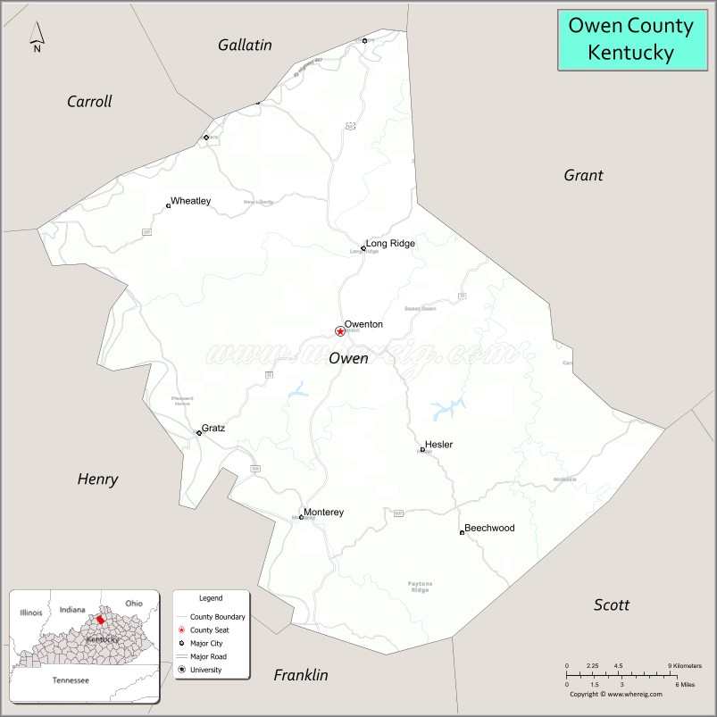
About Owen County Map, Kentucky: The map showing the county boundary, county seat, major cities, highways, water bodies and neighbouring counties.
More Kentucky Maps & Info
Map of Owen County, Kentucky
Owen County is a county located in the U.S. state of Kentucky. It's county seat is Owenton. As per 2020 census, the population of Owen County is 11294 people and population density is square miles. According to the United States Census Bureau, the county has a total area of 352 sq mi (912 km2). Owen County was established on 1819.
Owen County Facts
| Continent | North America |
| Country | United States |
| State | Kentucky |
| County Seat | Owenton |
| Largest City/Town | Owenton |
| Established | 1819 |
| Total Area | 354 sq mi (917 sq km) |
| Land Area | 351 sq mi (909 sq km) |
| Water Area | 2.8 sq mi (7 sq km) |
| Population | 11,278 (Census 2020) |
| Population Density | 32 people per sq mi |
| Time Zone | Eastern Time Zone (ET) |
| Major Highways | Interstate 71 nearby area, U.S. Route 127, Kentucky Route 22, Kentucky Route 355 |
| Major Rivers | Kentucky River, Eagle Creek |
| Neighboring Counties | Grant County, Scott County, Franklin County, Henry County, Gallatin County, Carroll County |
| Famous For | Rolling Bluegrass farmland, Kentucky River scenery, Elk Creek Vineyards, and rural Kentucky heritage |
| Top Attractions | Elk Creek Vineyards, Owen County Courthouse Square, Kentucky River scenic areas, Elmer Davis Lake, General William O. Butler House |
| Official Website | Official Website |
About Owen County, Kentucky
Owen County is located in north-central Kentucky between Cincinnati and Louisville and was established in 1819. The county seat and largest city is Owenton. Owen County is known for scenic Bluegrass countryside, vineyards, Kentucky River landscapes, historic small towns, and peaceful rural communities that reflect traditional Kentucky culture. ([en.wikipedia.org](https://en.wikipedia.org/wiki/Owen_County%2C_Kentucky?utm_source=chatgpt.com))
Cities and Communities in Owen County, Kentucky
| City/Town | Population | Latitude & Longitude |
|---|---|---|
| Owenton (county seat) | 1,700+ | 38.5367°N, 84.8419°W |
| Gratz | 100+ | 38.4476°N, 84.9494°W |
| Monterey | Small Community | 38.5308°N, 84.8858°W |
| Hesler | Rural Community | 38.4702°N, 84.7617°W |
| New Liberty | Historic Community | 38.6204°N, 84.7806°W |
| Perry Park Nearby Area | Regional Area | 38.5085°N, 84.8132°W |
| Big Twin | Unincorporated | 38.5807°N, 84.9285°W |
| Masons Landing | River Community | 38.4751°N, 84.9702°W |
Best Golf Courses in Owen County, Kentucky
| Golf Course | Location | Latitude & Longitude |
|---|---|---|
| Perry Park Golf Resort | Perry Park Area | 38.5059°N, 84.8124°W |
| Cherry Blossom Golf Club | Nearby Georgetown | 38.2248°N, 84.5584°W |
| Houston Oaks Golf Course | Nearby Paris | 38.2096°N, 84.2413°W |
| Nevel Meade Golf Course | Nearby Prospect | 38.3845°N, 85.5917°W |
What are Major Roads and Highways in Owen County
Major highways connect Owen County with northern Kentucky, Louisville, Lexington, and nearby Bluegrass communities.
- Interstate 71 nearby area - major interstate linking Louisville and Cincinnati
- U.S. Route 127 - important north-south highway through Owenton and surrounding farmland
- Kentucky Route 22 - scenic roadway connecting rural communities and regional towns
- Kentucky Route 355 - regional connector route serving agricultural areas
Neighboring Counties of Owen County
- Grant County (north)
- Scott County (east)
- Franklin County (south)
- Henry County (southwest)
- Gallatin County (northwest)
- Carroll County (west)
What are Top Attractions in Owen County, Kentucky
The county offers vineyards, river scenery, historic landmarks, outdoor recreation, and scenic Bluegrass countryside attractions.
| Main Sight Name | City | Famous For |
|---|---|---|
| Elk Creek Vineyards | Owenton Area | Winery tours, tastings, and vineyard scenery |
| Owen County Courthouse Square | Owenton | Historic downtown architecture and local shops |
| Kentucky River Scenic Areas | Countywide | River overlooks, boating, and photography |
| Elmer Davis Lake | Owenton Area | Fishing, boating, and outdoor recreation |
| General William O. Butler House | Carrollton Nearby Area | Historic Kentucky heritage landmark |
| Perry Park Resort Area | Perry Park | Golf, hiking, and nature recreation |
| Historic Rural Churches | Countywide | Architectural heritage and local traditions |
| Scenic Bluegrass Drives | Countywide | Rolling farmland and horse-country scenery |
| Community Heritage Festivals | Owenton Area | Seasonal celebrations and local traditions |
| Outdoor Nature Trails | Countywide | Wildlife viewing and countryside recreation |
Distance from Owen County to Nearby Cities
The following distances are measured by road (driving).
- Owenton to Frankfort, Kentucky - 29 mi (47 km)
- Owenton to Lexington, Kentucky - 47 mi (76 km)
- Owenton to Cincinnati, Ohio - 49 mi (79 km)
- Owenton to Louisville, Kentucky - 67 mi (108 km)
- Owenton to Indianapolis, Indiana - 111 mi (179 km)
- Owenton to Columbus, Ohio - 157 mi (253 km)
- Owenton to Bowling Green, Kentucky - 146 mi (235 km)
- Owenton to Nashville, Tennessee - 226 mi (364 km)
- Owenton to Knoxville, Tennessee - 255 mi (410 km)
- Owenton to Chicago, Illinois - 304 mi (489 km)
- Owenton to St. Louis, Missouri - 311 mi (500 km)
- Owenton to Atlanta, Georgia - 390 mi (628 km)
References
- Owen County Official Website
- Owen County, Kentucky - Wikipedia
- U.S. Census Bureau QuickFacts
- Elk Creek Vineyards
- Kentucky Tourism
- Adair County Map
- Allen County Map
- Anderson County Map
- Ballard County Map
- Barren County Map
- Bath County Map
- Bell County Map
- Boone County Map
- Bourbon County Map
- Boyd County Map
- Boyle County Map
- Bracken County Map
- Breathitt County Map
- Breckinridge County Map
- Bullitt County Map
- Butler County Map
- Caldwell County Map
- Calloway County Map
- Campbell County Map
- Carlisle County Map
- Carroll County Map
- Carter County Map
- Casey County Map
- Christian County Map
- Clark County Map
- Clay County Map
- Clinton County Map
- Crittenden County Map
- Cumberland County Map
- Daviess County Map
- Edmonson County Map
- Elliott County Map
- Estill County Map
- Fayette County Map
- Fleming County Map
- Floyd County Map
- Franklin County Map
- Fulton County Map
- Gallatin County Map
- Garrard County Map
- Grant County Map
- Graves County Map
- Grayson County Map
- Green County Map
- Greenup County Map
- Hancock County Map
- Hardin County Map
- Harlan County Map
- Harrison County Map
- Hart County Map
- Henderson County Map
- Henry County Map
- Hickman County Map
- Hopkins County Map
- Jackson County Map
- Jefferson County Map
- Jessamine County Map
- Johnson County Map
- Kenton County Map
- Knott County Map
- Knox County Map
- LaRue County Map
- Laurel County Map
- Lawrence County Map
- Lee County Map
- Leslie County Map
- Letcher County Map
- Lewis County Map
- Lincoln County Map
- Livingston County Map
- Logan County Map
- Lyon County Map
- McCracken County Map
- McCreary County Map
- McLean County Map
- Madison County Map
- Magoffin County Map
- Marion County Map
- Marshall County Map
- Martin County Map
- Mason County Map
- Meade County Map
- Menifee County Map
- Mercer County Map
- Metcalfe County Map
- Monroe County Map
- Montgomery County Map
- Morgan County Map
- Muhlenberg County Map
- Nelson County Map
- Nicholas County Map
- Ohio County Map
- Oldham County Map
- Owen County Map
- Owsley County Map
- Pendleton County Map
- Perry County Map
- Pike County Map
- Powell County Map
- Pulaski County Map
- Robertson County Map
- Rockcastle County Map
- Rowan County Map
- Russell County Map
- Scott County Map
- Shelby County Map
- Simpson County Map
- Spencer County Map
- Taylor County Map
- Todd County Map
- Trigg County Map
- Trimble County Map
- Union County Map
- Warren County Map
- Washington County Map
- Wayne County Map
- Webster County Map
- Whitley County Map
- Wolfe County Map
- Woodford County Map
- Alabama Counties
- Alaska boroughs
- Arizona Counties
- Arkansas Counties
- California County Map
- Colorado Counties
- Connecticut Counties
- Delaware Counties
- Florida County Map
- Georgia County Map
- Hawaii Counties
- Idaho Counties
- Illinois Counties
- Indiana Counties
- Iowa Counties
- Kansas Counties
- Kentucky Counties
- Louisiana Counties
- Maine Counties
- Maryland Counties
- Massachusetts Counties
- Michigan County Map
- Minnesota Counties
- Mississippi Counties
- Missouri Counties
- Montana Counties
- Nebraska Counties
- Nevada Counties
- New York Counties
- New Hampshire Counties
- New Jersey Counties
- New Mexico Counties
- North Carolina Counties
- North Dakota Counties
- Ohio County Map
- Oklahoma Counties
- Oregon Counties
- Pennsylvania Counties
- Rhode Island Counties
- South Carolina Counties
- South Dakota Counties
- Map of Tennessee
- Texas County Map
- Utah Counties
- Vermont Counties
- Virginia Counties
- Washington Counties
- West Virginia Counties
- Wisconsin Counties
- Wyoming Counties