Map of Franklin County - Franklin County is a county located in the U.S. state of Kentucky. Franklin County Map showing cities, highways, important places and water bodies. Get Where is Franklin County located in the map, major cities in Franklin county, population, areas, and places of interest.
Map of Franklin County, Kentucky
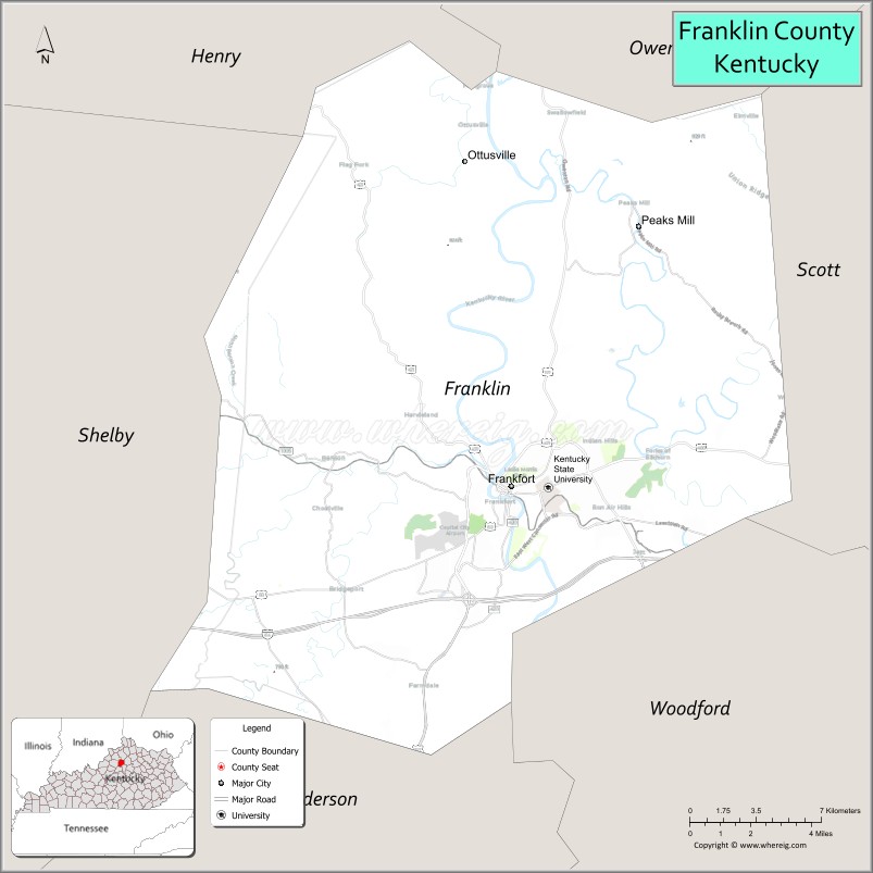
About Franklin County Map, Kentucky: The map showing the county boundary, county seat, major cities, highways, water bodies and neighbouring counties.
More Kentucky Maps & Info
Map of Franklin County, Kentucky
Franklin County is a county located in the U.S. state of Kentucky. It's county seat is Frankfort. As per 2020 census, the population of Franklin County is 51682 people and population density is square miles. According to the United States Census Bureau, the county has a total area of 210 sq mi (544 km2). Franklin County was established on 1794.
Franklin County Facts
| Continent | North America |
| Country | United States |
| State | Kentucky |
| County Seat | Frankfort |
| Largest City/Town | Frankfort |
| Established | 1795 |
| Total Area | 212 sq mi (549 sq km) |
| Land Area | 208 sq mi (539 sq km) |
| Water Area | 3.7 sq mi (10 sq km) |
| Population | 51,682 (Census 2020) |
| Population Density | 248 people per sq mi |
| Time Zone | Eastern Time Zone (ET) |
| Major Highways | Interstate 64, U.S. Route 60, U.S. Route 127, Kentucky Route 421 |
| Major Rivers | Kentucky River, Elkhorn Creek |
| Neighboring Counties | Woodford County, Scott County, Shelby County, Anderson County, Owen County |
| Famous For | Kentucky state capital, bourbon distilleries, historic government buildings, and Bluegrass scenery |
| Top Attractions | Kentucky State Capitol, Buffalo Trace Distillery, Kentucky History Center, Daniel Boone Burial Site, Salato Wildlife Education Center |
| Official Website | Official Website |
About Franklin County, Kentucky
Franklin County is located in central Kentucky within the Bluegrass region and was established in 1795. The county seat and largest city is Frankfort, the capital city of Kentucky. Franklin County is known for state government institutions, bourbon production, historic architecture, horse farms, and scenic Kentucky River landscapes. ([en.wikipedia.org](https://en.wikipedia.org/wiki/Franklin_County%2C_Kentucky?utm_source=chatgpt.com))
Cities and Communities in Franklin County, Kentucky
| City/Town | Population | Latitude & Longitude |
|---|---|---|
| Frankfort (county seat) | 28,000+ | 38.2009°N, 84.8733°W |
| Bald Knob | Unincorporated | 38.2557°N, 84.8625°W |
| Bridgeport | Historic Community | 38.2469°N, 84.9010°W |
| Jett | Unincorporated | 38.1696°N, 84.7938°W |
| Switzer | Unincorporated | 38.3034°N, 84.8805°W |
| Forks of Elkhorn | Historic Community | 38.2678°N, 84.8202°W |
| Peaksmill | Historic Community | 38.3228°N, 84.8474°W |
| Bellepoint | Neighborhood Area | 38.2054°N, 84.8716°W |
Best Golf Courses in Franklin County, Kentucky
| Golf Course | Location | Latitude & Longitude |
|---|---|---|
| Juniper Hill Golf Course | Frankfort | 38.1881°N, 84.8729°W |
| Frankfort Country Club | Frankfort | 38.1760°N, 84.8496°W |
| The Golf Club at Griffin Gate | Nearby Lexington | 38.0970°N, 84.4818°W |
| Cherry Blossom Golf Club | Nearby Georgetown | 38.2129°N, 84.5547°W |
What are Major Roads and Highways in Franklin County
Major highways connect Franklin County with Lexington, Louisville, and central Kentucky communities.
- Interstate 64 - major east-west interstate connecting Frankfort with Louisville and Lexington
- U.S. Route 60 - important regional highway through Frankfort and the Bluegrass region
- U.S. Route 127 - north-south route connecting Frankfort with Lawrenceburg and northern Kentucky
- Kentucky Route 421 - scenic roadway serving rural and river communities
Neighboring Counties of Franklin County
- Woodford County (east)
- Scott County (northeast)
- Shelby County (west)
- Anderson County (south)
- Owen County (north)
What are Top Attractions in Franklin County, Kentucky
The county offers historic landmarks, bourbon tourism, museums, government buildings, and scenic outdoor attractions.
| Main Sight Name | City | Famous For |
|---|---|---|
| Kentucky State Capitol | Frankfort | Historic state government building and architecture |
| Buffalo Trace Distillery | Frankfort | Historic bourbon production and distillery tours |
| Kentucky History Center | Frankfort | State history exhibits and cultural collections |
| Daniel Boone Burial Site | Frankfort | Historic pioneer memorial |
| Salato Wildlife Education Center | Frankfort | Wildlife exhibits and nature trails |
| Old State Capitol | Frankfort | Historic government landmark and museum |
| Kentucky River Scenic Area | Countywide | River views, kayaking, and outdoor recreation |
| Rebecca Ruth Candy Tours | Frankfort | Historic candy factory and regional treats |
| Downtown Frankfort | Frankfort | Restaurants, boutiques, and historic districts |
| Bluegrass Horse Farms | Countywide | Scenic farmland and horse breeding landscapes |
Distance from Franklin County to Nearby Cities
The following distances are measured by road (driving).
- Frankfort to Lexington, Kentucky - 29 mi (47 km)
- Frankfort to Louisville, Kentucky - 52 mi (84 km)
- Frankfort to Georgetown, Kentucky - 20 mi (32 km)
- Frankfort to Richmond, Kentucky - 52 mi (84 km)
- Frankfort to Cincinnati, Ohio - 83 mi (134 km)
- Frankfort to Bowling Green, Kentucky - 113 mi (182 km)
- Frankfort to Indianapolis, Indiana - 147 mi (237 km)
- Frankfort to Nashville, Tennessee - 204 mi (328 km)
- Frankfort to Columbus, Ohio - 186 mi (299 km)
- Frankfort to Knoxville, Tennessee - 194 mi (312 km)
- Frankfort to Chicago, Illinois - 320 mi (515 km)
- Frankfort to St. Louis, Missouri - 282 mi (454 km)
References
- Franklin County Official Website
- Franklin County, Kentucky - Wikipedia
- U.S. Census Bureau QuickFacts
- Visit Frankfort Tourism
- Kentucky Atlas and Gazetteer
- Adair County Map
- Allen County Map
- Anderson County Map
- Ballard County Map
- Barren County Map
- Bath County Map
- Bell County Map
- Boone County Map
- Bourbon County Map
- Boyd County Map
- Boyle County Map
- Bracken County Map
- Breathitt County Map
- Breckinridge County Map
- Bullitt County Map
- Butler County Map
- Caldwell County Map
- Calloway County Map
- Campbell County Map
- Carlisle County Map
- Carroll County Map
- Carter County Map
- Casey County Map
- Christian County Map
- Clark County Map
- Clay County Map
- Clinton County Map
- Crittenden County Map
- Cumberland County Map
- Daviess County Map
- Edmonson County Map
- Elliott County Map
- Estill County Map
- Fayette County Map
- Fleming County Map
- Floyd County Map
- Franklin County Map
- Fulton County Map
- Gallatin County Map
- Garrard County Map
- Grant County Map
- Graves County Map
- Grayson County Map
- Green County Map
- Greenup County Map
- Hancock County Map
- Hardin County Map
- Harlan County Map
- Harrison County Map
- Hart County Map
- Henderson County Map
- Henry County Map
- Hickman County Map
- Hopkins County Map
- Jackson County Map
- Jefferson County Map
- Jessamine County Map
- Johnson County Map
- Kenton County Map
- Knott County Map
- Knox County Map
- LaRue County Map
- Laurel County Map
- Lawrence County Map
- Lee County Map
- Leslie County Map
- Letcher County Map
- Lewis County Map
- Lincoln County Map
- Livingston County Map
- Logan County Map
- Lyon County Map
- McCracken County Map
- McCreary County Map
- McLean County Map
- Madison County Map
- Magoffin County Map
- Marion County Map
- Marshall County Map
- Martin County Map
- Mason County Map
- Meade County Map
- Menifee County Map
- Mercer County Map
- Metcalfe County Map
- Monroe County Map
- Montgomery County Map
- Morgan County Map
- Muhlenberg County Map
- Nelson County Map
- Nicholas County Map
- Ohio County Map
- Oldham County Map
- Owen County Map
- Owsley County Map
- Pendleton County Map
- Perry County Map
- Pike County Map
- Powell County Map
- Pulaski County Map
- Robertson County Map
- Rockcastle County Map
- Rowan County Map
- Russell County Map
- Scott County Map
- Shelby County Map
- Simpson County Map
- Spencer County Map
- Taylor County Map
- Todd County Map
- Trigg County Map
- Trimble County Map
- Union County Map
- Warren County Map
- Washington County Map
- Wayne County Map
- Webster County Map
- Whitley County Map
- Wolfe County Map
- Woodford County Map
- Alabama Counties
- Alaska boroughs
- Arizona Counties
- Arkansas Counties
- California County Map
- Colorado Counties
- Connecticut Counties
- Delaware Counties
- Florida County Map
- Georgia County Map
- Hawaii Counties
- Idaho Counties
- Illinois Counties
- Indiana Counties
- Iowa Counties
- Kansas Counties
- Kentucky Counties
- Louisiana Counties
- Maine Counties
- Maryland Counties
- Massachusetts Counties
- Michigan County Map
- Minnesota Counties
- Mississippi Counties
- Missouri Counties
- Montana Counties
- Nebraska Counties
- Nevada Counties
- New York Counties
- New Hampshire Counties
- New Jersey Counties
- New Mexico Counties
- North Carolina Counties
- North Dakota Counties
- Ohio County Map
- Oklahoma Counties
- Oregon Counties
- Pennsylvania Counties
- Rhode Island Counties
- South Carolina Counties
- South Dakota Counties
- Map of Tennessee
- Texas County Map
- Utah Counties
- Vermont Counties
- Virginia Counties
- Washington Counties
- West Virginia Counties
- Wisconsin Counties
- Wyoming Counties