Map of Nelson County - Nelson County is a county located in the U.S. state of Kentucky. Nelson County Map showing cities, highways, important places and water bodies. Get Where is Nelson County located in the map, major cities in Nelson county, population, areas, and places of interest.
Map of Nelson County, Kentucky
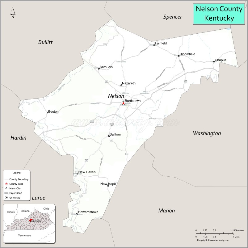
About Nelson County Map, Kentucky: The map showing the county boundary, county seat, major cities, highways, water bodies and neighbouring counties.
More Kentucky Maps & Info
Map of Nelson County, Kentucky
Nelson County is a county located in the U.S. state of Kentucky. It's county seat is Bardstown. As per 2020 census, the population of Nelson County is 47098 people and population density is square miles. According to the United States Census Bureau, the county has a total area of 423 sq mi (1,096 km2). Nelson County was established on 1784.
Nelson County Facts
| Continent | North America |
| Country | United States |
| State | Kentucky |
| County Seat | Bardstown |
| Largest City/Town | Bardstown |
| Established | 1784 |
| Total Area | 424 sq mi (1,098 sq km) |
| Land Area | 418 sq mi (1,083 sq km) |
| Water Area | 6.6 sq mi (17 sq km) |
| Population | 46,738 (Census 2020) |
| Population Density | 112 people per sq mi |
| Time Zone | Eastern Time Zone (ET) |
| Major Highways | Bluegrass Parkway, U.S. Route 31E, U.S. Route 150, Kentucky Route 245 |
| Major Rivers | Rolling Fork River, Beech Fork River |
| Neighboring Counties | Spencer County, Anderson County, Washington County, Marion County, LaRue County, Hardin County, Bullitt County |
| Famous For | Bourbon Capital of the World, Bardstown historic district, bourbon distilleries, and Kentucky heritage tourism |
| Top Attractions | My Old Kentucky Home State Park, Heaven Hill Bourbon Experience, Willett Distillery, Bardstown Historic District, Bernheim Forest nearby area |
| Official Website | Official Website |
About Nelson County, Kentucky
Nelson County is located in north-central Kentucky within the Bluegrass region and was established in 1784 as one of Kentucky’s earliest counties. The county seat and largest city is Bardstown, Kentucky’s second-oldest city. Nelson County is internationally known as the “Bourbon Capital of the World” because of its concentration of bourbon distilleries, historic downtown districts, scenic rolling farmland, and strong ties to Kentucky heritage tourism. :contentReference[oaicite:0]{index=0}
Cities and Communities in Nelson County, Kentucky
| City/Town | Population | Latitude & Longitude |
|---|---|---|
| Bardstown (county seat) | 14,000+ | 37.8092°N, 85.4669°W |
| Bloomfield | 1,000+ | 37.9134°N, 85.3169°W |
| New Haven | 800+ | 37.6573°N, 85.5919°W |
| Fairfield | 100+ | 37.9340°N, 85.3933°W |
| Boston | Historic Community | 37.7587°N, 85.6747°W |
| Coxs Creek | Growing Community | 37.8792°N, 85.4341°W |
| Holy Cross | Historic Community | 37.6223°N, 85.4483°W |
| Nazareth | Historic Religious Community | 37.8947°N, 85.3956°W |
Best Golf Courses in Nelson County, Kentucky
| Golf Course | Location | Latitude & Longitude |
|---|---|---|
| Bardstown Country Club at Maywood | Bardstown | 37.8412°N, 85.4787°W |
| My Old Kentucky Home Golf Course | Bardstown | 37.7998°N, 85.4548°W |
| Lincoln Homestead State Park Golf Course | Nearby Springfield | 37.7025°N, 85.2484°W |
| Heritage Hill Golf Club | Nearby Shepherdsville | 37.9378°N, 85.6654°W |
What are Major Roads and Highways in Nelson County
Major highways connect Nelson County with Louisville, central Kentucky bourbon regions, and Bluegrass tourism destinations.
- Bluegrass Parkway - major east-west parkway linking Bardstown with Lexington and Elizabethtown
- U.S. Route 31E - important north-south highway through Bardstown and surrounding communities
- U.S. Route 150 - scenic regional highway connecting Bluegrass towns and tourism areas
- Kentucky Route 245 - major route serving bourbon distilleries and local communities
Neighboring Counties of Nelson County
- Spencer County (north)
- Anderson County (northeast)
- Washington County (east)
- Marion County (southeast)
- LaRue County (south)
- Hardin County (west)
- Bullitt County (northwest)
What are Top Attractions in Nelson County, Kentucky
The county offers bourbon tourism, historic architecture, state parks, scenic countryside, and nationally recognized Kentucky heritage attractions. :contentReference[oaicite:1]{index=1}
| Main Sight Name | City | Famous For |
|---|---|---|
| My Old Kentucky Home State Park | Bardstown | Historic mansion and Kentucky cultural heritage |
| Heaven Hill Bourbon Experience | Bardstown | Bourbon tastings and whiskey history |
| Willett Distillery | Bardstown | Historic bourbon production and tours |
| Bardstown Historic District | Bardstown | Historic downtown architecture and shops |
| Bernheim Forest Nearby Area | Regional Area | Nature trails, giant forest sculptures, and hiking |
| Old Talbott Tavern | Bardstown | Historic inn and frontier-era landmark |
| Bourbon Heritage Center | Bardstown | Kentucky bourbon education and exhibits |
| Railroad Museum | New Haven | Historic rail exhibits and train heritage |
| Bardstown Bourbon Company | Bardstown | Modern distillery tours and tastings |
| Historic Churches of Nelson County | Countywide | Religious heritage and historic architecture |
Distance from Nelson County to Nearby Cities
The following distances are measured by road (driving).
- Bardstown to Louisville, Kentucky - 39 mi (63 km)
- Bardstown to Elizabethtown, Kentucky - 29 mi (47 km)
- Bardstown to Lexington, Kentucky - 66 mi (106 km)
- Bardstown to Bowling Green, Kentucky - 88 mi (142 km)
- Bardstown to Cincinnati, Ohio - 123 mi (198 km)
- Bardstown to Indianapolis, Indiana - 151 mi (243 km)
- Bardstown to Nashville, Tennessee - 172 mi (277 km)
- Bardstown to Knoxville, Tennessee - 217 mi (349 km)
- Bardstown to St. Louis, Missouri - 275 mi (443 km)
- Bardstown to Chicago, Illinois - 312 mi (502 km)
- Bardstown to Atlanta, Georgia - 357 mi (575 km)
- Bardstown to Columbus, Ohio - 205 mi (330 km)
References
- Nelson County Official Website
- Nelson County, Kentucky - Wikipedia
- U.S. Census Bureau QuickFacts
- Visit Bardstown Tourism
- My Old Kentucky Home State Park
- Adair County Map
- Allen County Map
- Anderson County Map
- Ballard County Map
- Barren County Map
- Bath County Map
- Bell County Map
- Boone County Map
- Bourbon County Map
- Boyd County Map
- Boyle County Map
- Bracken County Map
- Breathitt County Map
- Breckinridge County Map
- Bullitt County Map
- Butler County Map
- Caldwell County Map
- Calloway County Map
- Campbell County Map
- Carlisle County Map
- Carroll County Map
- Carter County Map
- Casey County Map
- Christian County Map
- Clark County Map
- Clay County Map
- Clinton County Map
- Crittenden County Map
- Cumberland County Map
- Daviess County Map
- Edmonson County Map
- Elliott County Map
- Estill County Map
- Fayette County Map
- Fleming County Map
- Floyd County Map
- Franklin County Map
- Fulton County Map
- Gallatin County Map
- Garrard County Map
- Grant County Map
- Graves County Map
- Grayson County Map
- Green County Map
- Greenup County Map
- Hancock County Map
- Hardin County Map
- Harlan County Map
- Harrison County Map
- Hart County Map
- Henderson County Map
- Henry County Map
- Hickman County Map
- Hopkins County Map
- Jackson County Map
- Jefferson County Map
- Jessamine County Map
- Johnson County Map
- Kenton County Map
- Knott County Map
- Knox County Map
- LaRue County Map
- Laurel County Map
- Lawrence County Map
- Lee County Map
- Leslie County Map
- Letcher County Map
- Lewis County Map
- Lincoln County Map
- Livingston County Map
- Logan County Map
- Lyon County Map
- McCracken County Map
- McCreary County Map
- McLean County Map
- Madison County Map
- Magoffin County Map
- Marion County Map
- Marshall County Map
- Martin County Map
- Mason County Map
- Meade County Map
- Menifee County Map
- Mercer County Map
- Metcalfe County Map
- Monroe County Map
- Montgomery County Map
- Morgan County Map
- Muhlenberg County Map
- Nelson County Map
- Nicholas County Map
- Ohio County Map
- Oldham County Map
- Owen County Map
- Owsley County Map
- Pendleton County Map
- Perry County Map
- Pike County Map
- Powell County Map
- Pulaski County Map
- Robertson County Map
- Rockcastle County Map
- Rowan County Map
- Russell County Map
- Scott County Map
- Shelby County Map
- Simpson County Map
- Spencer County Map
- Taylor County Map
- Todd County Map
- Trigg County Map
- Trimble County Map
- Union County Map
- Warren County Map
- Washington County Map
- Wayne County Map
- Webster County Map
- Whitley County Map
- Wolfe County Map
- Woodford County Map
- Alabama Counties
- Alaska boroughs
- Arizona Counties
- Arkansas Counties
- California County Map
- Colorado Counties
- Connecticut Counties
- Delaware Counties
- Florida County Map
- Georgia County Map
- Hawaii Counties
- Idaho Counties
- Illinois Counties
- Indiana Counties
- Iowa Counties
- Kansas Counties
- Kentucky Counties
- Louisiana Counties
- Maine Counties
- Maryland Counties
- Massachusetts Counties
- Michigan County Map
- Minnesota Counties
- Mississippi Counties
- Missouri Counties
- Montana Counties
- Nebraska Counties
- Nevada Counties
- New York Counties
- New Hampshire Counties
- New Jersey Counties
- New Mexico Counties
- North Carolina Counties
- North Dakota Counties
- Ohio County Map
- Oklahoma Counties
- Oregon Counties
- Pennsylvania Counties
- Rhode Island Counties
- South Carolina Counties
- South Dakota Counties
- Map of Tennessee
- Texas County Map
- Utah Counties
- Vermont Counties
- Virginia Counties
- Washington Counties
- West Virginia Counties
- Wisconsin Counties
- Wyoming Counties