Map of Washington County - Washington County is a county located in the U.S. state of Kentucky. Washington County Map showing cities, highways, important places and water bodies. Get Where is Washington County located in the map, major cities in Washington county, population, areas, and places of interest.
Map of Washington County, Kentucky
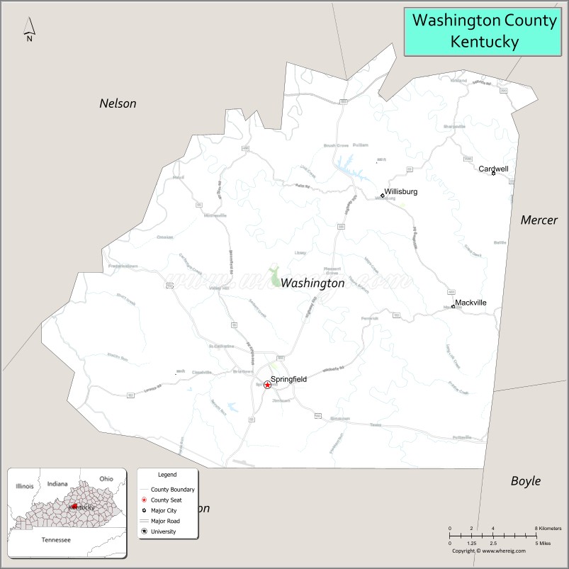
About Washington County Map, Kentucky: The map showing the county boundary, county seat, major cities, highways, water bodies and neighbouring counties.
More Kentucky Maps & Info
Map of Washington County, Kentucky
Washington County is a county located in the U.S. state of Kentucky. It's county seat is Springfield. As per 2020 census, the population of Washington County is 12072 people and population density is square miles. According to the United States Census Bureau, the county has a total area of 301 sq mi (780 km2). Washington County was established on 1792.
Washington County Facts
| Continent | North America |
| Country | United States |
| State | Kentucky |
| County Seat | Springfield |
| Largest City/Town | Springfield |
| Established | 1792 |
| Total Area | 301 sq mi (780 sq km) |
| Land Area | 297 sq mi (769 sq km) |
| Water Area | 3.9 sq mi (10 sq km) |
| Population | 12,027 (Census 2020) |
| Population Density | 41 people per sq mi |
| Time Zone | Eastern Time Zone (ET) |
| Major Highways | U.S. Route 150, U.S. Route 68, Kentucky Route 55, Kentucky Route 555 |
| Major Rivers | Beech Fork River, Chaplin River tributaries |
| Neighboring Counties | Anderson County, Mercer County, Boyle County, Marion County, Nelson County |
| Famous For | Kentucky’s first county, bourbon heritage, historic Springfield, and Lincoln family history |
| Top Attractions | Lincoln Homestead State Park, Historic Springfield, Maker’s Mark Distillery nearby area, St. Rose Priory, Washington County Courthouse |
| Official Website | Official Website |
About Washington County, Kentucky
Washington County is located in central Kentucky within the Bluegrass region and was established in 1792 as the first county created by the Commonwealth of Kentucky. The county seat and largest city is Springfield. Washington County is known for its historic significance, bourbon heritage, Lincoln family connections, rolling farmland, and early Kentucky settlement history along the Wilderness Trace. :contentReference[oaicite:0]{index=0}
Cities and Communities in Washington County, Kentucky
| City/Town | Population | Latitude & Longitude |
|---|---|---|
| Springfield (county seat) | 2,800+ | 37.6853°N, 85.2222°W |
| Willisburg | 300+ | 37.8101°N, 85.1252°W |
| Mackville | 200+ | 37.7490°N, 85.0700°W |
| Fredericktown | Historic Community | 37.7476°N, 85.3741°W |
| Saint Catharine | Historic Religious Community | 37.6948°N, 85.2575°W |
| Manton | Rural Community | 37.4884°N, 85.1132°W |
| Mooresville | Agricultural Area | 37.7267°N, 85.1598°W |
| Pleasant Grove | Unincorporated | 37.6061°N, 85.3065°W |
Best Golf Courses in Washington County, Kentucky
| Golf Course | Location | Latitude & Longitude |
|---|---|---|
| Lincoln Homestead State Park Golf Course | Springfield Area | 37.5688°N, 85.1441°W |
| Rosewood Golf & Country Club | Nearby Lebanon | 37.5717°N, 85.2386°W |
| Bright Leaf Golf Resort | Nearby Harrodsburg | 37.7425°N, 84.8172°W |
| My Old Kentucky Home Golf Course | Nearby Bardstown | 37.7993°N, 85.4588°W |
What are Major Roads and Highways in Washington County
Major highways connect Washington County with Bardstown, Lexington, Louisville, and central Kentucky historic regions. :contentReference[oaicite:1]{index=1}
- U.S. Route 150 - historic highway through Springfield and central Kentucky
- U.S. Route 68 - important east-west route connecting Bluegrass communities
- Kentucky Route 55 - major north-south roadway through rural and urban areas
- Kentucky Route 555 - scenic connector route through farmland and rolling hills
Neighboring Counties of Washington County
- Anderson County (north)
- Mercer County (east)
- Boyle County (east)
- Marion County (south)
- Nelson County (west)
What are Top Attractions in Washington County, Kentucky
The county offers historic sites, bourbon attractions, scenic countryside, religious landmarks, and early Kentucky heritage destinations. :contentReference[oaicite:2]{index=2}
| Main Sight Name | City | Famous For |
|---|---|---|
| Lincoln Homestead State Park | Springfield Area | Lincoln family history and pioneer heritage |
| Historic Springfield | Springfield | Historic courthouse square and early Kentucky architecture |
| Maker’s Mark Distillery Nearby Area | Loretto Area | Bourbon tours and Kentucky whiskey heritage |
| St. Rose Priory | Springfield Area | Historic Catholic religious heritage |
| Washington County Courthouse | Springfield | Oldest courthouse still in use in Kentucky |
| Mordecai Lincoln House | Springfield | Lincoln family historic site |
| Beech Fork Scenic Areas | Countywide | Nature scenery and countryside photography |
| Historic Wilderness Trace Routes | Countywide | Early pioneer travel history |
| Central Kentucky Scenic Drives | Countywide | Rolling farmland and Bluegrass landscapes |
| Community Festivals and Events | Springfield Area | Local traditions and seasonal celebrations |
Distance from Washington County to Nearby Cities
The following distances are measured by road (driving).
- Springfield to Bardstown, Kentucky - 21 mi (34 km)
- Springfield to Lebanon, Kentucky - 18 mi (29 km)
- Springfield to Frankfort, Kentucky - 49 mi (79 km)
- Springfield to Louisville, Kentucky - 61 mi (98 km)
- Springfield to Lexington, Kentucky - 63 mi (101 km)
- Springfield to Bowling Green, Kentucky - 92 mi (148 km)
- Springfield to Cincinnati, Ohio - 125 mi (201 km)
- Springfield to Nashville, Tennessee - 171 mi (275 km)
- Springfield to Indianapolis, Indiana - 180 mi (290 km)
- Springfield to Knoxville, Tennessee - 210 mi (338 km)
- Springfield to Columbus, Ohio - 243 mi (391 km)
- Springfield to Chicago, Illinois - 332 mi (534 km)
References
- Washington County Official Website
- Washington County, Kentucky - Wikipedia
- City of Springfield History
- U.S. Census Bureau QuickFacts
- Preserve America - Springfield, Kentucky
- Adair County Map
- Allen County Map
- Anderson County Map
- Ballard County Map
- Barren County Map
- Bath County Map
- Bell County Map
- Boone County Map
- Bourbon County Map
- Boyd County Map
- Boyle County Map
- Bracken County Map
- Breathitt County Map
- Breckinridge County Map
- Bullitt County Map
- Butler County Map
- Caldwell County Map
- Calloway County Map
- Campbell County Map
- Carlisle County Map
- Carroll County Map
- Carter County Map
- Casey County Map
- Christian County Map
- Clark County Map
- Clay County Map
- Clinton County Map
- Crittenden County Map
- Cumberland County Map
- Daviess County Map
- Edmonson County Map
- Elliott County Map
- Estill County Map
- Fayette County Map
- Fleming County Map
- Floyd County Map
- Franklin County Map
- Fulton County Map
- Gallatin County Map
- Garrard County Map
- Grant County Map
- Graves County Map
- Grayson County Map
- Green County Map
- Greenup County Map
- Hancock County Map
- Hardin County Map
- Harlan County Map
- Harrison County Map
- Hart County Map
- Henderson County Map
- Henry County Map
- Hickman County Map
- Hopkins County Map
- Jackson County Map
- Jefferson County Map
- Jessamine County Map
- Johnson County Map
- Kenton County Map
- Knott County Map
- Knox County Map
- LaRue County Map
- Laurel County Map
- Lawrence County Map
- Lee County Map
- Leslie County Map
- Letcher County Map
- Lewis County Map
- Lincoln County Map
- Livingston County Map
- Logan County Map
- Lyon County Map
- McCracken County Map
- McCreary County Map
- McLean County Map
- Madison County Map
- Magoffin County Map
- Marion County Map
- Marshall County Map
- Martin County Map
- Mason County Map
- Meade County Map
- Menifee County Map
- Mercer County Map
- Metcalfe County Map
- Monroe County Map
- Montgomery County Map
- Morgan County Map
- Muhlenberg County Map
- Nelson County Map
- Nicholas County Map
- Ohio County Map
- Oldham County Map
- Owen County Map
- Owsley County Map
- Pendleton County Map
- Perry County Map
- Pike County Map
- Powell County Map
- Pulaski County Map
- Robertson County Map
- Rockcastle County Map
- Rowan County Map
- Russell County Map
- Scott County Map
- Shelby County Map
- Simpson County Map
- Spencer County Map
- Taylor County Map
- Todd County Map
- Trigg County Map
- Trimble County Map
- Union County Map
- Warren County Map
- Washington County Map
- Wayne County Map
- Webster County Map
- Whitley County Map
- Wolfe County Map
- Woodford County Map
- Alabama Counties
- Alaska boroughs
- Arizona Counties
- Arkansas Counties
- California County Map
- Colorado Counties
- Connecticut Counties
- Delaware Counties
- Florida County Map
- Georgia County Map
- Hawaii Counties
- Idaho Counties
- Illinois Counties
- Indiana Counties
- Iowa Counties
- Kansas Counties
- Kentucky Counties
- Louisiana Counties
- Maine Counties
- Maryland Counties
- Massachusetts Counties
- Michigan County Map
- Minnesota Counties
- Mississippi Counties
- Missouri Counties
- Montana Counties
- Nebraska Counties
- Nevada Counties
- New York Counties
- New Hampshire Counties
- New Jersey Counties
- New Mexico Counties
- North Carolina Counties
- North Dakota Counties
- Ohio County Map
- Oklahoma Counties
- Oregon Counties
- Pennsylvania Counties
- Rhode Island Counties
- South Carolina Counties
- South Dakota Counties
- Map of Tennessee
- Texas County Map
- Utah Counties
- Vermont Counties
- Virginia Counties
- Washington Counties
- West Virginia Counties
- Wisconsin Counties
- Wyoming Counties