Map of Bullitt County - Bullitt County is a county located in the U.S. state of Kentucky. Bullitt County Map showing cities, highways, important places and water bodies. Get Where is Bullitt County located in the map, major cities in Bullitt county, population, areas, and places of interest.
Map of Bullitt County, Kentucky
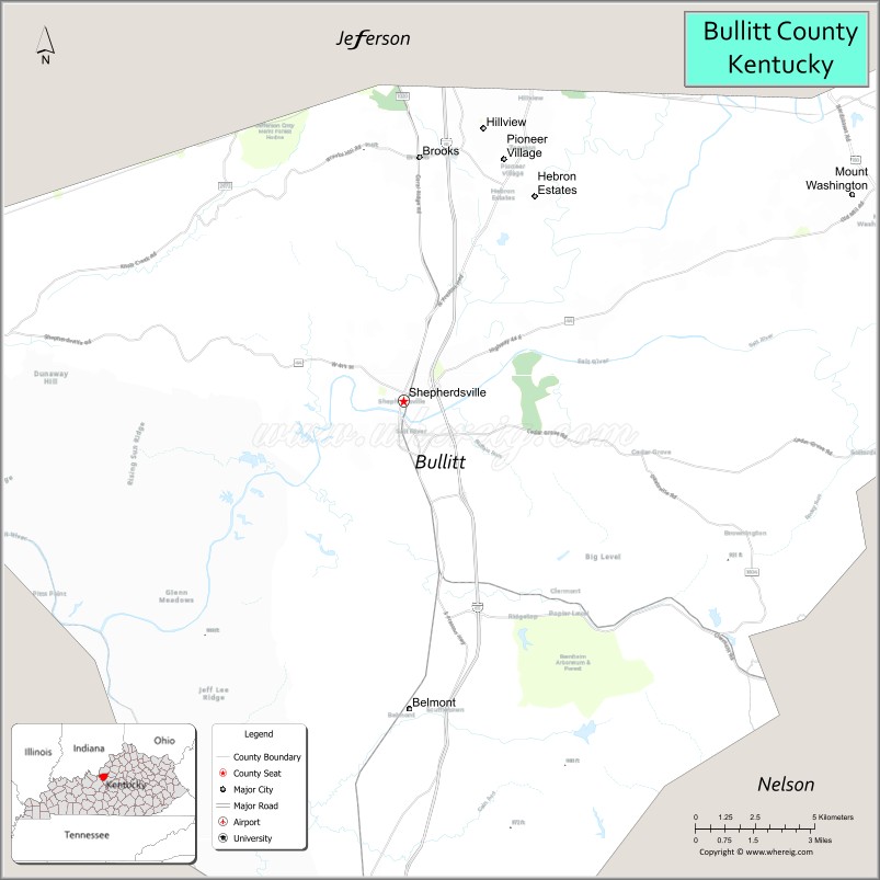
About Bullitt County Map, Kentucky: The map showing the county boundary, county seat, major cities, highways, water bodies and neighbouring counties.
More Kentucky Maps & Info
Map of Bullitt County, Kentucky
Bullitt County is a county located in the U.S. state of Kentucky. It's county seat is Shepherdsville. As per 2020 census, the population of Bullitt County is 82918 people and population density is square miles. According to the United States Census Bureau, the county has a total area of 299 sq mi (774 km2). Bullitt County was established on 1796.
Bullitt County Facts
| Continent | North America |
| Country | United States |
| State | Kentucky |
| County Seat | Shepherdsville |
| Largest City/Town | Mount Washington |
| Established | 1796 |
| Total Area | 300 sq mi (777 sq km) |
| Land Area | 297 sq mi (769 sq km) |
| Water Area | 3 sq mi (8 sq km) |
| Population | 82,217 (Census 2020) |
| Population Density | 277 people per sq mi |
| Time Zone | Eastern Time Zone (ET) |
| Major Highways | Interstate 65, Kentucky Route 44, U.S. Route 31E, Bluegrass Parkway nearby area |
| Major Rivers | Salt River, Rolling Fork River |
| Neighboring Counties | Jefferson County, Nelson County, Spencer County, Hardin County, Meade County |
| Famous For | Bernheim Forest, Louisville suburban growth, logistics centers, and bourbon heritage |
| Top Attractions | Bernheim Arboretum and Research Forest, Jim Beam American Stillhouse, Kart Kountry, Salt River, Forest Edge Winery |
| Official Website | Official Website |
About Bullitt County, Kentucky
Bullitt County is located in north-central Kentucky south of Louisville and was established in 1796. The county seat is Shepherdsville, while Mount Washington is the largest city. Bullitt County is known for its natural forests, growing suburban communities, bourbon tourism, and transportation and distribution industries along Interstate 65. ([en.wikipedia.org](https://en.wikipedia.org/wiki/Bullitt_County%2C_Kentucky?utm_source=chatgpt.com))
Cities and Communities in Bullitt County, Kentucky
| City/Town | Population | Latitude & Longitude |
|---|---|---|
| Shepherdsville (county seat) | 14,000+ | 37.9887°N, 85.7155°W |
| Mount Washington | 18,000+ | 38.0501°N, 85.5458°W |
| Hillview | 8,000+ | 38.0690°N, 85.6844°W |
| Pioneer Village | 2,700+ | 37.9854°N, 85.6841°W |
| Lebanon Junction | 2,000+ | 37.8348°N, 85.7311°W |
| Fox Chase | 500+ | 38.0298°N, 85.7008°W |
| Brooks | Unincorporated | 38.0612°N, 85.7094°W |
| Cedar Grove | Unincorporated | 37.9387°N, 85.6029°W |
Best Golf Courses in Bullitt County, Kentucky
| Golf Course | Location | Latitude & Longitude |
|---|---|---|
| Heritage Hill Golf Club | Shepherdsville | 37.9882°N, 85.7257°W |
| Cherry Valley Golf Course | Shepherdsville | 38.0109°N, 85.6988°W |
| Maplehurst Golf Course | Louisville Nearby Area | 38.1269°N, 85.6872°W |
| Tanglewood Golf Course | Mount Washington Area | 38.0284°N, 85.5582°W |
What are Major Roads and Highways in Bullitt County
Major highways connect Bullitt County with Louisville and central Kentucky communities.
- Interstate 65 - major north-south interstate connecting Louisville with Nashville through Bullitt County
- U.S. Route 31E - regional highway linking Shepherdsville with Louisville and Bardstown
- Kentucky Route 44 - east-west route serving Mount Washington and Shepherdsville
- Bluegrass Parkway nearby area - major route connecting central Kentucky bourbon regions
Neighboring Counties of Bullitt County
- Jefferson County (north)
- Nelson County (south)
- Spencer County (east)
- Hardin County (southwest)
- Meade County (west)
What are Top Attractions in Bullitt County, Kentucky
The county features forests, bourbon attractions, and family recreation destinations.
| Main Sight Name | City | Famous For |
|---|---|---|
| Bernheim Arboretum and Research Forest | Clermont Area | Nature trails, giant forest sculptures, and conservation |
| Jim Beam American Stillhouse | Clermont | Bourbon distillery tours and tastings |
| Kart Kountry | Shepherdsville | Large go-kart track and family entertainment |
| Salt River Scenic Area | Countywide | Fishing, kayaking, and river landscapes |
| Forest Edge Winery | Shepherdsville Area | Local wine tasting and vineyard views |
| Paroquet Springs Conference Centre | Shepherdsville | Community events and conferences |
| Brooks Hill Winery | Brooks Area | Regional winery and countryside scenery |
| Bullitt County History Museum | Shepherdsville | Local heritage exhibits and historical displays |
| Hillview Recreation Area | Hillview | Parks and sports facilities |
| Mount Washington Historic District | Mount Washington | Historic small-town atmosphere and local shops |
Distance from Bullitt County to Nearby Cities
The following distances are measured by road (driving).
- Shepherdsville to Louisville, Kentucky - 20 mi (32 km)
- Shepherdsville to Bardstown, Kentucky - 27 mi (43 km)
- Shepherdsville to Elizabethtown, Kentucky - 33 mi (53 km)
- Shepherdsville to Lexington, Kentucky - 82 mi (132 km)
- Shepherdsville to Bowling Green, Kentucky - 94 mi (151 km)
- Shepherdsville to Frankfort, Kentucky - 63 mi (101 km)
- Shepherdsville to Cincinnati, Ohio - 118 mi (190 km)
- Shepherdsville to Nashville, Tennessee - 155 mi (249 km)
- Shepherdsville to Owensboro, Kentucky - 117 mi (188 km)
- Shepherdsville to Indianapolis, Indiana - 131 mi (211 km)
- Shepherdsville to Knoxville, Tennessee - 244 mi (393 km)
- Shepherdsville to St. Louis, Missouri - 264 mi (425 km)
References
- Bullitt County Official Website
- Bullitt County, Kentucky - Wikipedia
- U.S. Census Bureau QuickFacts
- Bernheim Arboretum and Research Forest
- Jim Beam American Stillhouse
- Adair County Map
- Allen County Map
- Anderson County Map
- Ballard County Map
- Barren County Map
- Bath County Map
- Bell County Map
- Boone County Map
- Bourbon County Map
- Boyd County Map
- Boyle County Map
- Bracken County Map
- Breathitt County Map
- Breckinridge County Map
- Bullitt County Map
- Butler County Map
- Caldwell County Map
- Calloway County Map
- Campbell County Map
- Carlisle County Map
- Carroll County Map
- Carter County Map
- Casey County Map
- Christian County Map
- Clark County Map
- Clay County Map
- Clinton County Map
- Crittenden County Map
- Cumberland County Map
- Daviess County Map
- Edmonson County Map
- Elliott County Map
- Estill County Map
- Fayette County Map
- Fleming County Map
- Floyd County Map
- Franklin County Map
- Fulton County Map
- Gallatin County Map
- Garrard County Map
- Grant County Map
- Graves County Map
- Grayson County Map
- Green County Map
- Greenup County Map
- Hancock County Map
- Hardin County Map
- Harlan County Map
- Harrison County Map
- Hart County Map
- Henderson County Map
- Henry County Map
- Hickman County Map
- Hopkins County Map
- Jackson County Map
- Jefferson County Map
- Jessamine County Map
- Johnson County Map
- Kenton County Map
- Knott County Map
- Knox County Map
- LaRue County Map
- Laurel County Map
- Lawrence County Map
- Lee County Map
- Leslie County Map
- Letcher County Map
- Lewis County Map
- Lincoln County Map
- Livingston County Map
- Logan County Map
- Lyon County Map
- McCracken County Map
- McCreary County Map
- McLean County Map
- Madison County Map
- Magoffin County Map
- Marion County Map
- Marshall County Map
- Martin County Map
- Mason County Map
- Meade County Map
- Menifee County Map
- Mercer County Map
- Metcalfe County Map
- Monroe County Map
- Montgomery County Map
- Morgan County Map
- Muhlenberg County Map
- Nelson County Map
- Nicholas County Map
- Ohio County Map
- Oldham County Map
- Owen County Map
- Owsley County Map
- Pendleton County Map
- Perry County Map
- Pike County Map
- Powell County Map
- Pulaski County Map
- Robertson County Map
- Rockcastle County Map
- Rowan County Map
- Russell County Map
- Scott County Map
- Shelby County Map
- Simpson County Map
- Spencer County Map
- Taylor County Map
- Todd County Map
- Trigg County Map
- Trimble County Map
- Union County Map
- Warren County Map
- Washington County Map
- Wayne County Map
- Webster County Map
- Whitley County Map
- Wolfe County Map
- Woodford County Map
- Alabama Counties
- Alaska boroughs
- Arizona Counties
- Arkansas Counties
- California County Map
- Colorado Counties
- Connecticut Counties
- Delaware Counties
- Florida County Map
- Georgia County Map
- Hawaii Counties
- Idaho Counties
- Illinois Counties
- Indiana Counties
- Iowa Counties
- Kansas Counties
- Kentucky Counties
- Louisiana Counties
- Maine Counties
- Maryland Counties
- Massachusetts Counties
- Michigan County Map
- Minnesota Counties
- Mississippi Counties
- Missouri Counties
- Montana Counties
- Nebraska Counties
- Nevada Counties
- New York Counties
- New Hampshire Counties
- New Jersey Counties
- New Mexico Counties
- North Carolina Counties
- North Dakota Counties
- Ohio County Map
- Oklahoma Counties
- Oregon Counties
- Pennsylvania Counties
- Rhode Island Counties
- South Carolina Counties
- South Dakota Counties
- Map of Tennessee
- Texas County Map
- Utah Counties
- Vermont Counties
- Virginia Counties
- Washington Counties
- West Virginia Counties
- Wisconsin Counties
- Wyoming Counties