Map of Jessamine County - Jessamine County is a county located in the U.S. state of Kentucky. Jessamine County Map showing cities, highways, important places and water bodies. Get Where is Jessamine County located in the map, major cities in Jessamine county, population, areas, and places of interest.
Map of Jessamine County, Kentucky
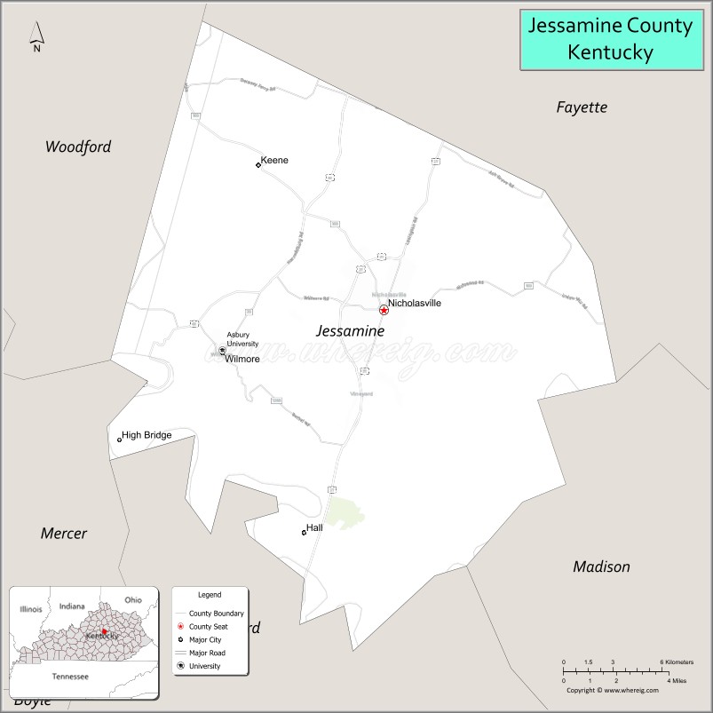
About Jessamine County Map, Kentucky: The map showing the county boundary, county seat, major cities, highways, water bodies and neighbouring counties.
More Kentucky Maps & Info
Map of Jessamine County, Kentucky
Jessamine County is a county located in the U.S. state of Kentucky. It's county seat is Nicholasville. As per 2020 census, the population of Jessamine County is 53626 people and population density is square miles. According to the United States Census Bureau, the county has a total area of 173 sq mi (448 km2). Jessamine County was established on 1798.
Jessamine County Facts
| Continent | North America |
| Country | United States |
| State | Kentucky |
| County Seat | Nicholasville |
| Largest City/Town | Nicholasville |
| Established | 1798 |
| Total Area | 174 sq mi (451 sq km) |
| Land Area | 173 sq mi (448 sq km) |
| Water Area | 1.3 sq mi (3 sq km) |
| Population | 54,727 (Census 2020) |
| Population Density | 316 people per sq mi |
| Time Zone | Eastern Time Zone (ET) |
| Major Highways | U.S. Route 27, Kentucky Route 29, Kentucky Route 39, Bluegrass Parkway nearby area |
| Major Rivers | Kentucky River |
| Neighboring Counties | Fayette County, Madison County, Garrard County, Mercer County, Woodford County |
| Famous For | Kentucky horse farms, Camp Nelson National Monument, Bluegrass scenery, and bourbon region heritage |
| Top Attractions | Camp Nelson National Monument, Kentucky River Palisades, Taylor Made Farm, High Bridge Park, Historic Downtown Nicholasville |
| Official Website | Official Website |
About Jessamine County, Kentucky
Jessamine County is located in central Kentucky within the Bluegrass region and was established in 1798. The county seat and largest city is Nicholasville. Jessamine County is known for scenic horse farms, historic Civil War sites, limestone palisades along the Kentucky River, and its close connection to the Lexington metropolitan area. ([en.wikipedia.org](https://en.wikipedia.org/wiki/Jessamine_County%2C_Kentucky?utm_source=chatgpt.com))
Cities and Communities in Jessamine County, Kentucky
| City/Town | Population | Latitude & Longitude |
|---|---|---|
| Nicholasville (county seat) | 31,000+ | 37.8806°N, 84.5730°W |
| Wilmore | 6,000+ | 37.8637°N, 84.6619°W |
| Keene | Historic Community | 37.9390°N, 84.6488°W |
| Brannon Crossing Area | Commercial Community | 37.9624°N, 84.5345°W |
| Little Hickman | Rural Community | 37.8481°N, 84.5399°W |
| Alton | Historic Community | 37.8095°N, 84.5898°W |
| Valley View | Unincorporated | 37.9240°N, 84.5634°W |
| Troy | Rural Community | 37.7731°N, 84.6037°W |
Best Golf Courses in Jessamine County, Kentucky
| Golf Course | Location | Latitude & Longitude |
|---|---|---|
| Connemara Golf Course | Nicholasville | 37.9184°N, 84.5759°W |
| Keene Trace Golf Club | Nicholasville Area | 37.9415°N, 84.6858°W |
| Champions Trace Golf Club | Nicholasville | 37.8514°N, 84.5557°W |
| University Club of Kentucky | Nearby Lexington | 37.9447°N, 84.4302°W |
What are Major Roads and Highways in Jessamine County
Major highways connect Jessamine County with Lexington, central Kentucky, and Bluegrass horse country.
- U.S. Route 27 - major north-south highway linking Nicholasville and Lexington
- Kentucky Route 29 - regional connector serving local communities
- Kentucky Route 39 - scenic roadway through farmland and rural countryside
- Bluegrass Parkway nearby area - important transportation corridor toward western Kentucky
Neighboring Counties of Jessamine County
- Fayette County (north)
- Madison County (east)
- Garrard County (south)
- Mercer County (southwest)
- Woodford County (west)
What are Top Attractions in Jessamine County, Kentucky
The county offers historic landmarks, horse farms, scenic river overlooks, and outdoor recreation opportunities.
| Main Sight Name | City | Famous For |
|---|---|---|
| Camp Nelson National Monument | Nicholasville Area | Civil War history and preserved military site |
| Kentucky River Palisades | Countywide | Limestone cliffs and scenic river landscapes |
| Taylor Made Farm | Nicholasville Area | Thoroughbred horse breeding and tours |
| High Bridge Park | Wilmore Area | Historic railroad bridge and river overlooks |
| Historic Downtown Nicholasville | Nicholasville | Historic architecture and local shopping |
| Asbury University Campus | Wilmore | Historic university and community events |
| Keene Horse Farm Region | Keene | Bluegrass horse country scenery |
| R.J. Corman Railroad Museum Nearby Area | Nicholasville Area | Railroad history and exhibits |
| Jessamine Creek Gorge | Countywide | Nature trails and geological formations |
| Bluegrass Scenic Drives | Countywide | Rolling farmland and countryside photography |
Distance from Jessamine County to Nearby Cities
The following distances are measured by road (driving).
- Nicholasville to Lexington, Kentucky - 12 mi (19 km)
- Nicholasville to Frankfort, Kentucky - 38 mi (61 km)
- Nicholasville to Louisville, Kentucky - 79 mi (127 km)
- Nicholasville to Cincinnati, Ohio - 92 mi (148 km)
- Nicholasville to Knoxville, Tennessee - 166 mi (267 km)
- Nicholasville to Indianapolis, Indiana - 181 mi (291 km)
- Nicholasville to Nashville, Tennessee - 202 mi (325 km)
- Nicholasville to Columbus, Ohio - 198 mi (319 km)
- Nicholasville to Charleston, West Virginia - 177 mi (285 km)
- Nicholasville to St. Louis, Missouri - 330 mi (531 km)
- Nicholasville to Chicago, Illinois - 340 mi (547 km)
- Nicholasville to Atlanta, Georgia - 346 mi (557 km)
References
- Jessamine County Official Website
- Jessamine County, Kentucky - Wikipedia
- U.S. Census Bureau QuickFacts
- Camp Nelson National Monument
- Bluegrass Region Tourism
- Adair County Map
- Allen County Map
- Anderson County Map
- Ballard County Map
- Barren County Map
- Bath County Map
- Bell County Map
- Boone County Map
- Bourbon County Map
- Boyd County Map
- Boyle County Map
- Bracken County Map
- Breathitt County Map
- Breckinridge County Map
- Bullitt County Map
- Butler County Map
- Caldwell County Map
- Calloway County Map
- Campbell County Map
- Carlisle County Map
- Carroll County Map
- Carter County Map
- Casey County Map
- Christian County Map
- Clark County Map
- Clay County Map
- Clinton County Map
- Crittenden County Map
- Cumberland County Map
- Daviess County Map
- Edmonson County Map
- Elliott County Map
- Estill County Map
- Fayette County Map
- Fleming County Map
- Floyd County Map
- Franklin County Map
- Fulton County Map
- Gallatin County Map
- Garrard County Map
- Grant County Map
- Graves County Map
- Grayson County Map
- Green County Map
- Greenup County Map
- Hancock County Map
- Hardin County Map
- Harlan County Map
- Harrison County Map
- Hart County Map
- Henderson County Map
- Henry County Map
- Hickman County Map
- Hopkins County Map
- Jackson County Map
- Jefferson County Map
- Jessamine County Map
- Johnson County Map
- Kenton County Map
- Knott County Map
- Knox County Map
- LaRue County Map
- Laurel County Map
- Lawrence County Map
- Lee County Map
- Leslie County Map
- Letcher County Map
- Lewis County Map
- Lincoln County Map
- Livingston County Map
- Logan County Map
- Lyon County Map
- McCracken County Map
- McCreary County Map
- McLean County Map
- Madison County Map
- Magoffin County Map
- Marion County Map
- Marshall County Map
- Martin County Map
- Mason County Map
- Meade County Map
- Menifee County Map
- Mercer County Map
- Metcalfe County Map
- Monroe County Map
- Montgomery County Map
- Morgan County Map
- Muhlenberg County Map
- Nelson County Map
- Nicholas County Map
- Ohio County Map
- Oldham County Map
- Owen County Map
- Owsley County Map
- Pendleton County Map
- Perry County Map
- Pike County Map
- Powell County Map
- Pulaski County Map
- Robertson County Map
- Rockcastle County Map
- Rowan County Map
- Russell County Map
- Scott County Map
- Shelby County Map
- Simpson County Map
- Spencer County Map
- Taylor County Map
- Todd County Map
- Trigg County Map
- Trimble County Map
- Union County Map
- Warren County Map
- Washington County Map
- Wayne County Map
- Webster County Map
- Whitley County Map
- Wolfe County Map
- Woodford County Map
- Alabama Counties
- Alaska boroughs
- Arizona Counties
- Arkansas Counties
- California County Map
- Colorado Counties
- Connecticut Counties
- Delaware Counties
- Florida County Map
- Georgia County Map
- Hawaii Counties
- Idaho Counties
- Illinois Counties
- Indiana Counties
- Iowa Counties
- Kansas Counties
- Kentucky Counties
- Louisiana Counties
- Maine Counties
- Maryland Counties
- Massachusetts Counties
- Michigan County Map
- Minnesota Counties
- Mississippi Counties
- Missouri Counties
- Montana Counties
- Nebraska Counties
- Nevada Counties
- New York Counties
- New Hampshire Counties
- New Jersey Counties
- New Mexico Counties
- North Carolina Counties
- North Dakota Counties
- Ohio County Map
- Oklahoma Counties
- Oregon Counties
- Pennsylvania Counties
- Rhode Island Counties
- South Carolina Counties
- South Dakota Counties
- Map of Tennessee
- Texas County Map
- Utah Counties
- Vermont Counties
- Virginia Counties
- Washington Counties
- West Virginia Counties
- Wisconsin Counties
- Wyoming Counties