Map of Hardin County - Hardin County is a county located in the U.S. state of Kentucky. Hardin County Map showing cities, highways, important places and water bodies. Get Where is Hardin County located in the map, major cities in Hardin county, population, areas, and places of interest.
Map of Hardin County, Kentucky
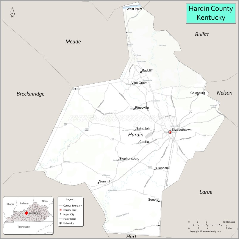
About Hardin County Map, Kentucky: The map showing the county boundary, county seat, major cities, highways, water bodies and neighbouring counties.
More Kentucky Maps & Info
Map of Hardin County, Kentucky
Hardin County is a county located in the U.S. state of Kentucky. It's county seat is Elizabethtown. As per 2020 census, the population of Hardin County is 111607 people and population density is square miles. According to the United States Census Bureau, the county has a total area of 628 sq mi (1,627 km2). Hardin County was established on 1792.
Hardin County Facts
| Continent | North America |
| Country | United States |
| State | Kentucky |
| County Seat | Elizabethtown |
| Largest City/Town | Elizabethtown |
| Established | 1792 |
| Total Area | 630 sq mi (1,632 sq km) |
| Land Area | 623 sq mi (1,614 sq km) |
| Water Area | 7 sq mi (18 sq km) |
| Population | 110,702 (Census 2020) |
| Population Density | 178 people per sq mi |
| Time Zone | Eastern Time Zone (ET) |
| Major Highways | Interstate 65, Western Kentucky Parkway, Bluegrass Parkway nearby area, U.S. Route 31W, U.S. Route 62 |
| Major Rivers | Ohio River nearby area, Rolling Fork River, Nolin River |
| Neighboring Counties | Meade County, Breckinridge County, Grayson County, Hart County, LaRue County, Bullitt County, Nelson County |
| Famous For | Fort Knox, military history, bourbon heritage, and Elizabethtown tourism |
| Top Attractions | Fort Knox, Abraham Lincoln Birthplace nearby area, Freeman Lake Park, Swope's Cars of Yesteryear Museum, Elizabethtown Nature Park |
| Official Website | Official Website |
About Hardin County, Kentucky
Hardin County is located in central Kentucky and was established in 1792 as one of Kentucky’s original counties. The county seat and largest city is Elizabethtown. Hardin County is known for Fort Knox, military heritage, historic attractions, bourbon culture, and its important location along major interstate transportation corridors. ([en.wikipedia.org](https://en.wikipedia.org/wiki/Hardin_County%2C_Kentucky?utm_source=chatgpt.com))
Cities and Communities in Hardin County, Kentucky
| City/Town | Population | Latitude & Longitude |
|---|---|---|
| Elizabethtown (county seat) | 31,000+ | 37.6939°N, 85.8591°W |
| Radcliff | 24,000+ | 37.8403°N, 85.9491°W |
| Vine Grove | 6,000+ | 37.8103°N, 85.9816°W |
| West Point | 900+ | 37.9978°N, 85.9494°W |
| Sonora | 500+ | 37.5204°N, 85.8913°W |
| Upton Nearby Area | Regional Community | 37.4678°N, 85.9048°W |
| Cecilia | Unincorporated | 37.6684°N, 85.9575°W |
| Rineyville | Unincorporated | 37.7521°N, 85.9725°W |
Best Golf Courses in Hardin County, Kentucky
| Golf Course | Location | Latitude & Longitude |
|---|---|---|
| Heartland Golf Club | Elizabethtown | 37.7154°N, 85.8610°W |
| Pine Valley Golf Course | Fort Knox Area | 37.8897°N, 85.9792°W |
| Elizabethtown Country Club | Elizabethtown | 37.7215°N, 85.8910°W |
| Doe Valley Golf Course | Nearby Brandenburg | 37.9874°N, 86.1088°W |
What are Major Roads and Highways in Hardin County
Major highways connect Hardin County with Louisville, Nashville, and central Kentucky communities.
- Interstate 65 - major north-south interstate connecting Louisville and Nashville
- Western Kentucky Parkway - important regional transportation corridor
- Bluegrass Parkway nearby area - major route toward central Kentucky and Lexington
- U.S. Route 31W - historic highway serving Elizabethtown and Fort Knox areas
- U.S. Route 62 - east-west roadway connecting regional communities
Neighboring Counties of Hardin County
- Meade County (northwest)
- Breckinridge County (west)
- Grayson County (southwest)
- Hart County (south)
- LaRue County (southeast)
- Bullitt County (north)
- Nelson County (east)
What are Top Attractions in Hardin County, Kentucky
The county features military landmarks, museums, parks, and family-friendly recreation attractions.
| Main Sight Name | City | Famous For |
|---|---|---|
| Fort Knox | Fort Knox Area | Military base and U.S. Bullion Depository |
| Abraham Lincoln Birthplace Nearby Area | Regional Area | Historic birthplace memorial and national park |
| Freeman Lake Park | Elizabethtown | Walking trails, fishing, and picnic areas |
| Swope's Cars of Yesteryear Museum | Elizabethtown | Classic automobile museum and exhibits |
| Elizabethtown Nature Park | Elizabethtown | Hiking trails and outdoor recreation |
| Historic Downtown Elizabethtown | Elizabethtown | Restaurants, boutiques, and historic architecture |
| General George Patton Museum | Fort Knox Area | Military history and armored warfare exhibits |
| Boundary Oak Distillery | Radcliff Area | Bourbon tasting and Kentucky spirits |
| Saunders Springs Nature Preserve | Radcliff | Nature trails and scenic outdoor landscapes |
| Sportsman Lake Park | Radcliff Area | Fishing and family recreation activities |
Distance from Hardin County to Nearby Cities
The following distances are measured by road (driving).
- Elizabethtown to Louisville, Kentucky - 44 mi (71 km)
- Elizabethtown to Bowling Green, Kentucky - 68 mi (109 km)
- Elizabethtown to Lexington, Kentucky - 92 mi (148 km)
- Elizabethtown to Nashville, Tennessee - 135 mi (217 km)
- Elizabethtown to Owensboro, Kentucky - 82 mi (132 km)
- Elizabethtown to Cincinnati, Ohio - 147 mi (237 km)
- Elizabethtown to Indianapolis, Indiana - 148 mi (238 km)
- Elizabethtown to Evansville, Indiana - 125 mi (201 km)
- Elizabethtown to Knoxville, Tennessee - 225 mi (362 km)
- Elizabethtown to St. Louis, Missouri - 261 mi (420 km)
- Elizabethtown to Chicago, Illinois - 322 mi (518 km)
- Elizabethtown to Atlanta, Georgia - 364 mi (586 km)
References
- Hardin County Official Website
- Hardin County, Kentucky - Wikipedia
- U.S. Census Bureau QuickFacts
- Elizabethtown Tourism
- Fort Knox Official Website
- Adair County Map
- Allen County Map
- Anderson County Map
- Ballard County Map
- Barren County Map
- Bath County Map
- Bell County Map
- Boone County Map
- Bourbon County Map
- Boyd County Map
- Boyle County Map
- Bracken County Map
- Breathitt County Map
- Breckinridge County Map
- Bullitt County Map
- Butler County Map
- Caldwell County Map
- Calloway County Map
- Campbell County Map
- Carlisle County Map
- Carroll County Map
- Carter County Map
- Casey County Map
- Christian County Map
- Clark County Map
- Clay County Map
- Clinton County Map
- Crittenden County Map
- Cumberland County Map
- Daviess County Map
- Edmonson County Map
- Elliott County Map
- Estill County Map
- Fayette County Map
- Fleming County Map
- Floyd County Map
- Franklin County Map
- Fulton County Map
- Gallatin County Map
- Garrard County Map
- Grant County Map
- Graves County Map
- Grayson County Map
- Green County Map
- Greenup County Map
- Hancock County Map
- Hardin County Map
- Harlan County Map
- Harrison County Map
- Hart County Map
- Henderson County Map
- Henry County Map
- Hickman County Map
- Hopkins County Map
- Jackson County Map
- Jefferson County Map
- Jessamine County Map
- Johnson County Map
- Kenton County Map
- Knott County Map
- Knox County Map
- LaRue County Map
- Laurel County Map
- Lawrence County Map
- Lee County Map
- Leslie County Map
- Letcher County Map
- Lewis County Map
- Lincoln County Map
- Livingston County Map
- Logan County Map
- Lyon County Map
- McCracken County Map
- McCreary County Map
- McLean County Map
- Madison County Map
- Magoffin County Map
- Marion County Map
- Marshall County Map
- Martin County Map
- Mason County Map
- Meade County Map
- Menifee County Map
- Mercer County Map
- Metcalfe County Map
- Monroe County Map
- Montgomery County Map
- Morgan County Map
- Muhlenberg County Map
- Nelson County Map
- Nicholas County Map
- Ohio County Map
- Oldham County Map
- Owen County Map
- Owsley County Map
- Pendleton County Map
- Perry County Map
- Pike County Map
- Powell County Map
- Pulaski County Map
- Robertson County Map
- Rockcastle County Map
- Rowan County Map
- Russell County Map
- Scott County Map
- Shelby County Map
- Simpson County Map
- Spencer County Map
- Taylor County Map
- Todd County Map
- Trigg County Map
- Trimble County Map
- Union County Map
- Warren County Map
- Washington County Map
- Wayne County Map
- Webster County Map
- Whitley County Map
- Wolfe County Map
- Woodford County Map
- Alabama Counties
- Alaska boroughs
- Arizona Counties
- Arkansas Counties
- California County Map
- Colorado Counties
- Connecticut Counties
- Delaware Counties
- Florida County Map
- Georgia County Map
- Hawaii Counties
- Idaho Counties
- Illinois Counties
- Indiana Counties
- Iowa Counties
- Kansas Counties
- Kentucky Counties
- Louisiana Counties
- Maine Counties
- Maryland Counties
- Massachusetts Counties
- Michigan County Map
- Minnesota Counties
- Mississippi Counties
- Missouri Counties
- Montana Counties
- Nebraska Counties
- Nevada Counties
- New York Counties
- New Hampshire Counties
- New Jersey Counties
- New Mexico Counties
- North Carolina Counties
- North Dakota Counties
- Ohio County Map
- Oklahoma Counties
- Oregon Counties
- Pennsylvania Counties
- Rhode Island Counties
- South Carolina Counties
- South Dakota Counties
- Map of Tennessee
- Texas County Map
- Utah Counties
- Vermont Counties
- Virginia Counties
- Washington Counties
- West Virginia Counties
- Wisconsin Counties
- Wyoming Counties