Map of Menifee County - Menifee County is a county located in the U.S. state of Kentucky. Menifee County Map showing cities, highways, important places and water bodies. Get Where is Menifee County located in the map, major cities in Menifee county, population, areas, and places of interest.
Map of Menifee County, Kentucky
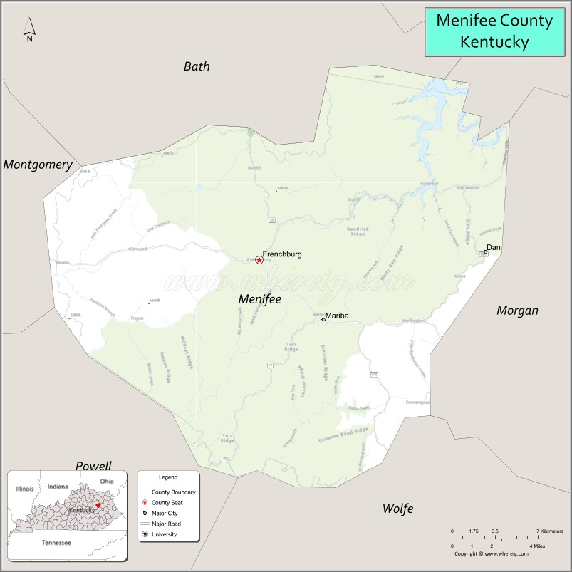
About Menifee County Map, Kentucky: The map showing the county boundary, county seat, major cities, highways, water bodies and neighbouring counties.
More Kentucky Maps & Info
Map of Menifee County, Kentucky
Menifee County is a county located in the U.S. state of Kentucky. It's county seat is Frenchburg. As per 2020 census, the population of Menifee County is 6194 people and population density is square miles. According to the United States Census Bureau, the county has a total area of 204 sq mi (528 km2). Menifee County was established on 1869.
Menifee County Facts
| Continent | North America |
| Country | United States |
| State | Kentucky |
| County Seat | Frenchburg |
| Largest City/Town | Frenchburg |
| Established | 1869 |
| Total Area | 204 sq mi (528 sq km) |
| Land Area | 204 sq mi (528 sq km) |
| Water Area | 0.3 sq mi (1 sq km) |
| Population | 6,113 (Census 2020) |
| Population Density | 30 people per sq mi |
| Time Zone | Eastern Time Zone (ET) |
| Major Highways | U.S. Route 460, Kentucky Route 36, Kentucky Route 1274, Kentucky Route 715 nearby area |
| Major Rivers | Red River, Licking River tributaries |
| Neighboring Counties | Powell County, Wolfe County, Morgan County, Montgomery County, Bath County |
| Famous For | Daniel Boone National Forest, Red River Gorge nearby area, scenic mountain landscapes, and outdoor recreation |
| Top Attractions | Cave Run Lake nearby area, Red River Gorge nearby area, Daniel Boone National Forest, Frenchburg Overlook, Broke Leg Falls |
| Official Website | Official Website |
About Menifee County, Kentucky
Menifee County is located in eastern Kentucky within the Appalachian foothills and was established in 1869. The county seat and largest city is Frenchburg. Menifee County is known for forested mountain scenery, outdoor recreation opportunities, sandstone cliffs, waterfalls, and proximity to Red River Gorge and the Daniel Boone National Forest. ([en.wikipedia.org](https://en.wikipedia.org/wiki/Menifee_County%2C_Kentucky?utm_source=chatgpt.com))
Cities and Communities in Menifee County, Kentucky
| City/Town | Population | Latitude & Longitude |
|---|---|---|
| Frenchburg (county seat) | 800+ | 37.9501°N, 83.6255°W |
| Denniston | Rural Community | 37.9174°N, 83.5408°W |
| Means | Small Community | 38.0282°N, 83.7425°W |
| Mariba | Historic Community | 37.9978°N, 83.5851°W |
| Rothwell | Unincorporated | 37.9220°N, 83.6942°W |
| Scranton | Mountain Community | 37.9865°N, 83.5160°W |
| Zachariah | Rural Area | 37.8604°N, 83.6431°W |
| Wellington Nearby Area | Regional Community | 38.1255°N, 83.5115°W |
Best Golf Courses in Menifee County, Kentucky
| Golf Course | Location | Latitude & Longitude |
|---|---|---|
| Eagle Trace Golf Course | Nearby Morehead | 38.1856°N, 83.4324°W |
| Raven Rock Golf Course | Nearby Jenkins | 37.1834°N, 82.6322°W |
| Winchester Country Club | Nearby Winchester | 37.9910°N, 84.1528°W |
| Gibson Bay Golf Course | Nearby Richmond | 37.7660°N, 84.3018°W |
What are Major Roads and Highways in Menifee County
Major highways connect Menifee County with eastern Kentucky mountain communities, Lexington, and regional recreation destinations.
- U.S. Route 460 - major east-west highway through Frenchburg and surrounding communities
- Kentucky Route 36 - scenic roadway connecting rural Appalachian areas
- Kentucky Route 1274 - regional connector serving mountain communities
- Kentucky Route 715 nearby area - access route toward Red River Gorge recreation areas
Neighboring Counties of Menifee County
- Powell County (south)
- Wolfe County (southeast)
- Morgan County (east)
- Montgomery County (northwest)
- Bath County (north)
What are Top Attractions in Menifee County, Kentucky
The county offers hiking, waterfalls, sandstone cliffs, forest recreation, and scenic Appalachian landscapes.
| Main Sight Name | City | Famous For |
|---|---|---|
| Cave Run Lake Nearby Area | Regional Area | Boating, fishing, and camping recreation |
| Red River Gorge Nearby Area | Regional Area | Rock climbing, hiking, and sandstone arches |
| Daniel Boone National Forest | Countywide | Forest trails, wildlife viewing, and camping |
| Frenchburg Overlook | Frenchburg | Scenic mountain and valley views |
| Broke Leg Falls | Countywide | Waterfall hiking and photography |
| Red River Recreation Areas | Countywide | Fishing, kayaking, and outdoor activities |
| Mountain Scenic Drives | Countywide | Appalachian landscapes and countryside views |
| Historic Downtown Frenchburg | Frenchburg | Small-town atmosphere and local businesses |
| Hiking and Nature Trails | Countywide | Outdoor exploration and forest recreation |
| Community Heritage Festivals | Frenchburg Area | Local traditions and seasonal celebrations |
Distance from Menifee County to Nearby Cities
The following distances are measured by road (driving).
- Frenchburg to Morehead, Kentucky - 29 mi (47 km)
- Frenchburg to Winchester, Kentucky - 43 mi (69 km)
- Frenchburg to Lexington, Kentucky - 67 mi (108 km)
- Frenchburg to Huntington, West Virginia - 101 mi (163 km)
- Frenchburg to Charleston, West Virginia - 130 mi (209 km)
- Frenchburg to Louisville, Kentucky - 147 mi (237 km)
- Frenchburg to Cincinnati, Ohio - 126 mi (203 km)
- Frenchburg to Columbus, Ohio - 179 mi (288 km)
- Frenchburg to Knoxville, Tennessee - 201 mi (323 km)
- Frenchburg to Indianapolis, Indiana - 237 mi (381 km)
- Frenchburg to Nashville, Tennessee - 247 mi (398 km)
- Frenchburg to Chicago, Illinois - 363 mi (584 km)
References
- Menifee County Official Website
- Menifee County, Kentucky - Wikipedia
- U.S. Census Bureau QuickFacts
- Daniel Boone National Forest
- Red River Gorge Tourism
- Adair County Map
- Allen County Map
- Anderson County Map
- Ballard County Map
- Barren County Map
- Bath County Map
- Bell County Map
- Boone County Map
- Bourbon County Map
- Boyd County Map
- Boyle County Map
- Bracken County Map
- Breathitt County Map
- Breckinridge County Map
- Bullitt County Map
- Butler County Map
- Caldwell County Map
- Calloway County Map
- Campbell County Map
- Carlisle County Map
- Carroll County Map
- Carter County Map
- Casey County Map
- Christian County Map
- Clark County Map
- Clay County Map
- Clinton County Map
- Crittenden County Map
- Cumberland County Map
- Daviess County Map
- Edmonson County Map
- Elliott County Map
- Estill County Map
- Fayette County Map
- Fleming County Map
- Floyd County Map
- Franklin County Map
- Fulton County Map
- Gallatin County Map
- Garrard County Map
- Grant County Map
- Graves County Map
- Grayson County Map
- Green County Map
- Greenup County Map
- Hancock County Map
- Hardin County Map
- Harlan County Map
- Harrison County Map
- Hart County Map
- Henderson County Map
- Henry County Map
- Hickman County Map
- Hopkins County Map
- Jackson County Map
- Jefferson County Map
- Jessamine County Map
- Johnson County Map
- Kenton County Map
- Knott County Map
- Knox County Map
- LaRue County Map
- Laurel County Map
- Lawrence County Map
- Lee County Map
- Leslie County Map
- Letcher County Map
- Lewis County Map
- Lincoln County Map
- Livingston County Map
- Logan County Map
- Lyon County Map
- McCracken County Map
- McCreary County Map
- McLean County Map
- Madison County Map
- Magoffin County Map
- Marion County Map
- Marshall County Map
- Martin County Map
- Mason County Map
- Meade County Map
- Menifee County Map
- Mercer County Map
- Metcalfe County Map
- Monroe County Map
- Montgomery County Map
- Morgan County Map
- Muhlenberg County Map
- Nelson County Map
- Nicholas County Map
- Ohio County Map
- Oldham County Map
- Owen County Map
- Owsley County Map
- Pendleton County Map
- Perry County Map
- Pike County Map
- Powell County Map
- Pulaski County Map
- Robertson County Map
- Rockcastle County Map
- Rowan County Map
- Russell County Map
- Scott County Map
- Shelby County Map
- Simpson County Map
- Spencer County Map
- Taylor County Map
- Todd County Map
- Trigg County Map
- Trimble County Map
- Union County Map
- Warren County Map
- Washington County Map
- Wayne County Map
- Webster County Map
- Whitley County Map
- Wolfe County Map
- Woodford County Map
- Alabama Counties
- Alaska boroughs
- Arizona Counties
- Arkansas Counties
- California County Map
- Colorado Counties
- Connecticut Counties
- Delaware Counties
- Florida County Map
- Georgia County Map
- Hawaii Counties
- Idaho Counties
- Illinois Counties
- Indiana Counties
- Iowa Counties
- Kansas Counties
- Kentucky Counties
- Louisiana Counties
- Maine Counties
- Maryland Counties
- Massachusetts Counties
- Michigan County Map
- Minnesota Counties
- Mississippi Counties
- Missouri Counties
- Montana Counties
- Nebraska Counties
- Nevada Counties
- New York Counties
- New Hampshire Counties
- New Jersey Counties
- New Mexico Counties
- North Carolina Counties
- North Dakota Counties
- Ohio County Map
- Oklahoma Counties
- Oregon Counties
- Pennsylvania Counties
- Rhode Island Counties
- South Carolina Counties
- South Dakota Counties
- Map of Tennessee
- Texas County Map
- Utah Counties
- Vermont Counties
- Virginia Counties
- Washington Counties
- West Virginia Counties
- Wisconsin Counties
- Wyoming Counties