Map of Hart County - Hart County is a county located in the U.S. state of Kentucky. Hart County Map showing cities, highways, important places and water bodies. Get Where is Hart County located in the map, major cities in Hart county, population, areas, and places of interest.
Map of Hart County, Kentucky
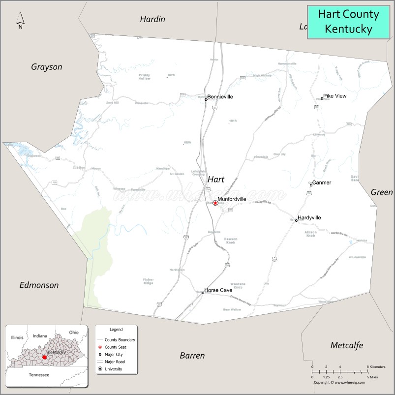
About Hart County Map, Kentucky: The map showing the county boundary, county seat, major cities, highways, water bodies and neighbouring counties.
More Kentucky Maps & Info
Map of Hart County, Kentucky
Hart County is a county located in the U.S. state of Kentucky. It's county seat is Munfordville. As per 2020 census, the population of Hart County is 19460 people and population density is square miles. According to the United States Census Bureau, the county has a total area of 416 sq mi (1,077 km2). Hart County was established on 1819.
Hart County Facts
| Continent | North America |
| Country | United States |
| State | Kentucky |
| County Seat | Munfordville |
| Largest City/Town | Munfordville |
| Established | 1819 |
| Total Area | 421 sq mi (1,090 sq km) |
| Land Area | 412 sq mi (1,067 sq km) |
| Water Area | 8.7 sq mi (23 sq km) |
| Population | 19,288 (Census 2020) |
| Population Density | 47 people per sq mi |
| Time Zone | Central Time Zone (CT) |
| Major Highways | Interstate 65, U.S. Route 31W, Kentucky Route 88, Kentucky Route 357 |
| Major Rivers | Green River, Nolin River |
| Neighboring Counties | Hardin County, Grayson County, Edmonson County, Barren County, Metcalfe County, LaRue County |
| Famous For | Mammoth Cave nearby area, Green River recreation, Civil War history, and scenic Kentucky countryside |
| Top Attractions | Mammoth Cave National Park nearby area, Kentucky Down Under Adventure Zoo, Munfordville Historic District, Big Buffalo Crossing Canoe & Kayak, Cub Run Cave |
| Official Website | Official Website |
About Hart County, Kentucky
Hart County is located in central Kentucky and was established in 1819. The county seat and largest city is Munfordville. Hart County is known for its proximity to Mammoth Cave National Park, outdoor recreation along the Green River, scenic farmland, and historic Civil War landmarks. ([en.wikipedia.org](https://en.wikipedia.org/wiki/Hart_County%2C_Kentucky?utm_source=chatgpt.com))
Cities and Communities in Hart County, Kentucky
| City/Town | Population | Latitude & Longitude |
|---|---|---|
| Munfordville (county seat) | 1,600+ | 37.2720°N, 85.8919°W |
| Horse Cave | 2,300+ | 37.1798°N, 85.9064°W |
| Bonnieville | 300+ | 37.3789°N, 85.8977°W |
| Munfordville Crossing | Historic Community | 37.2705°N, 85.8944°W |
| Cub Run | Unincorporated | 37.2925°N, 86.0341°W |
| Linwood | Rural Community | 37.1554°N, 85.8552°W |
| Priceville | Historic Community | 37.3381°N, 85.8294°W |
| Uno | Unincorporated | 37.1436°N, 85.9425°W |
Best Golf Courses in Hart County, Kentucky
| Golf Course | Location | Latitude & Longitude |
|---|---|---|
| Cave Valley Golf Club | Horse Cave | 37.1818°N, 85.9151°W |
| Shady Hollow Golf Course | Cub Run Area | 37.2827°N, 86.0875°W |
| CrossWinds Golf Course | Nearby Bowling Green | 36.9718°N, 86.4190°W |
| Heartland Golf Club | Nearby Elizabethtown | 37.7154°N, 85.8610°W |
What are Major Roads and Highways in Hart County
Major highways connect Hart County with Louisville, Bowling Green, and central Kentucky communities.
- Interstate 65 - major north-south interstate through Hart County connecting Louisville and Nashville
- U.S. Route 31W - historic highway serving Munfordville and Horse Cave
- Kentucky Route 88 - regional connector route through rural countryside areas
- Kentucky Route 357 - scenic roadway linking local communities and recreation areas
Neighboring Counties of Hart County
- Hardin County (north)
- Grayson County (west)
- Edmonson County (southwest)
- Barren County (south)
- Metcalfe County (southeast)
- LaRue County (northeast)
What are Top Attractions in Hart County, Kentucky
The county features cave attractions, outdoor recreation, historic sites, and scenic river landscapes.
| Main Sight Name | City | Famous For |
|---|---|---|
| Mammoth Cave National Park Nearby Area | Horse Cave Area | World-famous cave systems and hiking trails |
| Kentucky Down Under Adventure Zoo | Horse Cave | Australian-themed wildlife attraction and cave tours |
| Munfordville Historic District | Munfordville | Civil War history and historic architecture |
| Big Buffalo Crossing Canoe & Kayak | Munfordville Area | Green River canoeing and outdoor recreation |
| Cub Run Cave | Cub Run | Underground cave exploration and geology |
| Horse Cave Theatre | Horse Cave | Community performances and cultural events |
| Green River Scenic Areas | Countywide | Fishing, boating, and nature photography |
| Battle for the Bridge Historic Preserve | Munfordville | Civil War battlefield history |
| Hidden River Cave | Horse Cave | Underground cave tours and museum exhibits |
| Rural Scenic Drives | Countywide | Rolling farmland and countryside landscapes |
Distance from Hart County to Nearby Cities
The following distances are measured by road (driving).
- Munfordville to Bowling Green, Kentucky - 43 mi (69 km)
- Horse Cave to Elizabethtown, Kentucky - 47 mi (76 km)
- Munfordville to Louisville, Kentucky - 83 mi (134 km)
- Horse Cave to Nashville, Tennessee - 103 mi (166 km)
- Munfordville to Lexington, Kentucky - 118 mi (190 km)
- Horse Cave to Owensboro, Kentucky - 103 mi (166 km)
- Munfordville to Evansville, Indiana - 132 mi (212 km)
- Horse Cave to Cincinnati, Ohio - 176 mi (283 km)
- Munfordville to Indianapolis, Indiana - 187 mi (301 km)
- Horse Cave to Knoxville, Tennessee - 205 mi (330 km)
- Munfordville to St. Louis, Missouri - 270 mi (435 km)
- Horse Cave to Atlanta, Georgia - 306 mi (492 km)
References
- Hart County Official Website
- Hart County, Kentucky - Wikipedia
- U.S. Census Bureau QuickFacts
- Mammoth Cave National Park
- Kentucky Down Under Adventure Zoo
- Adair County Map
- Allen County Map
- Anderson County Map
- Ballard County Map
- Barren County Map
- Bath County Map
- Bell County Map
- Boone County Map
- Bourbon County Map
- Boyd County Map
- Boyle County Map
- Bracken County Map
- Breathitt County Map
- Breckinridge County Map
- Bullitt County Map
- Butler County Map
- Caldwell County Map
- Calloway County Map
- Campbell County Map
- Carlisle County Map
- Carroll County Map
- Carter County Map
- Casey County Map
- Christian County Map
- Clark County Map
- Clay County Map
- Clinton County Map
- Crittenden County Map
- Cumberland County Map
- Daviess County Map
- Edmonson County Map
- Elliott County Map
- Estill County Map
- Fayette County Map
- Fleming County Map
- Floyd County Map
- Franklin County Map
- Fulton County Map
- Gallatin County Map
- Garrard County Map
- Grant County Map
- Graves County Map
- Grayson County Map
- Green County Map
- Greenup County Map
- Hancock County Map
- Hardin County Map
- Harlan County Map
- Harrison County Map
- Hart County Map
- Henderson County Map
- Henry County Map
- Hickman County Map
- Hopkins County Map
- Jackson County Map
- Jefferson County Map
- Jessamine County Map
- Johnson County Map
- Kenton County Map
- Knott County Map
- Knox County Map
- LaRue County Map
- Laurel County Map
- Lawrence County Map
- Lee County Map
- Leslie County Map
- Letcher County Map
- Lewis County Map
- Lincoln County Map
- Livingston County Map
- Logan County Map
- Lyon County Map
- McCracken County Map
- McCreary County Map
- McLean County Map
- Madison County Map
- Magoffin County Map
- Marion County Map
- Marshall County Map
- Martin County Map
- Mason County Map
- Meade County Map
- Menifee County Map
- Mercer County Map
- Metcalfe County Map
- Monroe County Map
- Montgomery County Map
- Morgan County Map
- Muhlenberg County Map
- Nelson County Map
- Nicholas County Map
- Ohio County Map
- Oldham County Map
- Owen County Map
- Owsley County Map
- Pendleton County Map
- Perry County Map
- Pike County Map
- Powell County Map
- Pulaski County Map
- Robertson County Map
- Rockcastle County Map
- Rowan County Map
- Russell County Map
- Scott County Map
- Shelby County Map
- Simpson County Map
- Spencer County Map
- Taylor County Map
- Todd County Map
- Trigg County Map
- Trimble County Map
- Union County Map
- Warren County Map
- Washington County Map
- Wayne County Map
- Webster County Map
- Whitley County Map
- Wolfe County Map
- Woodford County Map
- Alabama Counties
- Alaska boroughs
- Arizona Counties
- Arkansas Counties
- California County Map
- Colorado Counties
- Connecticut Counties
- Delaware Counties
- Florida County Map
- Georgia County Map
- Hawaii Counties
- Idaho Counties
- Illinois Counties
- Indiana Counties
- Iowa Counties
- Kansas Counties
- Kentucky Counties
- Louisiana Counties
- Maine Counties
- Maryland Counties
- Massachusetts Counties
- Michigan County Map
- Minnesota Counties
- Mississippi Counties
- Missouri Counties
- Montana Counties
- Nebraska Counties
- Nevada Counties
- New York Counties
- New Hampshire Counties
- New Jersey Counties
- New Mexico Counties
- North Carolina Counties
- North Dakota Counties
- Ohio County Map
- Oklahoma Counties
- Oregon Counties
- Pennsylvania Counties
- Rhode Island Counties
- South Carolina Counties
- South Dakota Counties
- Map of Tennessee
- Texas County Map
- Utah Counties
- Vermont Counties
- Virginia Counties
- Washington Counties
- West Virginia Counties
- Wisconsin Counties
- Wyoming Counties