Map of Whitley County - Whitley County is a county located in the U.S. state of Kentucky. Whitley County Map showing cities, highways, important places and water bodies. Get Where is Whitley County located in the map, major cities in Whitley county, population, areas, and places of interest.
Map of Whitley County, Kentucky
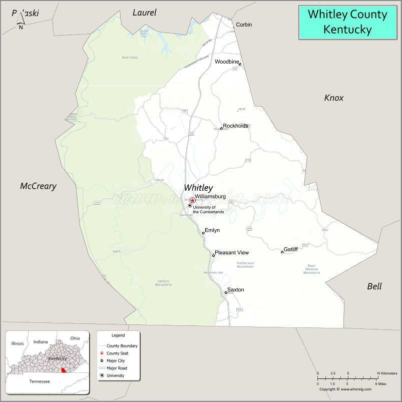
About Whitley County Map, Kentucky: The map showing the county boundary, county seat, major cities, highways, water bodies and neighbouring counties.
More Kentucky Maps & Info
Map of Whitley County, Kentucky
Avoyelles Parish County is a county located in the U.S. state of Louisiana. It`s county seat is Marksville. As per 2020 census, the population of Avoyelles Parish County was 39236 and population density of Avoyelles Parish was square miles. According to the United States Census Bureau, the county has a total area of 866 sq mi (2,243 km2). Avoyelles Parish County was established on 1807.
Whitley County Facts
| Continent | North America |
| Country | United States |
| State | Kentucky |
| County Seat | Williamsburg |
| Largest City/Town | Corbin |
| Established | 1818 |
| Total Area | 445 sq mi (1,153 sq km) |
| Land Area | 438 sq mi (1,134 sq km) |
| Water Area | 7.3 sq mi (19 sq km) |
| Population | 36,712 (Census 2020) |
| Population Density | 84 people per sq mi |
| Time Zone | Eastern Time Zone (ET) |
| Major Highways | Interstate 75, U.S. Route 25W, Kentucky Route 92, Cumberland Parkway nearby area |
| Major Rivers | Cumberland River |
| Neighboring Counties | Knox County, Laurel County, McCreary County, Bell County, Campbell County (TN), Claiborne County (TN) |
| Famous For | Cumberland Falls nearby area, University of the Cumberlands, Appalachian heritage, and outdoor recreation |
| Top Attractions | Cumberland Falls State Resort Park nearby area, University of the Cumberlands, Kentucky Splash WaterPark, Daniel Boone National Forest, Historic Downtown Corbin |
| Official Website | Official Website |
About Whitley County, Kentucky
Whitley County is located in southeastern Kentucky along the Tennessee border and was established in 1818. The county seat is Williamsburg while Corbin is the largest city. Whitley County is known for Appalachian mountain scenery, Cumberland Falls nearby attractions, higher education at the University of the Cumberlands, and outdoor recreation opportunities throughout the Daniel Boone National Forest region. ([en.wikipedia.org](https://en.wikipedia.org/wiki/Whitley_County,_Kentucky?utm_source=chatgpt.com))
Cities and Communities in Whitley County, Kentucky
| City/Town | Population | Latitude & Longitude |
|---|---|---|
| Corbin | 7,500+ | 36.9487°N, 84.0969°W |
| Williamsburg (county seat) | 5,200+ | 36.7434°N, 84.1591°W |
| Pleasant View | Rural Community | 36.8148°N, 84.1845°W |
| Rockholds | Historic Community | 36.8290°N, 84.0834°W |
| Saxton | Mountain Area | 36.7062°N, 84.2605°W |
| Emlyn | Small Community | 36.6968°N, 84.2027°W |
| Nevisdale | Coal Mining Community | 36.6058°N, 84.0674°W |
| Jellico Creek Area | Scenic Area | 36.6214°N, 84.1136°W |
Best Golf Courses in Whitley County, Kentucky
| Golf Course | Location | Latitude & Longitude |
|---|---|---|
| Laurel River Lake Golf Area | Nearby Corbin | 36.9405°N, 84.1413°W |
| London Country Club | Nearby London | 37.0868°N, 84.0914°W |
| Crooked Creek Golf Course | Nearby London | 37.0972°N, 84.0525°W |
| Indian Springs Country Club | Nearby Barbourville | 36.8664°N, 83.8871°W |
What are Major Roads and Highways in Whitley County
Major highways connect Whitley County with Lexington, Knoxville, and important Appalachian tourism destinations.
- Interstate 75 - major north-south interstate through Corbin and Williamsburg
- U.S. Route 25W - historic regional highway serving local communities
- Kentucky Route 92 - scenic route through mountain landscapes and rural areas
- Cumberland Parkway nearby area - important connector corridor for south-central Kentucky
Neighboring Counties of Whitley County
- Knox County (north)
- Laurel County (northwest)
- McCreary County (west)
- Bell County (east)
- Campbell County, Tennessee (southwest)
- Claiborne County, Tennessee (south)
What are Top Attractions in Whitley County, Kentucky
The county offers waterfalls, hiking trails, university attractions, outdoor recreation, and scenic Appalachian mountain experiences.
| Main Sight Name | City | Famous For |
|---|---|---|
| Cumberland Falls State Resort Park Nearby Area | Regional Area | Waterfalls, hiking, and the famous Moonbow phenomenon |
| University of the Cumberlands | Williamsburg | Historic university campus and educational heritage |
| Kentucky Splash WaterPark | Williamsburg | Family water recreation and summer entertainment |
| Daniel Boone National Forest | Countywide | Hiking, camping, wildlife viewing, and forest recreation |
| Historic Downtown Corbin | Corbin | Restaurants, shops, and Appalachian culture |
| Laurel River Lake Nearby Area | Regional Area | Fishing, boating, and scenic lake recreation |
| Harland Sanders Café and Museum Nearby Area | Corbin | KFC history and roadside Americana |
| Appalachian Scenic Drives | Countywide | Mountain landscapes and countryside photography |
| Outdoor Nature Trails | Countywide | Hiking and wildlife exploration |
| Community Festivals and Events | Williamsburg Area | Local traditions and seasonal celebrations |
Distance from Whitley County to Nearby Cities
The following distances are measured by road (driving).
- Williamsburg to Knoxville, Tennessee - 68 mi (109 km)
- Williamsburg to Lexington, Kentucky - 112 mi (180 km)
- Williamsburg to Somerset, Kentucky - 56 mi (90 km)
- Williamsburg to Chattanooga, Tennessee - 164 mi (264 km)
- Williamsburg to Louisville, Kentucky - 178 mi (286 km)
- Williamsburg to Nashville, Tennessee - 201 mi (323 km)
- Williamsburg to Cincinnati, Ohio - 214 mi (344 km)
- Williamsburg to Atlanta, Georgia - 246 mi (396 km)
- Williamsburg to Columbus, Ohio - 290 mi (467 km)
- Williamsburg to Indianapolis, Indiana - 297 mi (478 km)
- Williamsburg to Charlotte, North Carolina - 257 mi (414 km)
- Williamsburg to Chicago, Illinois - 442 mi (711 km)
References
- Whitley County Fiscal Court
- Whitley County, Kentucky - Wikipedia
- U.S. Census Bureau QuickFacts
- Cumberland Falls State Resort Park
- University of the Cumberlands
- Adair County Map
- Allen County Map
- Anderson County Map
- Ballard County Map
- Barren County Map
- Bath County Map
- Bell County Map
- Boone County Map
- Bourbon County Map
- Boyd County Map
- Boyle County Map
- Bracken County Map
- Breathitt County Map
- Breckinridge County Map
- Bullitt County Map
- Butler County Map
- Caldwell County Map
- Calloway County Map
- Campbell County Map
- Carlisle County Map
- Carroll County Map
- Carter County Map
- Casey County Map
- Christian County Map
- Clark County Map
- Clay County Map
- Clinton County Map
- Crittenden County Map
- Cumberland County Map
- Daviess County Map
- Edmonson County Map
- Elliott County Map
- Estill County Map
- Fayette County Map
- Fleming County Map
- Floyd County Map
- Franklin County Map
- Fulton County Map
- Gallatin County Map
- Garrard County Map
- Grant County Map
- Graves County Map
- Grayson County Map
- Green County Map
- Greenup County Map
- Hancock County Map
- Hardin County Map
- Harlan County Map
- Harrison County Map
- Hart County Map
- Henderson County Map
- Henry County Map
- Hickman County Map
- Hopkins County Map
- Jackson County Map
- Jefferson County Map
- Jessamine County Map
- Johnson County Map
- Kenton County Map
- Knott County Map
- Knox County Map
- LaRue County Map
- Laurel County Map
- Lawrence County Map
- Lee County Map
- Leslie County Map
- Letcher County Map
- Lewis County Map
- Lincoln County Map
- Livingston County Map
- Logan County Map
- Lyon County Map
- McCracken County Map
- McCreary County Map
- McLean County Map
- Madison County Map
- Magoffin County Map
- Marion County Map
- Marshall County Map
- Martin County Map
- Mason County Map
- Meade County Map
- Menifee County Map
- Mercer County Map
- Metcalfe County Map
- Monroe County Map
- Montgomery County Map
- Morgan County Map
- Muhlenberg County Map
- Nelson County Map
- Nicholas County Map
- Ohio County Map
- Oldham County Map
- Owen County Map
- Owsley County Map
- Pendleton County Map
- Perry County Map
- Pike County Map
- Powell County Map
- Pulaski County Map
- Robertson County Map
- Rockcastle County Map
- Rowan County Map
- Russell County Map
- Scott County Map
- Shelby County Map
- Simpson County Map
- Spencer County Map
- Taylor County Map
- Todd County Map
- Trigg County Map
- Trimble County Map
- Union County Map
- Warren County Map
- Washington County Map
- Wayne County Map
- Webster County Map
- Whitley County Map
- Wolfe County Map
- Woodford County Map
- Alabama Counties
- Alaska boroughs
- Arizona Counties
- Arkansas Counties
- California County Map
- Colorado Counties
- Connecticut Counties
- Delaware Counties
- Florida County Map
- Georgia County Map
- Hawaii Counties
- Idaho Counties
- Illinois Counties
- Indiana Counties
- Iowa Counties
- Kansas Counties
- Kentucky Counties
- Louisiana Counties
- Maine Counties
- Maryland Counties
- Massachusetts Counties
- Michigan County Map
- Minnesota Counties
- Mississippi Counties
- Missouri Counties
- Montana Counties
- Nebraska Counties
- Nevada Counties
- New York Counties
- New Hampshire Counties
- New Jersey Counties
- New Mexico Counties
- North Carolina Counties
- North Dakota Counties
- Ohio County Map
- Oklahoma Counties
- Oregon Counties
- Pennsylvania Counties
- Rhode Island Counties
- South Carolina Counties
- South Dakota Counties
- Map of Tennessee
- Texas County Map
- Utah Counties
- Vermont Counties
- Virginia Counties
- Washington Counties
- West Virginia Counties
- Wisconsin Counties
- Wyoming Counties