Map of Harlan County - Harlan County is a county located in the U.S. state of Kentucky. Harlan County Map showing cities, highways, important places and water bodies. Get Where is Harlan County located in the map, major cities in Harlan county, population, areas, and places of interest.
Map of Harlan County, Kentucky
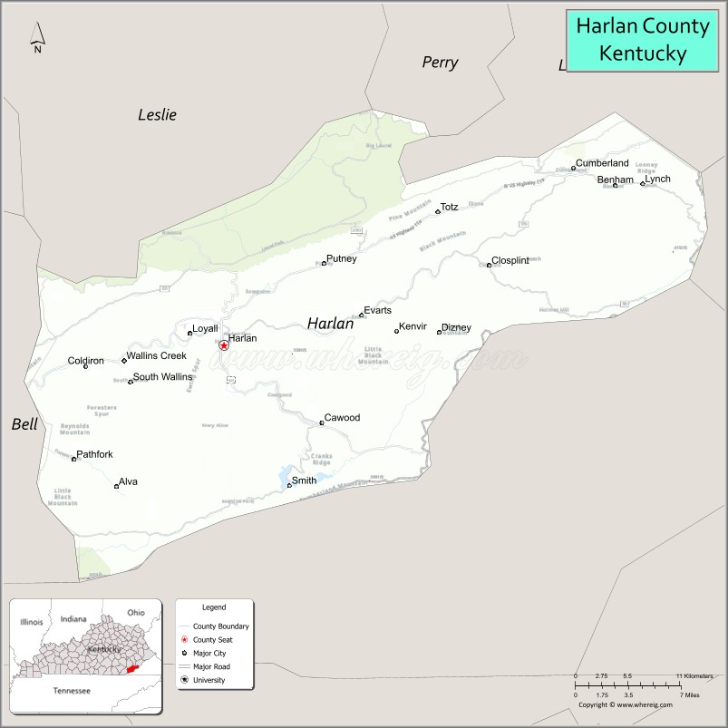
About Harlan County Map, Kentucky: The map showing the county boundary, county seat, major cities, highways, water bodies and neighbouring counties.
More Kentucky Maps & Info
Map of Harlan County, Kentucky
Harlan County is a county located in the U.S. state of Kentucky. It's county seat is Harlan. As per 2020 census, the population of Harlan County is 26164 people and population density is square miles. According to the United States Census Bureau, the county has a total area of 467 sq mi (1,210 km2). Harlan County was established on 1819.
Harlan County Facts
| Continent | North America |
| Country | United States |
| State | Kentucky |
| County Seat | Harlan |
| Largest City/Town | Harlan |
| Established | 1819 |
| Total Area | 468 sq mi (1,212 sq km) |
| Land Area | 466 sq mi (1,207 sq km) |
| Water Area | 2 sq mi (5 sq km) |
| Population | 26,831 (Census 2020) |
| Population Density | 58 people per sq mi |
| Time Zone | Eastern Time Zone (ET) |
| Major Highways | U.S. Route 421, U.S. Route 119, Kentucky Route 38, Kentucky Route 160 |
| Major Rivers | Cumberland River, Poor Fork Cumberland River |
| Neighboring Counties | Letcher County, Bell County, Leslie County, Perry County, Lee County (VA), Claiborne County (TN) |
| Famous For | Coal mining heritage, Appalachian culture, Black Mountain, and mountain recreation |
| Top Attractions | Black Mountain Off-Road Adventure Area, Kingdom Come State Park, Portal 31 Coal Mine Tour, Harlan Center, Pine Mountain scenery |
| Official Website | Official Website |
About Harlan County, Kentucky
Harlan County is located in southeastern Kentucky within the Appalachian Mountains and was established in 1819. The county seat and largest city is Harlan. Harlan County is famous for its coal mining history, mountain landscapes, Appalachian music traditions, and outdoor recreation opportunities surrounding Black Mountain and Pine Mountain. ([en.wikipedia.org](https://en.wikipedia.org/wiki/Harlan_County%2C_Kentucky?utm_source=chatgpt.com))
Cities and Communities in Harlan County, Kentucky
| City/Town | Population | Latitude & Longitude |
|---|---|---|
| Harlan (county seat) | 1,700+ | 36.8434°N, 83.3219°W |
| Cumberland | 2,000+ | 36.9784°N, 82.9885°W |
| Loyall | 700+ | 36.8523°N, 83.3527°W |
| Baxter | 500+ | 36.8679°N, 83.3178°W |
| Evarts | 900+ | 36.8651°N, 83.1960°W |
| Lynch | 700+ | 36.9729°N, 82.9157°W |
| Benham | 500+ | 36.9621°N, 82.9602°W |
| Wallins Creek | Historic Community | 36.8220°N, 83.3570°W |
Best Golf Courses in Harlan County, Kentucky
| Golf Course | Location | Latitude & Longitude |
|---|---|---|
| Sleepy Hollow Golf Course | Cumberland | 36.9770°N, 82.9986°W |
| Wasioto Winds Golf Course | Nearby Pineville | 36.7447°N, 83.6948°W |
| Pine Mountain State Resort Park Golf Course | Nearby Pineville | 36.7640°N, 83.6943°W |
| Clear Creek Golf Club | Nearby Bristol, Virginia | 36.6472°N, 82.1880°W |
What are Major Roads and Highways in Harlan County
Major highways connect Harlan County with eastern Kentucky, Tennessee, and Virginia mountain communities.
- U.S. Route 421 - major regional highway through Harlan and Appalachian mountain areas
- U.S. Route 119 - important transportation corridor linking coalfield communities
- Kentucky Route 38 - scenic mountain roadway serving eastern Harlan County
- Kentucky Route 160 - mountain route crossing Pine Mountain and connecting rural communities
Neighboring Counties of Harlan County
- Letcher County (north)
- Bell County (west)
- Leslie County (northwest)
- Perry County (northwest)
- Lee County, Virginia (east)
- Claiborne County, Tennessee (south)
What are Top Attractions in Harlan County, Kentucky
The county offers mountain recreation, coal mining history, scenic overlooks, and Appalachian cultural attractions.
| Main Sight Name | City | Famous For |
|---|---|---|
| Black Mountain Off-Road Adventure Area | Harlan Area | ATV trails and mountain recreation |
| Kingdom Come State Park | Cumberland | Mountain overlooks, hiking, and wildlife viewing |
| Portal 31 Coal Mine Tour | Lynch | Underground coal mine history tours |
| Harlan Center | Harlan | Community events and cultural programs |
| Pine Mountain Scenic Area | Countywide | Mountain landscapes and photography |
| Benham Schoolhouse Inn | Benham | Historic lodging and mining heritage |
| Coal Miner Memorials | Countywide | Tributes to Appalachian mining history |
| Downtown Harlan | Harlan | Local shops, restaurants, and mountain culture |
| Cumberland Historic District | Cumberland | Historic coal town architecture |
| Appalachian Scenic Drives | Countywide | Mountain roads and countryside overlooks |
Distance from Harlan County to Nearby Cities
The following distances are measured by road (driving).
- Harlan to Pineville, Kentucky - 28 mi (45 km)
- Harlan to Hazard, Kentucky - 53 mi (85 km)
- Harlan to Knoxville, Tennessee - 96 mi (154 km)
- Harlan to Lexington, Kentucky - 144 mi (232 km)
- Harlan to Johnson City, Tennessee - 112 mi (180 km)
- Harlan to Asheville, North Carolina - 157 mi (253 km)
- Harlan to Charleston, West Virginia - 183 mi (294 km)
- Harlan to Louisville, Kentucky - 208 mi (335 km)
- Harlan to Nashville, Tennessee - 223 mi (359 km)
- Harlan to Cincinnati, Ohio - 241 mi (388 km)
- Harlan to Atlanta, Georgia - 261 mi (420 km)
- Harlan to Indianapolis, Indiana - 292 mi (470 km)
References
- Harlan County Official Website
- Harlan County, Kentucky - Wikipedia
- U.S. Census Bureau QuickFacts
- Black Mountain Off-Road Adventure Area
- Kingdom Come State Park
- Adair County Map
- Allen County Map
- Anderson County Map
- Ballard County Map
- Barren County Map
- Bath County Map
- Bell County Map
- Boone County Map
- Bourbon County Map
- Boyd County Map
- Boyle County Map
- Bracken County Map
- Breathitt County Map
- Breckinridge County Map
- Bullitt County Map
- Butler County Map
- Caldwell County Map
- Calloway County Map
- Campbell County Map
- Carlisle County Map
- Carroll County Map
- Carter County Map
- Casey County Map
- Christian County Map
- Clark County Map
- Clay County Map
- Clinton County Map
- Crittenden County Map
- Cumberland County Map
- Daviess County Map
- Edmonson County Map
- Elliott County Map
- Estill County Map
- Fayette County Map
- Fleming County Map
- Floyd County Map
- Franklin County Map
- Fulton County Map
- Gallatin County Map
- Garrard County Map
- Grant County Map
- Graves County Map
- Grayson County Map
- Green County Map
- Greenup County Map
- Hancock County Map
- Hardin County Map
- Harlan County Map
- Harrison County Map
- Hart County Map
- Henderson County Map
- Henry County Map
- Hickman County Map
- Hopkins County Map
- Jackson County Map
- Jefferson County Map
- Jessamine County Map
- Johnson County Map
- Kenton County Map
- Knott County Map
- Knox County Map
- LaRue County Map
- Laurel County Map
- Lawrence County Map
- Lee County Map
- Leslie County Map
- Letcher County Map
- Lewis County Map
- Lincoln County Map
- Livingston County Map
- Logan County Map
- Lyon County Map
- McCracken County Map
- McCreary County Map
- McLean County Map
- Madison County Map
- Magoffin County Map
- Marion County Map
- Marshall County Map
- Martin County Map
- Mason County Map
- Meade County Map
- Menifee County Map
- Mercer County Map
- Metcalfe County Map
- Monroe County Map
- Montgomery County Map
- Morgan County Map
- Muhlenberg County Map
- Nelson County Map
- Nicholas County Map
- Ohio County Map
- Oldham County Map
- Owen County Map
- Owsley County Map
- Pendleton County Map
- Perry County Map
- Pike County Map
- Powell County Map
- Pulaski County Map
- Robertson County Map
- Rockcastle County Map
- Rowan County Map
- Russell County Map
- Scott County Map
- Shelby County Map
- Simpson County Map
- Spencer County Map
- Taylor County Map
- Todd County Map
- Trigg County Map
- Trimble County Map
- Union County Map
- Warren County Map
- Washington County Map
- Wayne County Map
- Webster County Map
- Whitley County Map
- Wolfe County Map
- Woodford County Map
- Alabama Counties
- Alaska boroughs
- Arizona Counties
- Arkansas Counties
- California County Map
- Colorado Counties
- Connecticut Counties
- Delaware Counties
- Florida County Map
- Georgia County Map
- Hawaii Counties
- Idaho Counties
- Illinois Counties
- Indiana Counties
- Iowa Counties
- Kansas Counties
- Kentucky Counties
- Louisiana Counties
- Maine Counties
- Maryland Counties
- Massachusetts Counties
- Michigan County Map
- Minnesota Counties
- Mississippi Counties
- Missouri Counties
- Montana Counties
- Nebraska Counties
- Nevada Counties
- New York Counties
- New Hampshire Counties
- New Jersey Counties
- New Mexico Counties
- North Carolina Counties
- North Dakota Counties
- Ohio County Map
- Oklahoma Counties
- Oregon Counties
- Pennsylvania Counties
- Rhode Island Counties
- South Carolina Counties
- South Dakota Counties
- Map of Tennessee
- Texas County Map
- Utah Counties
- Vermont Counties
- Virginia Counties
- Washington Counties
- West Virginia Counties
- Wisconsin Counties
- Wyoming Counties