Map of Fleming County - Fleming County is a county located in the U.S. state of Kentucky. Fleming County Map showing cities, highways, important places and water bodies. Get Where is Fleming County located in the map, major cities in Fleming county, population, areas, and places of interest.
Map of Fleming County, Kentucky
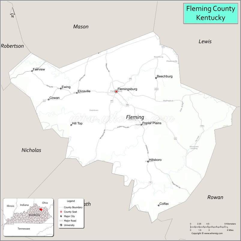
About Fleming County Map, Kentucky: The map showing the county boundary, county seat, major cities, highways, water bodies and neighbouring counties.
More Kentucky Maps & Info
Map of Fleming County, Kentucky
Fleming County is a county located in the U.S. state of Kentucky. It's county seat is Flemingsburg. As per 2020 census, the population of Fleming County is 15224 people and population density is square miles. According to the United States Census Bureau, the county has a total area of 351 sq mi (909 km2). Fleming County was established on 1798.
Fleming County Facts
| Continent | North America |
| Country | United States |
| State | Kentucky |
| County Seat | Flemingsburg |
| Largest City/Town | Flemingsburg |
| Established | 1798 |
| Total Area | 351 sq mi (909 sq km) |
| Land Area | 349 sq mi (904 sq km) |
| Water Area | 1.7 sq mi (4 sq km) |
| Population | 14,390 (Census 2020) |
| Population Density | 41 people per sq mi |
| Time Zone | Eastern Time Zone (ET) |
| Major Highways | Kentucky Route 11, Kentucky Route 32, Kentucky Route 57, U.S. Route 68 |
| Major Rivers | Licking River, Fox Creek |
| Neighboring Counties | Lewis County, Mason County, Nicholas County, Rowan County, Bath County |
| Famous For | Covered bridges, rolling Bluegrass foothills, Amish communities, and rural Kentucky heritage |
| Top Attractions | Ringos Mill Covered Bridge, Fleming County Covered Bridge Museum, Blue Licks Battlefield nearby area, downtown Flemingsburg, scenic countryside drives |
| Official Website | Official Website |
About Fleming County, Kentucky
Fleming County is located in northeastern Kentucky within the Bluegrass foothills region and was established in 1798. The county seat and largest city is Flemingsburg. Fleming County is known for its scenic rolling farmland, historic covered bridges, Amish communities, and strong agricultural traditions. ([en.wikipedia.org](https://en.wikipedia.org/wiki/Fleming_County%2C_Kentucky?utm_source=chatgpt.com))
Cities and Communities in Fleming County, Kentucky
| City/Town | Population | Latitude & Longitude |
|---|---|---|
| Flemingsburg (county seat) | 2,700+ | 38.4223°N, 83.7349°W |
| Ewing | 300+ | 38.4201°N, 83.4535°W |
| Hillsboro | Historic Community | 38.3037°N, 83.6677°W |
| Wallingford | Unincorporated | 38.3706°N, 83.5938°W |
| Ringos Mills | Historic Community | 38.4118°N, 83.7990°W |
| Tilton | Unincorporated | 38.4440°N, 83.6742°W |
| Foxport | Unincorporated | 38.4677°N, 83.6060°W |
| Goddard | Historic Community | 38.3632°N, 83.8082°W |
Best Golf Courses in Fleming County, Kentucky
| Golf Course | Location | Latitude & Longitude |
|---|---|---|
| Fleming County Golf Association Course | Flemingsburg | 38.4109°N, 83.7425°W |
| Lakeview Country Club | Nearby Morehead | 38.1835°N, 83.4618°W |
| Laurel Oaks Golf Club | Nearby Maysville | 38.6532°N, 83.7827°W |
| Eagle Trace Golf Course | Nearby Morehead | 38.1915°N, 83.4378°W |
What are Major Roads and Highways in Fleming County
Major highways connect Fleming County with northeastern Kentucky communities and the Bluegrass region.
- U.S. Route 68 - major east-west highway through Flemingsburg and northeastern Kentucky
- Kentucky Route 11 - important north-south route connecting rural communities
- Kentucky Route 32 - scenic roadway linking Fleming County with Morehead and eastern Kentucky
- Kentucky Route 57 - regional connector serving agricultural and countryside areas
Neighboring Counties of Fleming County
- Lewis County (northeast)
- Mason County (northwest)
- Nicholas County (southwest)
- Rowan County (southeast)
- Bath County (south)
What are Top Attractions in Fleming County, Kentucky
The county features covered bridges, scenic countryside, local history, and outdoor recreation opportunities.
| Main Sight Name | City | Famous For |
|---|---|---|
| Ringos Mill Covered Bridge | Ringos Mills | Historic covered bridge and photography landmark |
| Fleming County Covered Bridge Museum | Flemingsburg | Regional covered bridge history and exhibits |
| Blue Licks Battlefield Nearby Area | Regional Area | Historic Revolutionary War battlefield |
| Downtown Flemingsburg | Flemingsburg | Historic architecture and local shops |
| Scenic Countryside Drives | Countywide | Rolling hills and Bluegrass farmland views |
| Licking River Recreation | Countywide | Fishing, kayaking, and nature scenery |
| Amish Community Areas | Countywide | Traditional farms and handmade crafts |
| Fleming County Courthouse | Flemingsburg | Historic county landmark |
| Fox Creek Recreation Area | Countywide | Outdoor recreation and scenic landscapes |
| Community Heritage Festivals | Flemingsburg Area | Local traditions and Kentucky culture |
Distance from Fleming County to Nearby Cities
The following distances are measured by road (driving).
- Flemingsburg to Maysville, Kentucky - 31 mi (50 km)
- Flemingsburg to Morehead, Kentucky - 36 mi (58 km)
- Flemingsburg to Lexington, Kentucky - 72 mi (116 km)
- Flemingsburg to Cincinnati, Ohio - 77 mi (124 km)
- Flemingsburg to Ashland, Kentucky - 76 mi (122 km)
- Flemingsburg to Huntington, West Virginia - 92 mi (148 km)
- Flemingsburg to Louisville, Kentucky - 138 mi (222 km)
- Flemingsburg to Columbus, Ohio - 151 mi (243 km)
- Flemingsburg to Charleston, West Virginia - 146 mi (235 km)
- Flemingsburg to Indianapolis, Indiana - 216 mi (348 km)
- Flemingsburg to Knoxville, Tennessee - 238 mi (383 km)
- Flemingsburg to Nashville, Tennessee - 298 mi (480 km)
References
- Fleming County Official Website
- Fleming County, Kentucky - Wikipedia
- U.S. Census Bureau QuickFacts
- Kentucky Atlas and Gazetteer
- Regional Tourism Information
- Adair County Map
- Allen County Map
- Anderson County Map
- Ballard County Map
- Barren County Map
- Bath County Map
- Bell County Map
- Boone County Map
- Bourbon County Map
- Boyd County Map
- Boyle County Map
- Bracken County Map
- Breathitt County Map
- Breckinridge County Map
- Bullitt County Map
- Butler County Map
- Caldwell County Map
- Calloway County Map
- Campbell County Map
- Carlisle County Map
- Carroll County Map
- Carter County Map
- Casey County Map
- Christian County Map
- Clark County Map
- Clay County Map
- Clinton County Map
- Crittenden County Map
- Cumberland County Map
- Daviess County Map
- Edmonson County Map
- Elliott County Map
- Estill County Map
- Fayette County Map
- Fleming County Map
- Floyd County Map
- Franklin County Map
- Fulton County Map
- Gallatin County Map
- Garrard County Map
- Grant County Map
- Graves County Map
- Grayson County Map
- Green County Map
- Greenup County Map
- Hancock County Map
- Hardin County Map
- Harlan County Map
- Harrison County Map
- Hart County Map
- Henderson County Map
- Henry County Map
- Hickman County Map
- Hopkins County Map
- Jackson County Map
- Jefferson County Map
- Jessamine County Map
- Johnson County Map
- Kenton County Map
- Knott County Map
- Knox County Map
- LaRue County Map
- Laurel County Map
- Lawrence County Map
- Lee County Map
- Leslie County Map
- Letcher County Map
- Lewis County Map
- Lincoln County Map
- Livingston County Map
- Logan County Map
- Lyon County Map
- McCracken County Map
- McCreary County Map
- McLean County Map
- Madison County Map
- Magoffin County Map
- Marion County Map
- Marshall County Map
- Martin County Map
- Mason County Map
- Meade County Map
- Menifee County Map
- Mercer County Map
- Metcalfe County Map
- Monroe County Map
- Montgomery County Map
- Morgan County Map
- Muhlenberg County Map
- Nelson County Map
- Nicholas County Map
- Ohio County Map
- Oldham County Map
- Owen County Map
- Owsley County Map
- Pendleton County Map
- Perry County Map
- Pike County Map
- Powell County Map
- Pulaski County Map
- Robertson County Map
- Rockcastle County Map
- Rowan County Map
- Russell County Map
- Scott County Map
- Shelby County Map
- Simpson County Map
- Spencer County Map
- Taylor County Map
- Todd County Map
- Trigg County Map
- Trimble County Map
- Union County Map
- Warren County Map
- Washington County Map
- Wayne County Map
- Webster County Map
- Whitley County Map
- Wolfe County Map
- Woodford County Map
- Alabama Counties
- Alaska boroughs
- Arizona Counties
- Arkansas Counties
- California County Map
- Colorado Counties
- Connecticut Counties
- Delaware Counties
- Florida County Map
- Georgia County Map
- Hawaii Counties
- Idaho Counties
- Illinois Counties
- Indiana Counties
- Iowa Counties
- Kansas Counties
- Kentucky Counties
- Louisiana Counties
- Maine Counties
- Maryland Counties
- Massachusetts Counties
- Michigan County Map
- Minnesota Counties
- Mississippi Counties
- Missouri Counties
- Montana Counties
- Nebraska Counties
- Nevada Counties
- New York Counties
- New Hampshire Counties
- New Jersey Counties
- New Mexico Counties
- North Carolina Counties
- North Dakota Counties
- Ohio County Map
- Oklahoma Counties
- Oregon Counties
- Pennsylvania Counties
- Rhode Island Counties
- South Carolina Counties
- South Dakota Counties
- Map of Tennessee
- Texas County Map
- Utah Counties
- Vermont Counties
- Virginia Counties
- Washington Counties
- West Virginia Counties
- Wisconsin Counties
- Wyoming Counties