Map of Livingston County - Livingston County is a county located in the U.S. state of Kentucky. Livingston County Map showing cities, highways, important places and water bodies. Get Where is Livingston County located in the map, major cities in Livingston county, population, areas, and places of interest.
Map of Livingston County, Kentucky
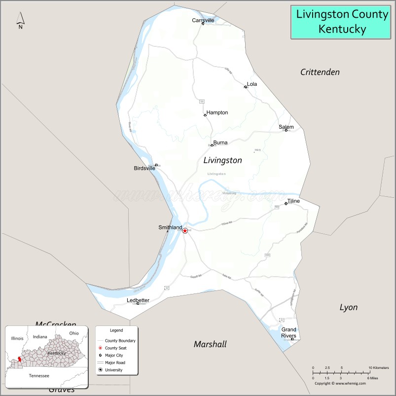
About Livingston County Map, Kentucky: The map showing the county boundary, county seat, major cities, highways, water bodies and neighbouring counties.
More Kentucky Maps & Info
Map of Livingston County, Kentucky
Livingston County is a county located in the U.S. state of Kentucky. It's county seat is Smithland. As per 2020 census, the population of Livingston County is 8959 people and population density is square miles. According to the United States Census Bureau, the county has a total area of 316 sq mi (818 km2). Livingston County was established on 1799.
Livingston County Facts
| Continent | North America |
| Country | United States |
| State | Kentucky |
| County Seat | Smithland |
| Largest City/Town | Ledbetter |
| Established | 1798 |
| Total Area | 342 sq mi (886 sq km) |
| Land Area | 313 sq mi (811 sq km) |
| Water Area | 29 sq mi (75 sq km) |
| Population | 8,888 (Census 2020) |
| Population Density | 28 people per sq mi |
| Time Zone | Central Time Zone (CT) |
| Major Highways | Interstate 24, Interstate 69, U.S. Route 60, U.S. Route 62, Kentucky Route 453 |
| Major Rivers | Ohio River, Cumberland River, Tennessee River |
| Neighboring Counties | Crittenden County, Lyon County, Marshall County, McCracken County, Pope County (IL), Hardin County (IL), Massac County (IL) |
| Famous For | Land Between the Lakes nearby area, river recreation, Kentucky Lake region, and scenic western Kentucky landscapes |
| Top Attractions | Smithland Locks and Dam, Land Between the Lakes nearby area, Patti's 1880's Settlement nearby area, Ohio River recreation, Livingston County Museum |
| Official Website | Official Website |
About Livingston County, Kentucky
Livingston County is located in western Kentucky along the Ohio River and was established in 1798 from Christian County. The county seat is Smithland and the largest community is Ledbetter. Livingston County is known for riverfront scenery, access to the Land Between the Lakes region, outdoor recreation, and its location near Kentucky Lake and Barkley Lake. :contentReference[oaicite:0]{index=0}
Cities and Communities in Livingston County, Kentucky
| City/Town | Population | Latitude & Longitude |
|---|---|---|
| Smithland (county seat) | 300+ | 37.1384°N, 88.4031°W |
| Salem | 700+ | 37.2648°N, 88.2520°W |
| Grand Rivers | 350+ | 37.0037°N, 88.2292°W |
| Ledbetter | 1,600+ | 37.0487°N, 88.4814°W |
| Carrsville | 40+ | 37.3987°N, 88.4987°W |
| Burna | Unincorporated | 37.2436°N, 88.3608°W |
| Hampton | Rural Community | 37.2758°N, 88.3805°W |
| Lola | Historic Community | 37.3165°N, 88.3091°W |
Best Golf Courses in Livingston County, Kentucky
| Golf Course | Location | Latitude & Longitude |
|---|---|---|
| Calvert City Country Club | Nearby Calvert City | 37.0228°N, 88.3382°W |
| Drake Creek Golf Club | Nearby Ledbetter | 37.0415°N, 88.4917°W |
| Kentucky Dam Village Golf Course | Nearby Gilbertsville | 37.0147°N, 88.2708°W |
| Benton Golf & Country Club | Nearby Benton | 36.8870°N, 88.3544°W |
What are Major Roads and Highways in Livingston County
Major highways connect Livingston County with western Kentucky, southern Illinois, and the Tennessee Valley region.
- Interstate 24 - major east-west interstate through western Kentucky
- Interstate 69 - important north-south transportation corridor
- U.S. Route 60 - regional highway linking river communities and western Kentucky towns
- U.S. Route 62 - scenic roadway serving Livingston County and nearby recreation areas
- Kentucky Route 453 - connector route toward Land Between the Lakes
Neighboring Counties of Livingston County
- Crittenden County (northeast)
- Lyon County (southeast)
- Marshall County (south)
- McCracken County (southwest)
- Pope County, Illinois (northwest)
- Hardin County, Illinois (north)
- Massac County, Illinois (west)
What are Top Attractions in Livingston County, Kentucky
The county offers river recreation, scenic lake destinations, historic landmarks, and outdoor adventure opportunities.
| Main Sight Name | City | Famous For |
|---|---|---|
| Smithland Locks and Dam | Smithland | Ohio River engineering and scenic river views |
| Land Between the Lakes Nearby Area | Grand Rivers Area | Camping, hiking, boating, and wildlife viewing |
| Patti's 1880's Settlement Nearby Area | Grand Rivers Area | Dining, shopping, and tourism destination |
| Ohio River Recreation | Countywide | Fishing, boating, and riverside scenery |
| Livingston County Museum | Smithland | Regional history and heritage exhibits |
| Kentucky Lake Scenic Areas | Countywide | Water recreation and photography |
| Grand Rivers Tourism District | Grand Rivers | Resorts, restaurants, and lake access |
| River Heritage Scenic Drives | Countywide | Western Kentucky landscapes and river overlooks |
| Outdoor Recreation Trails | Countywide | Nature hiking and wildlife observation |
| Community Festivals | Countywide | Local culture and seasonal celebrations |
Distance from Livingston County to Nearby Cities
The following distances are measured by road (driving).
- Smithland to Paducah, Kentucky - 23 mi (37 km)
- Smithland to Murray, Kentucky - 55 mi (89 km)
- Smithland to Evansville, Indiana - 102 mi (164 km)
- Smithland to Nashville, Tennessee - 132 mi (212 km)
- Smithland to St. Louis, Missouri - 171 mi (275 km)
- Smithland to Louisville, Kentucky - 225 mi (362 km)
- Smithland to Memphis, Tennessee - 204 mi (328 km)
- Smithland to Indianapolis, Indiana - 238 mi (383 km)
- Smithland to Lexington, Kentucky - 266 mi (428 km)
- Smithland to Chicago, Illinois - 356 mi (573 km)
- Smithland to Cincinnati, Ohio - 319 mi (513 km)
- Smithland to Atlanta, Georgia - 417 mi (671 km)
References
- Livingston County Official Website
- Livingston County, Kentucky - Wikipedia
- U.S. Census Bureau QuickFacts
- Land Between the Lakes National Recreation Area
- Livingston County History
- Adair County Map
- Allen County Map
- Anderson County Map
- Ballard County Map
- Barren County Map
- Bath County Map
- Bell County Map
- Boone County Map
- Bourbon County Map
- Boyd County Map
- Boyle County Map
- Bracken County Map
- Breathitt County Map
- Breckinridge County Map
- Bullitt County Map
- Butler County Map
- Caldwell County Map
- Calloway County Map
- Campbell County Map
- Carlisle County Map
- Carroll County Map
- Carter County Map
- Casey County Map
- Christian County Map
- Clark County Map
- Clay County Map
- Clinton County Map
- Crittenden County Map
- Cumberland County Map
- Daviess County Map
- Edmonson County Map
- Elliott County Map
- Estill County Map
- Fayette County Map
- Fleming County Map
- Floyd County Map
- Franklin County Map
- Fulton County Map
- Gallatin County Map
- Garrard County Map
- Grant County Map
- Graves County Map
- Grayson County Map
- Green County Map
- Greenup County Map
- Hancock County Map
- Hardin County Map
- Harlan County Map
- Harrison County Map
- Hart County Map
- Henderson County Map
- Henry County Map
- Hickman County Map
- Hopkins County Map
- Jackson County Map
- Jefferson County Map
- Jessamine County Map
- Johnson County Map
- Kenton County Map
- Knott County Map
- Knox County Map
- LaRue County Map
- Laurel County Map
- Lawrence County Map
- Lee County Map
- Leslie County Map
- Letcher County Map
- Lewis County Map
- Lincoln County Map
- Livingston County Map
- Logan County Map
- Lyon County Map
- McCracken County Map
- McCreary County Map
- McLean County Map
- Madison County Map
- Magoffin County Map
- Marion County Map
- Marshall County Map
- Martin County Map
- Mason County Map
- Meade County Map
- Menifee County Map
- Mercer County Map
- Metcalfe County Map
- Monroe County Map
- Montgomery County Map
- Morgan County Map
- Muhlenberg County Map
- Nelson County Map
- Nicholas County Map
- Ohio County Map
- Oldham County Map
- Owen County Map
- Owsley County Map
- Pendleton County Map
- Perry County Map
- Pike County Map
- Powell County Map
- Pulaski County Map
- Robertson County Map
- Rockcastle County Map
- Rowan County Map
- Russell County Map
- Scott County Map
- Shelby County Map
- Simpson County Map
- Spencer County Map
- Taylor County Map
- Todd County Map
- Trigg County Map
- Trimble County Map
- Union County Map
- Warren County Map
- Washington County Map
- Wayne County Map
- Webster County Map
- Whitley County Map
- Wolfe County Map
- Woodford County Map
- Alabama Counties
- Alaska boroughs
- Arizona Counties
- Arkansas Counties
- California County Map
- Colorado Counties
- Connecticut Counties
- Delaware Counties
- Florida County Map
- Georgia County Map
- Hawaii Counties
- Idaho Counties
- Illinois Counties
- Indiana Counties
- Iowa Counties
- Kansas Counties
- Kentucky Counties
- Louisiana Counties
- Maine Counties
- Maryland Counties
- Massachusetts Counties
- Michigan County Map
- Minnesota Counties
- Mississippi Counties
- Missouri Counties
- Montana Counties
- Nebraska Counties
- Nevada Counties
- New York Counties
- New Hampshire Counties
- New Jersey Counties
- New Mexico Counties
- North Carolina Counties
- North Dakota Counties
- Ohio County Map
- Oklahoma Counties
- Oregon Counties
- Pennsylvania Counties
- Rhode Island Counties
- South Carolina Counties
- South Dakota Counties
- Map of Tennessee
- Texas County Map
- Utah Counties
- Vermont Counties
- Virginia Counties
- Washington Counties
- West Virginia Counties
- Wisconsin Counties
- Wyoming Counties