Map of Allen County - Allen County is a county located in the U.S. state of Kentucky. Allen County Map showing cities, highways, important places and water bodies. Get Where is Allen County located in the map, major cities in Allen county, population, areas, and places of interest.
Map of Allen County, Kentucky
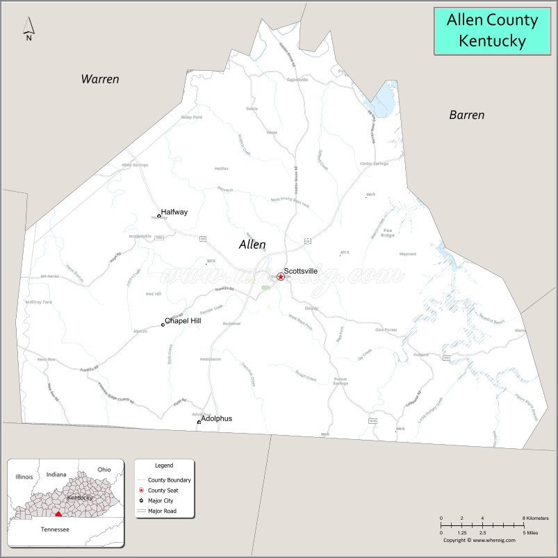
About Allen County Map, Kentucky: The map showing the county boundary, county seat, major cities, highways, water bodies and neighbouring counties.
More Kentucky Maps & Info
Map of Allen County, Kentucky
Allen County is a county located in the U.S. state of Kentucky. It's county seat is Scottsville. As per 2020 census, the population of Allen County is 20797 people and population density is square miles. According to the United States Census Bureau, the county has a total area of 346 sq mi (896 km2). Allen County was established on 1815.
Allen County Facts
| Continent | North America |
| Country | United States |
| State | Kentucky |
| County Seat | Scottsville |
| Largest City/Town | Scottsville |
| Established | 1815 |
| Total Area | 352 sq mi (912 sq km) |
| Land Area | 344 sq mi (891 sq km) |
| Water Area | 7.5 sq mi (19 sq km) |
| Population | 20,588 (Census 2020) |
| Population Density | 59.8 people per sq mi |
| Time Zone | Central Time Zone (CT) |
| Major Highways | U.S. Route 31E, KY Route 100, KY Route 101, KY Route 98 |
| Major Rivers | Barren River, Bays Fork Creek |
| Neighboring Counties | Barren County, Warren County, Simpson County, Monroe County, Macon County (TN), Sumner County (TN) |
| Famous For | Agriculture, rural Kentucky landscapes, Scottsville, and Barren River recreation |
| Top Attractions | Barren River Lake, Scottsville Historic District, Allen County Courthouse, Barren River State Resort Park nearby area, Farmers Markets |
| Official Website | Official Website |
About Allen County, Kentucky
Allen County is located in south-central Kentucky along the Tennessee border and was established in 1815. The county seat and largest city is Scottsville. Allen County is known for its agricultural economy, scenic countryside, outdoor recreation near Barren River Lake, and its connection to the Bowling Green metropolitan region. :contentReference[oaicite:0]{index=0}
Cities and Communities in Allen County, Kentucky
| City/Town | Population | Latitude & Longitude |
|---|---|---|
| Scottsville (county seat) | 4,299+ | 36.7534°N, 86.1900°W |
| Adolphus | Unincorporated | 36.6819°N, 86.2875°W |
| Halfway | Unincorporated | 36.8139°N, 86.1961°W |
| Allen Springs | Unincorporated | 36.7481°N, 86.0674°W |
| Settle | Unincorporated | 36.8467°N, 86.2089°W |
| Amos | Unincorporated | 36.7084°N, 86.1256°W |
| Halcomb | Unincorporated | 36.9117°N, 86.1047°W |
| Austin | Unincorporated | 36.8272°N, 86.0554°W |
Best Golf Courses in Allen County, Kentucky
| Golf Course | Location | Latitude & Longitude |
|---|---|---|
| Scottsville Country Club | Scottsville | 36.7511°N, 86.1842°W |
| Barren River Lake State Resort Park Golf Course | Nearby Lucas | 36.9158°N, 86.0346°W |
| CrossWinds Golf Course | Nearby Bowling Green | 36.9639°N, 86.4374°W |
What are Major Roads and Highways in Allen County
Several highways connect Allen County with nearby Kentucky and Tennessee communities.
- U.S. Route 31E - major north-south route connecting Scottsville with Bowling Green and Gallatin, Tennessee
- KY Route 100 - east-west highway linking Scottsville with Franklin and surrounding counties
- KY Route 101 - regional route serving rural communities and agricultural areas
- KY Route 98 - local route connecting Scottsville with Barren River recreation areas
Neighboring Counties of Allen County
- Barren County (east)
- Warren County (northwest)
- Simpson County (west)
- Monroe County (southeast)
- Macon County, Tennessee (south)
- Sumner County, Tennessee (southwest)
What are Top Attractions in Allen County, Kentucky
The county offers outdoor recreation, historic landmarks, and rural Kentucky scenery.
| Main Sight Name | City | Famous For |
|---|---|---|
| Barren River Lake | Allen County Area | Boating, fishing, camping, and lake recreation |
| Scottsville Historic District | Scottsville | Historic downtown buildings and local shops |
| Allen County Courthouse | Scottsville | Historic county government building |
| Barren River State Resort Park | Nearby Lucas | Golf, marina, hiking, and lakeside lodging |
| Farmers Market of Scottsville | Scottsville | Local produce and Kentucky farm products |
| Bays Fork Creek Area | Countywide | Fishing and rural outdoor scenery |
| Old Jail Museum | Scottsville | Local history exhibits and preserved architecture |
| Allen County War Memorial | Scottsville | Veterans memorial and civic landmark |
| White Plains Community Area | Allen County | Historic rural landscapes and farming heritage |
| South Central Kentucky Countryside | Countywide | Scenic drives and agricultural landscapes |
Distance from Allen County to Nearby Cities
The following distances are measured by road (driving).
- Scottsville to Bowling Green, Kentucky - 24 mi (39 km)
- Scottsville to Nashville, Tennessee - 62 mi (100 km)
- Scottsville to Franklin, Kentucky - 26 mi (42 km)
- Scottsville to Glasgow, Kentucky - 32 mi (51 km)
- Scottsville to Gallatin, Tennessee - 36 mi (58 km)
- Scottsville to Louisville, Kentucky - 131 mi (211 km)
- Scottsville to Lexington, Kentucky - 139 mi (224 km)
- Scottsville to Russellville, Kentucky - 48 mi (77 km)
- Scottsville to Columbia, Kentucky - 53 mi (85 km)
- Scottsville to Cookeville, Tennessee - 83 mi (134 km)
- Scottsville to Elizabethtown, Kentucky - 88 mi (142 km)
- Scottsville to Clarksville, Tennessee - 73 mi (117 km)
References
- U.S. Census Bureau QuickFacts
- Allen County, Kentucky - Wikipedia
- Allen County Official Website
- Kentucky Atlas and Gazetteer
- World Population Review
- Adair County Map
- Allen County Map
- Anderson County Map
- Ballard County Map
- Barren County Map
- Bath County Map
- Bell County Map
- Boone County Map
- Bourbon County Map
- Boyd County Map
- Boyle County Map
- Bracken County Map
- Breathitt County Map
- Breckinridge County Map
- Bullitt County Map
- Butler County Map
- Caldwell County Map
- Calloway County Map
- Campbell County Map
- Carlisle County Map
- Carroll County Map
- Carter County Map
- Casey County Map
- Christian County Map
- Clark County Map
- Clay County Map
- Clinton County Map
- Crittenden County Map
- Cumberland County Map
- Daviess County Map
- Edmonson County Map
- Elliott County Map
- Estill County Map
- Fayette County Map
- Fleming County Map
- Floyd County Map
- Franklin County Map
- Fulton County Map
- Gallatin County Map
- Garrard County Map
- Grant County Map
- Graves County Map
- Grayson County Map
- Green County Map
- Greenup County Map
- Hancock County Map
- Hardin County Map
- Harlan County Map
- Harrison County Map
- Hart County Map
- Henderson County Map
- Henry County Map
- Hickman County Map
- Hopkins County Map
- Jackson County Map
- Jefferson County Map
- Jessamine County Map
- Johnson County Map
- Kenton County Map
- Knott County Map
- Knox County Map
- LaRue County Map
- Laurel County Map
- Lawrence County Map
- Lee County Map
- Leslie County Map
- Letcher County Map
- Lewis County Map
- Lincoln County Map
- Livingston County Map
- Logan County Map
- Lyon County Map
- McCracken County Map
- McCreary County Map
- McLean County Map
- Madison County Map
- Magoffin County Map
- Marion County Map
- Marshall County Map
- Martin County Map
- Mason County Map
- Meade County Map
- Menifee County Map
- Mercer County Map
- Metcalfe County Map
- Monroe County Map
- Montgomery County Map
- Morgan County Map
- Muhlenberg County Map
- Nelson County Map
- Nicholas County Map
- Ohio County Map
- Oldham County Map
- Owen County Map
- Owsley County Map
- Pendleton County Map
- Perry County Map
- Pike County Map
- Powell County Map
- Pulaski County Map
- Robertson County Map
- Rockcastle County Map
- Rowan County Map
- Russell County Map
- Scott County Map
- Shelby County Map
- Simpson County Map
- Spencer County Map
- Taylor County Map
- Todd County Map
- Trigg County Map
- Trimble County Map
- Union County Map
- Warren County Map
- Washington County Map
- Wayne County Map
- Webster County Map
- Whitley County Map
- Wolfe County Map
- Woodford County Map
- Alabama Counties
- Alaska boroughs
- Arizona Counties
- Arkansas Counties
- California County Map
- Colorado Counties
- Connecticut Counties
- Delaware Counties
- Florida County Map
- Georgia County Map
- Hawaii Counties
- Idaho Counties
- Illinois Counties
- Indiana Counties
- Iowa Counties
- Kansas Counties
- Kentucky Counties
- Louisiana Counties
- Maine Counties
- Maryland Counties
- Massachusetts Counties
- Michigan County Map
- Minnesota Counties
- Mississippi Counties
- Missouri Counties
- Montana Counties
- Nebraska Counties
- Nevada Counties
- New York Counties
- New Hampshire Counties
- New Jersey Counties
- New Mexico Counties
- North Carolina Counties
- North Dakota Counties
- Ohio County Map
- Oklahoma Counties
- Oregon Counties
- Pennsylvania Counties
- Rhode Island Counties
- South Carolina Counties
- South Dakota Counties
- Map of Tennessee
- Texas County Map
- Utah Counties
- Vermont Counties
- Virginia Counties
- Washington Counties
- West Virginia Counties
- Wisconsin Counties
- Wyoming Counties