Map of Clark County - Clark County is a county located in the U.S. state of Kentucky. Clark County Map showing cities, highways, important places and water bodies. Get Where is Clark County located in the map, major cities in Clark county, population, areas, and places of interest.
Map of Clark County, Kentucky
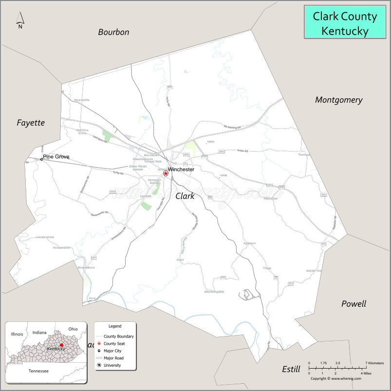
About Clark County Map, Kentucky: The map showing the county boundary, county seat, major cities, highways, water bodies and neighbouring counties.
More Kentucky Maps & Info
Map of Clark County, Kentucky
Clark County is a county located in the U.S. state of Kentucky. It's county seat is Winchester. As per 2020 census, the population of Clark County is 36871 people and population density is square miles. According to the United States Census Bureau, the county has a total area of 254 sq mi (658 km2). Clark County was established on 1792.
Clark County Facts
| Continent | North America |
| Country | United States |
| State | Kentucky |
| County Seat | Winchester |
| Largest City/Town | Winchester |
| Established | 1792 |
| Total Area | 255 sq mi (660 sq km) |
| Land Area | 252 sq mi (653 sq km) |
| Water Area | 2.7 sq mi (7 sq km) |
| Population | 36,972 (Census 2020) |
| Population Density | 147 people per sq mi |
| Time Zone | Eastern Time Zone (ET) |
| Major Highways | Interstate 64, U.S. Route 60, Kentucky Route 15, Kentucky Route 627 |
| Major Rivers | Kentucky River nearby area, Red River nearby area, Lulbegrud Creek |
| Neighboring Counties | Montgomery County, Bourbon County, Madison County, Fayette County, Powell County, Estill County |
| Famous For | Ale-8-One soft drink, horse farms, Bluegrass landscapes, and Winchester history |
| Top Attractions | Bluegrass Heritage Museum, Fort Boonesborough nearby area, Lower Howard's Creek Nature Preserve, Ale-8-One plant, downtown Winchester |
| Official Website | Official Website |
About Clark County, Kentucky
Clark County is located in the Bluegrass region of central Kentucky and was established in 1792 as one of Kentucky’s original counties. The county seat and largest city is Winchester. Clark County is known for its horse farms, rolling Bluegrass scenery, historic sites, and as the home of the famous Ale-8-One soft drink. ([en.wikipedia.org](https://en.wikipedia.org/wiki/Clark_County%2C_Kentucky?utm_source=chatgpt.com))
Cities and Communities in Clark County, Kentucky
| City/Town | Population | Latitude & Longitude |
|---|---|---|
| Winchester (county seat) | 19,000+ | 37.9901°N, 84.1797°W |
| Clay City Nearby Area | Regional Community | 37.8598°N, 83.9305°W |
| Ford | Unincorporated | 38.0209°N, 84.1233°W |
| Hedges | Unincorporated | 37.9612°N, 84.0895°W |
| Trapp | Historic Community | 37.8665°N, 84.1198°W |
| Combs Ferry | Historic Community | 37.9064°N, 84.0735°W |
| Pilot View | Unincorporated | 38.0547°N, 84.2435°W |
| Indian Fields | Historic Community | 37.9555°N, 84.1537°W |
Best Golf Courses in Clark County, Kentucky
| Golf Course | Location | Latitude & Longitude |
|---|---|---|
| Cassell Creek Golf Course | Winchester | 37.9878°N, 84.1561°W |
| Winchester Country Club | Winchester | 37.9825°N, 84.1902°W |
| University Club of Kentucky Nearby Area | Lexington Area | 38.0407°N, 84.4183°W |
| Gibson Bay Golf Course Nearby Area | Richmond Area | 37.7660°N, 84.3018°W |
What are Major Roads and Highways in Clark County
Major highways connect Clark County with Lexington, eastern Kentucky, and regional Bluegrass communities.
- Interstate 64 - major east-west interstate connecting Winchester with Lexington and eastern Kentucky
- U.S. Route 60 - regional highway through Winchester and surrounding communities
- Kentucky Route 15 - important route connecting central Kentucky with the Appalachian region
- Kentucky Route 627 - scenic connector through rural Bluegrass countryside
Neighboring Counties of Clark County
- Montgomery County (east)
- Bourbon County (north)
- Madison County (south)
- Fayette County (west)
- Powell County (southeast)
- Estill County (south)
What are Top Attractions in Clark County, Kentucky
The county offers historic landmarks, nature preserves, horse country scenery, and family attractions.
| Main Sight Name | City | Famous For |
|---|---|---|
| Bluegrass Heritage Museum | Winchester | Regional history and cultural exhibits |
| Fort Boonesborough Nearby Area | Regional Area | Historic pioneer fort and living history demonstrations |
| Lower Howard's Creek Nature Preserve | Clark County | Scenic limestone gorge and hiking trails |
| Ale-8-One Plant | Winchester | Historic Kentucky soft drink production |
| Downtown Winchester | Winchester | Historic architecture, restaurants, and shopping |
| Bluegrass Scenic Horse Farms | Countywide | Horse breeding farms and countryside views |
| Combs Ferry Historic Area | Combs Ferry | Historic ferry crossing and Kentucky River heritage |
| Clark County Fairgrounds | Winchester | Community fairs and agricultural events |
| Lulbegrud Creek Area | Countywide | Nature scenery and fishing spots |
| Civil War Heritage Sites | Countywide | Historical markers and regional history |
Distance from Clark County to Nearby Cities
The following distances are measured by road (driving).
- Winchester to Lexington, Kentucky - 18 mi (29 km)
- Winchester to Richmond, Kentucky - 29 mi (47 km)
- Winchester to Frankfort, Kentucky - 47 mi (76 km)
- Winchester to Louisville, Kentucky - 94 mi (151 km)
- Winchester to Morehead, Kentucky - 63 mi (101 km)
- Winchester to Cincinnati, Ohio - 92 mi (148 km)
- Winchester to Huntington, West Virginia - 128 mi (206 km)
- Winchester to Knoxville, Tennessee - 172 mi (277 km)
- Winchester to Columbus, Ohio - 175 mi (282 km)
- Winchester to Nashville, Tennessee - 229 mi (369 km)
- Winchester to Indianapolis, Indiana - 191 mi (307 km)
- Winchester to Charleston, West Virginia - 158 mi (254 km)
References
- Clark County Official Website
- Clark County, Kentucky - Wikipedia
- U.S. Census Bureau QuickFacts
- Fort Boonesborough State Park
- Kentucky Atlas and Gazetteer
- Adair County Map
- Allen County Map
- Anderson County Map
- Ballard County Map
- Barren County Map
- Bath County Map
- Bell County Map
- Boone County Map
- Bourbon County Map
- Boyd County Map
- Boyle County Map
- Bracken County Map
- Breathitt County Map
- Breckinridge County Map
- Bullitt County Map
- Butler County Map
- Caldwell County Map
- Calloway County Map
- Campbell County Map
- Carlisle County Map
- Carroll County Map
- Carter County Map
- Casey County Map
- Christian County Map
- Clark County Map
- Clay County Map
- Clinton County Map
- Crittenden County Map
- Cumberland County Map
- Daviess County Map
- Edmonson County Map
- Elliott County Map
- Estill County Map
- Fayette County Map
- Fleming County Map
- Floyd County Map
- Franklin County Map
- Fulton County Map
- Gallatin County Map
- Garrard County Map
- Grant County Map
- Graves County Map
- Grayson County Map
- Green County Map
- Greenup County Map
- Hancock County Map
- Hardin County Map
- Harlan County Map
- Harrison County Map
- Hart County Map
- Henderson County Map
- Henry County Map
- Hickman County Map
- Hopkins County Map
- Jackson County Map
- Jefferson County Map
- Jessamine County Map
- Johnson County Map
- Kenton County Map
- Knott County Map
- Knox County Map
- LaRue County Map
- Laurel County Map
- Lawrence County Map
- Lee County Map
- Leslie County Map
- Letcher County Map
- Lewis County Map
- Lincoln County Map
- Livingston County Map
- Logan County Map
- Lyon County Map
- McCracken County Map
- McCreary County Map
- McLean County Map
- Madison County Map
- Magoffin County Map
- Marion County Map
- Marshall County Map
- Martin County Map
- Mason County Map
- Meade County Map
- Menifee County Map
- Mercer County Map
- Metcalfe County Map
- Monroe County Map
- Montgomery County Map
- Morgan County Map
- Muhlenberg County Map
- Nelson County Map
- Nicholas County Map
- Ohio County Map
- Oldham County Map
- Owen County Map
- Owsley County Map
- Pendleton County Map
- Perry County Map
- Pike County Map
- Powell County Map
- Pulaski County Map
- Robertson County Map
- Rockcastle County Map
- Rowan County Map
- Russell County Map
- Scott County Map
- Shelby County Map
- Simpson County Map
- Spencer County Map
- Taylor County Map
- Todd County Map
- Trigg County Map
- Trimble County Map
- Union County Map
- Warren County Map
- Washington County Map
- Wayne County Map
- Webster County Map
- Whitley County Map
- Wolfe County Map
- Woodford County Map
- Alabama Counties
- Alaska boroughs
- Arizona Counties
- Arkansas Counties
- California County Map
- Colorado Counties
- Connecticut Counties
- Delaware Counties
- Florida County Map
- Georgia County Map
- Hawaii Counties
- Idaho Counties
- Illinois Counties
- Indiana Counties
- Iowa Counties
- Kansas Counties
- Kentucky Counties
- Louisiana Counties
- Maine Counties
- Maryland Counties
- Massachusetts Counties
- Michigan County Map
- Minnesota Counties
- Mississippi Counties
- Missouri Counties
- Montana Counties
- Nebraska Counties
- Nevada Counties
- New York Counties
- New Hampshire Counties
- New Jersey Counties
- New Mexico Counties
- North Carolina Counties
- North Dakota Counties
- Ohio County Map
- Oklahoma Counties
- Oregon Counties
- Pennsylvania Counties
- Rhode Island Counties
- South Carolina Counties
- South Dakota Counties
- Map of Tennessee
- Texas County Map
- Utah Counties
- Vermont Counties
- Virginia Counties
- Washington Counties
- West Virginia Counties
- Wisconsin Counties
- Wyoming Counties