Map of Henry County - Henry County is a county located in the U.S. state of Kentucky. Henry County Map showing cities, highways, important places and water bodies. Get Where is Henry County located in the map, major cities in Henry county, population, areas, and places of interest.
Map of Henry County, Kentucky
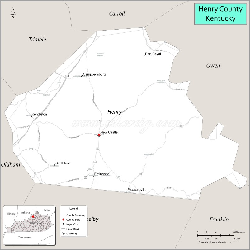
About Henry County Map, Kentucky: The map showing the county boundary, county seat, major cities, highways, water bodies and neighbouring counties.
More Kentucky Maps & Info
Map of Henry County, Kentucky
Henry County is a county located in the U.S. state of Kentucky. It's county seat is New Castle. As per 2020 census, the population of Henry County is 15657 people and population density is square miles. According to the United States Census Bureau, the county has a total area of 289 sq mi (749 km2). Henry County was established on 1798.
Henry County Facts
| Continent | North America |
| Country | United States |
| State | Kentucky |
| County Seat | New Castle |
| Largest City/Town | Eminence |
| Established | 1798 |
| Total Area | 291 sq mi (754 sq km) |
| Land Area | 286 sq mi (741 sq km) |
| Water Area | 5.2 sq mi (13 sq km) |
| Population | 15,678 (Census 2020) |
| Population Density | 55 people per sq mi |
| Time Zone | Eastern Time Zone (ET) |
| Major Highways | Interstate 71, U.S. Route 421, Kentucky Route 55, Kentucky Route 146 |
| Major Rivers | Kentucky River nearby area, Six Mile Creek |
| Neighboring Counties | Oldham County, Shelby County, Trimble County, Carroll County, Franklin County, Owen County |
| Famous For | Kentucky horse farms, historic small towns, agriculture, and Bluegrass countryside |
| Top Attractions | Eminence Historic District, Kentucky Renaissance Faire nearby area, Harry Hill Park, New Castle Historic Courthouse, Bluegrass scenic drives |
| Official Website | Official Website |
About Henry County, Kentucky
Henry County is located in north-central Kentucky within the Bluegrass region and was established in 1798. The county seat is New Castle, while Eminence is the largest city. Henry County is known for its scenic horse farms, rolling farmland, historic communities, and rural Kentucky heritage near the Louisville metropolitan region. ([en.wikipedia.org](https://en.wikipedia.org/wiki/Henry_County%2C_Kentucky?utm_source=chatgpt.com))
Cities and Communities in Henry County, Kentucky
| City/Town | Population | Latitude & Longitude |
|---|---|---|
| Eminence | 2,500+ | 38.3706°N, 85.1805°W |
| New Castle (county seat) | 900+ | 38.4337°N, 85.1691°W |
| Campbellsburg | 800+ | 38.5234°N, 85.2063°W |
| Pleasureville | 700+ | 38.3867°N, 85.0555°W |
| Smithfield | 100+ | 38.3935°N, 85.2571°W |
| Sulphur | Unincorporated | 38.4812°N, 85.2179°W |
| Lockport | Historic Community | 38.4445°N, 84.9631°W |
| Turners Station | Rural Community | 38.4682°N, 85.0895°W |
Best Golf Courses in Henry County, Kentucky
| Golf Course | Location | Latitude & Longitude |
|---|---|---|
| Eminence Country Club | Eminence | 38.3651°N, 85.1794°W |
| Weissinger Hills Golf Course | Nearby Shelbyville | 38.2234°N, 85.2615°W |
| Oldham County Country Club | Nearby La Grange | 38.4252°N, 85.3770°W |
| Nevel Meade Golf Course | Nearby Prospect | 38.3740°N, 85.5751°W |
What are Major Roads and Highways in Henry County
Major highways connect Henry County with Louisville, Lexington, and northern Kentucky communities.
- Interstate 71 - major interstate corridor linking Louisville and Cincinnati
- U.S. Route 421 - regional north-south highway through Henry County communities
- Kentucky Route 55 - important route connecting Eminence with neighboring counties
- Kentucky Route 146 - scenic roadway serving rural farmland and historic towns
Neighboring Counties of Henry County
- Oldham County (west)
- Shelby County (south)
- Trimble County (north)
- Carroll County (northwest)
- Franklin County (east)
- Owen County (northeast)
What are Top Attractions in Henry County, Kentucky
The county offers horse farm scenery, historic districts, parks, and Bluegrass countryside attractions.
| Main Sight Name | City | Famous For |
|---|---|---|
| Eminence Historic District | Eminence | Historic downtown architecture and local shops |
| Kentucky Renaissance Faire Nearby Area | Eminence Area | Annual medieval festival and entertainment |
| Harry Hill Park | Eminence | Sports facilities and community recreation |
| New Castle Historic Courthouse | New Castle | Historic county landmark and architecture |
| Bluegrass Scenic Drives | Countywide | Horse farms and rolling countryside landscapes |
| Campbellsburg Historic Area | Campbellsburg | Small-town heritage and local culture |
| Pleasureville Historic District | Pleasureville | Historic homes and rural Kentucky charm |
| Local Horse Farms | Countywide | Equestrian culture and farm tours |
| Outdoor Recreation Areas | Countywide | Fishing, hiking, and countryside recreation |
| Community Festivals | Countywide | Seasonal events and local traditions |
Distance from Henry County to Nearby Cities
The following distances are measured by road (driving).
- Eminence to Louisville, Kentucky - 39 mi (63 km)
- New Castle to Frankfort, Kentucky - 35 mi (56 km)
- Eminence to Lexington, Kentucky - 63 mi (101 km)
- Campbellsburg to Cincinnati, Ohio - 86 mi (138 km)
- Eminence to Shelbyville, Kentucky - 22 mi (35 km)
- New Castle to La Grange, Kentucky - 25 mi (40 km)
- Eminence to Indianapolis, Indiana - 120 mi (193 km)
- Campbellsburg to Nashville, Tennessee - 184 mi (296 km)
- New Castle to Columbus, Ohio - 173 mi (278 km)
- Eminence to Knoxville, Tennessee - 223 mi (359 km)
- Campbellsburg to Chicago, Illinois - 301 mi (484 km)
- New Castle to St. Louis, Missouri - 307 mi (494 km)
References
- Henry County Official Website
- Henry County, Kentucky - Wikipedia
- U.S. Census Bureau QuickFacts
- Kentucky Renaissance Faire
- Kentucky Tourism
- Adair County Map
- Allen County Map
- Anderson County Map
- Ballard County Map
- Barren County Map
- Bath County Map
- Bell County Map
- Boone County Map
- Bourbon County Map
- Boyd County Map
- Boyle County Map
- Bracken County Map
- Breathitt County Map
- Breckinridge County Map
- Bullitt County Map
- Butler County Map
- Caldwell County Map
- Calloway County Map
- Campbell County Map
- Carlisle County Map
- Carroll County Map
- Carter County Map
- Casey County Map
- Christian County Map
- Clark County Map
- Clay County Map
- Clinton County Map
- Crittenden County Map
- Cumberland County Map
- Daviess County Map
- Edmonson County Map
- Elliott County Map
- Estill County Map
- Fayette County Map
- Fleming County Map
- Floyd County Map
- Franklin County Map
- Fulton County Map
- Gallatin County Map
- Garrard County Map
- Grant County Map
- Graves County Map
- Grayson County Map
- Green County Map
- Greenup County Map
- Hancock County Map
- Hardin County Map
- Harlan County Map
- Harrison County Map
- Hart County Map
- Henderson County Map
- Henry County Map
- Hickman County Map
- Hopkins County Map
- Jackson County Map
- Jefferson County Map
- Jessamine County Map
- Johnson County Map
- Kenton County Map
- Knott County Map
- Knox County Map
- LaRue County Map
- Laurel County Map
- Lawrence County Map
- Lee County Map
- Leslie County Map
- Letcher County Map
- Lewis County Map
- Lincoln County Map
- Livingston County Map
- Logan County Map
- Lyon County Map
- McCracken County Map
- McCreary County Map
- McLean County Map
- Madison County Map
- Magoffin County Map
- Marion County Map
- Marshall County Map
- Martin County Map
- Mason County Map
- Meade County Map
- Menifee County Map
- Mercer County Map
- Metcalfe County Map
- Monroe County Map
- Montgomery County Map
- Morgan County Map
- Muhlenberg County Map
- Nelson County Map
- Nicholas County Map
- Ohio County Map
- Oldham County Map
- Owen County Map
- Owsley County Map
- Pendleton County Map
- Perry County Map
- Pike County Map
- Powell County Map
- Pulaski County Map
- Robertson County Map
- Rockcastle County Map
- Rowan County Map
- Russell County Map
- Scott County Map
- Shelby County Map
- Simpson County Map
- Spencer County Map
- Taylor County Map
- Todd County Map
- Trigg County Map
- Trimble County Map
- Union County Map
- Warren County Map
- Washington County Map
- Wayne County Map
- Webster County Map
- Whitley County Map
- Wolfe County Map
- Woodford County Map
- Alabama Counties
- Alaska boroughs
- Arizona Counties
- Arkansas Counties
- California County Map
- Colorado Counties
- Connecticut Counties
- Delaware Counties
- Florida County Map
- Georgia County Map
- Hawaii Counties
- Idaho Counties
- Illinois Counties
- Indiana Counties
- Iowa Counties
- Kansas Counties
- Kentucky Counties
- Louisiana Counties
- Maine Counties
- Maryland Counties
- Massachusetts Counties
- Michigan County Map
- Minnesota Counties
- Mississippi Counties
- Missouri Counties
- Montana Counties
- Nebraska Counties
- Nevada Counties
- New York Counties
- New Hampshire Counties
- New Jersey Counties
- New Mexico Counties
- North Carolina Counties
- North Dakota Counties
- Ohio County Map
- Oklahoma Counties
- Oregon Counties
- Pennsylvania Counties
- Rhode Island Counties
- South Carolina Counties
- South Dakota Counties
- Map of Tennessee
- Texas County Map
- Utah Counties
- Vermont Counties
- Virginia Counties
- Washington Counties
- West Virginia Counties
- Wisconsin Counties
- Wyoming Counties