Map of Lincoln County - Lincoln County is a county located in the U.S. state of Kentucky. Lincoln County Map showing cities, highways, important places and water bodies. Get Where is Lincoln County located in the map, major cities in Lincoln county, population, areas, and places of interest.
Map of Lincoln County, Kentucky
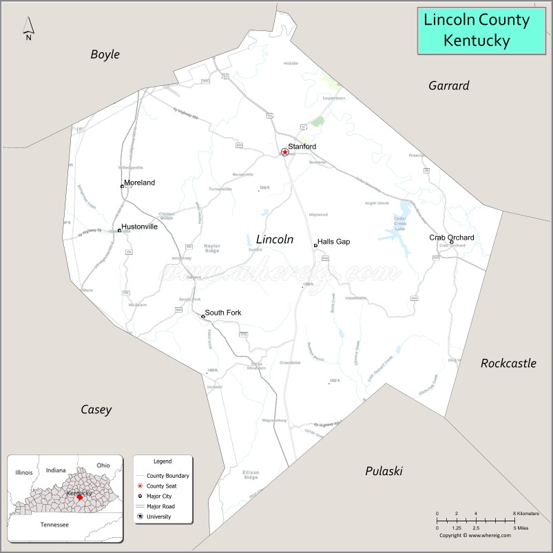
About Lincoln County Map, Kentucky: The map showing the county boundary, county seat, major cities, highways, water bodies and neighbouring counties.
More Kentucky Maps & Info
Map of Lincoln County, Kentucky
Lincoln County is a county located in the U.S. state of Kentucky. It's county seat is Stanford. As per 2020 census, the population of Lincoln County is 24243 people and population density is square miles. According to the United States Census Bureau, the county has a total area of 337 sq mi (873 km2). Lincoln County was established on 1780.
Lincoln County Facts
| Continent | North America |
| Country | United States |
| State | Kentucky |
| County Seat | Stanford |
| Largest City/Town | Stanford |
| Established | 1780 |
| Total Area | 337 sq mi (873 sq km) |
| Land Area | 334 sq mi (865 sq km) |
| Water Area | 2.5 sq mi (6 sq km) |
| Population | 24,275 (Census 2020) |
| Population Density | 73 people per sq mi |
| Time Zone | Eastern Time Zone (ET) |
| Major Highways | U.S. Route 27, U.S. Route 150, Kentucky Route 78, Kentucky Route 1247 |
| Major Rivers | Green River, Dix River |
| Neighboring Counties | Boyle County, Garrard County, Casey County, Pulaski County, Rockcastle County, Mercer County |
| Famous For | Historic Kentucky settlements, Stanford historic district, rolling farmland, and early frontier heritage |
| Top Attractions | William Whitley House State Historic Site, Stanford Historic District, Cedar Creek Lake nearby area, Lincoln County Courthouse, Kentucky Wilderness Trail |
| Official Website | Official Website |
About Lincoln County, Kentucky
Lincoln County is located in south-central Kentucky and was established in 1780 as one of the original Kentucky counties formed from Virginia territory. The county seat and largest city is Stanford, one of Kentucky’s oldest settlements. Lincoln County is known for its frontier history, scenic farmland, historic architecture, and early role in Kentucky settlement and development. :contentReference[oaicite:0]{index=0}
Cities and Communities in Lincoln County, Kentucky
| City/Town | Population | Latitude & Longitude |
|---|---|---|
| Stanford (county seat) | 3,700+ | 37.5312°N, 84.6616°W |
| Crab Orchard | 800+ | 37.4731°N, 84.5074°W |
| Hustonville | 500+ | 37.4795°N, 84.8174°W |
| Waynesburg | 1,000+ | 37.3643°N, 84.6610°W |
| McKinney | Rural Community | 37.5518°N, 84.7605°W |
| Kings Mountain | Historic Community | 37.3360°N, 84.7658°W |
| Highland | Unincorporated | 37.6102°N, 84.6247°W |
| Rowland | Rural Community | 37.4190°N, 84.5888°W |
Best Golf Courses in Lincoln County, Kentucky
| Golf Course | Location | Latitude & Longitude |
|---|---|---|
| Bright Leaf Golf Resort | Harrodsburg Area | 37.7425°N, 84.8172°W |
| Danville Country Club | Nearby Danville | 37.6406°N, 84.7959°W |
| Gibson Bay Golf Course | Nearby Richmond | 37.7660°N, 84.3018°W |
| Lincoln County Country Club | Stanford Area | 37.5367°N, 84.6754°W |
What are Major Roads and Highways in Lincoln County
Major highways connect Lincoln County with central Kentucky, Appalachian foothill communities, and regional transportation corridors.
- U.S. Route 27 - major north-south corridor through Stanford and central Kentucky
- U.S. Route 150 - important east-west route linking Danville and surrounding communities
- Kentucky Route 78 - regional roadway serving rural communities and farmland
- Kentucky Route 1247 - connector highway through southern Lincoln County
Neighboring Counties of Lincoln County
- Boyle County (north)
- Garrard County (northeast)
- Casey County (southwest)
- Pulaski County (south)
- Rockcastle County (southeast)
- Mercer County (northwest)
What are Top Attractions in Lincoln County, Kentucky
The county offers historic landmarks, scenic countryside, outdoor recreation, and early Kentucky frontier attractions.
| Main Sight Name | City | Famous For |
|---|---|---|
| William Whitley House State Historic Site | Stanford Area | Historic frontier mansion and early Kentucky history |
| Stanford Historic District | Stanford | Historic downtown architecture and heritage |
| Cedar Creek Lake Nearby Area | Regional Area | Fishing, boating, and outdoor recreation |
| Lincoln County Courthouse | Stanford | Historic courthouse and civic landmark |
| Kentucky Wilderness Trail | Countywide | Historic pioneer travel route |
| Crab Orchard Springs Area | Crab Orchard | Historic resort heritage and scenic countryside |
| Green River Scenic Areas | Countywide | Fishing and river landscapes |
| Historic Stanford Main Street | Stanford | Local shops and preserved historic buildings |
| Rural Scenic Drives | Countywide | Rolling farmland and Bluegrass scenery |
| Community Heritage Festivals | Countywide | Local culture and seasonal celebrations |
Distance from Lincoln County to Nearby Cities
The following distances are measured by road (driving).
- Stanford to Danville, Kentucky - 11 mi (18 km)
- Stanford to Lexington, Kentucky - 47 mi (76 km)
- Stanford to Richmond, Kentucky - 39 mi (63 km)
- Stanford to Louisville, Kentucky - 92 mi (148 km)
- Stanford to Knoxville, Tennessee - 152 mi (245 km)
- Stanford to Cincinnati, Ohio - 127 mi (204 km)
- Stanford to Nashville, Tennessee - 190 mi (306 km)
- Stanford to Columbus, Ohio - 202 mi (325 km)
- Stanford to Indianapolis, Indiana - 194 mi (312 km)
- Stanford to Charleston, West Virginia - 187 mi (301 km)
- Stanford to Atlanta, Georgia - 339 mi (546 km)
- Stanford to Chicago, Illinois - 356 mi (573 km)
References
- Lincoln County Official Website
- Lincoln County, Kentucky - Wikipedia
- U.S. Census Bureau QuickFacts
- William Whitley House State Historic Site
- Kentucky Atlas - Lincoln County
- Adair County Map
- Allen County Map
- Anderson County Map
- Ballard County Map
- Barren County Map
- Bath County Map
- Bell County Map
- Boone County Map
- Bourbon County Map
- Boyd County Map
- Boyle County Map
- Bracken County Map
- Breathitt County Map
- Breckinridge County Map
- Bullitt County Map
- Butler County Map
- Caldwell County Map
- Calloway County Map
- Campbell County Map
- Carlisle County Map
- Carroll County Map
- Carter County Map
- Casey County Map
- Christian County Map
- Clark County Map
- Clay County Map
- Clinton County Map
- Crittenden County Map
- Cumberland County Map
- Daviess County Map
- Edmonson County Map
- Elliott County Map
- Estill County Map
- Fayette County Map
- Fleming County Map
- Floyd County Map
- Franklin County Map
- Fulton County Map
- Gallatin County Map
- Garrard County Map
- Grant County Map
- Graves County Map
- Grayson County Map
- Green County Map
- Greenup County Map
- Hancock County Map
- Hardin County Map
- Harlan County Map
- Harrison County Map
- Hart County Map
- Henderson County Map
- Henry County Map
- Hickman County Map
- Hopkins County Map
- Jackson County Map
- Jefferson County Map
- Jessamine County Map
- Johnson County Map
- Kenton County Map
- Knott County Map
- Knox County Map
- LaRue County Map
- Laurel County Map
- Lawrence County Map
- Lee County Map
- Leslie County Map
- Letcher County Map
- Lewis County Map
- Lincoln County Map
- Livingston County Map
- Logan County Map
- Lyon County Map
- McCracken County Map
- McCreary County Map
- McLean County Map
- Madison County Map
- Magoffin County Map
- Marion County Map
- Marshall County Map
- Martin County Map
- Mason County Map
- Meade County Map
- Menifee County Map
- Mercer County Map
- Metcalfe County Map
- Monroe County Map
- Montgomery County Map
- Morgan County Map
- Muhlenberg County Map
- Nelson County Map
- Nicholas County Map
- Ohio County Map
- Oldham County Map
- Owen County Map
- Owsley County Map
- Pendleton County Map
- Perry County Map
- Pike County Map
- Powell County Map
- Pulaski County Map
- Robertson County Map
- Rockcastle County Map
- Rowan County Map
- Russell County Map
- Scott County Map
- Shelby County Map
- Simpson County Map
- Spencer County Map
- Taylor County Map
- Todd County Map
- Trigg County Map
- Trimble County Map
- Union County Map
- Warren County Map
- Washington County Map
- Wayne County Map
- Webster County Map
- Whitley County Map
- Wolfe County Map
- Woodford County Map
- Alabama Counties
- Alaska boroughs
- Arizona Counties
- Arkansas Counties
- California County Map
- Colorado Counties
- Connecticut Counties
- Delaware Counties
- Florida County Map
- Georgia County Map
- Hawaii Counties
- Idaho Counties
- Illinois Counties
- Indiana Counties
- Iowa Counties
- Kansas Counties
- Kentucky Counties
- Louisiana Counties
- Maine Counties
- Maryland Counties
- Massachusetts Counties
- Michigan County Map
- Minnesota Counties
- Mississippi Counties
- Missouri Counties
- Montana Counties
- Nebraska Counties
- Nevada Counties
- New York Counties
- New Hampshire Counties
- New Jersey Counties
- New Mexico Counties
- North Carolina Counties
- North Dakota Counties
- Ohio County Map
- Oklahoma Counties
- Oregon Counties
- Pennsylvania Counties
- Rhode Island Counties
- South Carolina Counties
- South Dakota Counties
- Map of Tennessee
- Texas County Map
- Utah Counties
- Vermont Counties
- Virginia Counties
- Washington Counties
- West Virginia Counties
- Wisconsin Counties
- Wyoming Counties