Map of Daviess County - Daviess County is a county located in the U.S. state of Kentucky. Daviess County Map showing cities, highways, important places and water bodies. Get Where is Daviess County located in the map, major cities in Daviess county, population, areas, and places of interest.
Map of Daviess County, Kentucky
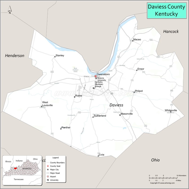
About Daviess County Map, Kentucky: The map showing the county boundary, county seat, major cities, highways, water bodies and neighbouring counties.
More Kentucky Maps & Info
Map of Daviess County, Kentucky
Daviess County is a county located in the U.S. state of Kentucky. It's county seat is Owensboro. As per 2020 census, the population of Daviess County is 103063 people and population density is square miles. According to the United States Census Bureau, the county has a total area of 462 sq mi (1,197 km2). Daviess County was established on 1815.
Daviess County Facts
| Continent | North America |
| Country | United States |
| State | Kentucky |
| County Seat | Owensboro |
| Largest City/Town | Owensboro |
| Established | 1815 |
| Total Area | 477 sq mi (1,235 sq km) |
| Land Area | 462 sq mi (1,197 sq km) |
| Water Area | 15 sq mi (39 sq km) |
| Population | 103,312 (Census 2020) |
| Population Density | 223 people per sq mi |
| Time Zone | Central Time Zone (CT) |
| Major Highways | U.S. Route 60, U.S. Route 431, Interstate 165, Wendell H. Ford Expressway, Kentucky Route 54 |
| Major Rivers | Ohio River, Yellow Creek |
| Neighboring Counties | Hancock County, McLean County, Ohio County, Henderson County, Spencer County (IN) |
| Famous For | Owensboro barbecue, bluegrass music, riverfront attractions, and western Kentucky industry |
| Top Attractions | Bluegrass Music Hall of Fame & Museum, Smothers Park, Owensboro Riverfront, Western Kentucky Botanical Garden, Panther Creek Park |
| Official Website | Official Website |
About Daviess County, Kentucky
Daviess County is located in northwestern Kentucky along the Ohio River and was established in 1815. The county seat and largest city is Owensboro, one of the largest cities in western Kentucky. Daviess County is known for its riverfront culture, barbecue traditions, bluegrass music heritage, manufacturing industries, and vibrant community events. ([en.wikipedia.org](https://en.wikipedia.org/wiki/Daviess_County%2C_Kentucky?utm_source=chatgpt.com))
Cities and Communities in Daviess County, Kentucky
| City/Town | Population | Latitude & Longitude |
|---|---|---|
| Owensboro (county seat) | 60,000+ | 37.7719°N, 87.1112°W |
| Maceo | Unincorporated | 37.8428°N, 87.0503°W |
| Moseleyville | Unincorporated | 37.7429°N, 87.0421°W |
| Whitesville | 1,000+ | 37.6761°N, 86.8714°W |
| Masonville | Unincorporated | 37.7156°N, 87.1378°W |
| Philpot | Unincorporated | 37.7345°N, 86.9851°W |
| Yelvington | Historic Community | 37.9362°N, 87.0009°W |
| Utica | 200+ | 37.6069°N, 87.1155°W |
Best Golf Courses in Daviess County, Kentucky
| Golf Course | Location | Latitude & Longitude |
|---|---|---|
| Ben Hawes Golf Course | Owensboro | 37.7350°N, 87.1268°W |
| Owensboro Country Club | Owensboro | 37.7439°N, 87.0972°W |
| The Pearl Club | Owensboro | 37.7445°N, 87.1778°W |
| Windridge Country Club | Owensboro Area | 37.6944°N, 87.0851°W |
What are Major Roads and Highways in Daviess County
Major highways connect Daviess County with western Kentucky, Indiana, and regional commercial centers.
- U.S. Route 60 - major east-west highway through Owensboro and western Kentucky
- U.S. Route 431 - north-south route linking Owensboro with Bowling Green and Indiana
- Interstate 165 - major interstate connector serving Owensboro and nearby counties
- Wendell H. Ford Expressway - bypass route around Owensboro metropolitan areas
- Kentucky Route 54 - regional connector serving suburban and commercial districts
Neighboring Counties of Daviess County
- Hancock County (north)
- McLean County (east)
- Ohio County (south)
- Henderson County (west)
- Spencer County, Indiana (north across the Ohio River)
What are Top Attractions in Daviess County, Kentucky
The county features riverfront parks, music heritage sites, museums, and family recreation destinations.
| Main Sight Name | City | Famous For |
|---|---|---|
| Bluegrass Music Hall of Fame & Museum | Owensboro | Bluegrass music history and live performances |
| Smothers Park | Owensboro | Ohio Riverfront playgrounds and fountains |
| Owensboro Riverfront | Owensboro | River walks, festivals, and entertainment venues |
| Western Kentucky Botanical Garden | Owensboro | Gardens, walking trails, and seasonal displays |
| Panther Creek Park | Owensboro Area | Hiking, biking, and outdoor recreation |
| Owensboro Museum of Science and History | Owensboro | Interactive exhibits and regional history |
| International Bluegrass Music Museum | Owensboro | Music exhibits and cultural heritage |
| Yellow Creek Park | Owensboro Area | Fishing lakes and picnic areas |
| Downtown Owensboro | Owensboro | Restaurants, shops, and entertainment districts |
| BBQ Festival Areas | Owensboro | Traditional Kentucky barbecue events and food culture |
Distance from Daviess County to Nearby Cities
The following distances are measured by road (driving).
- Owensboro to Evansville, Indiana - 38 mi (61 km)
- Owensboro to Bowling Green, Kentucky - 71 mi (114 km)
- Owensboro to Louisville, Kentucky - 107 mi (172 km)
- Owensboro to Nashville, Tennessee - 124 mi (200 km)
- Owensboro to Paducah, Kentucky - 109 mi (175 km)
- Owensboro to Henderson, Kentucky - 31 mi (50 km)
- Owensboro to Lexington, Kentucky - 181 mi (291 km)
- Owensboro to Indianapolis, Indiana - 170 mi (274 km)
- Owensboro to St. Louis, Missouri - 192 mi (309 km)
- Owensboro to Cincinnati, Ohio - 184 mi (296 km)
- Owensboro to Memphis, Tennessee - 242 mi (389 km)
- Owensboro to Chattanooga, Tennessee - 269 mi (433 km)
References
- Daviess County Official Website
- Daviess County, Kentucky - Wikipedia
- U.S. Census Bureau QuickFacts
- Visit Owensboro Tourism
- Kentucky Atlas and Gazetteer
- Adair County Map
- Allen County Map
- Anderson County Map
- Ballard County Map
- Barren County Map
- Bath County Map
- Bell County Map
- Boone County Map
- Bourbon County Map
- Boyd County Map
- Boyle County Map
- Bracken County Map
- Breathitt County Map
- Breckinridge County Map
- Bullitt County Map
- Butler County Map
- Caldwell County Map
- Calloway County Map
- Campbell County Map
- Carlisle County Map
- Carroll County Map
- Carter County Map
- Casey County Map
- Christian County Map
- Clark County Map
- Clay County Map
- Clinton County Map
- Crittenden County Map
- Cumberland County Map
- Daviess County Map
- Edmonson County Map
- Elliott County Map
- Estill County Map
- Fayette County Map
- Fleming County Map
- Floyd County Map
- Franklin County Map
- Fulton County Map
- Gallatin County Map
- Garrard County Map
- Grant County Map
- Graves County Map
- Grayson County Map
- Green County Map
- Greenup County Map
- Hancock County Map
- Hardin County Map
- Harlan County Map
- Harrison County Map
- Hart County Map
- Henderson County Map
- Henry County Map
- Hickman County Map
- Hopkins County Map
- Jackson County Map
- Jefferson County Map
- Jessamine County Map
- Johnson County Map
- Kenton County Map
- Knott County Map
- Knox County Map
- LaRue County Map
- Laurel County Map
- Lawrence County Map
- Lee County Map
- Leslie County Map
- Letcher County Map
- Lewis County Map
- Lincoln County Map
- Livingston County Map
- Logan County Map
- Lyon County Map
- McCracken County Map
- McCreary County Map
- McLean County Map
- Madison County Map
- Magoffin County Map
- Marion County Map
- Marshall County Map
- Martin County Map
- Mason County Map
- Meade County Map
- Menifee County Map
- Mercer County Map
- Metcalfe County Map
- Monroe County Map
- Montgomery County Map
- Morgan County Map
- Muhlenberg County Map
- Nelson County Map
- Nicholas County Map
- Ohio County Map
- Oldham County Map
- Owen County Map
- Owsley County Map
- Pendleton County Map
- Perry County Map
- Pike County Map
- Powell County Map
- Pulaski County Map
- Robertson County Map
- Rockcastle County Map
- Rowan County Map
- Russell County Map
- Scott County Map
- Shelby County Map
- Simpson County Map
- Spencer County Map
- Taylor County Map
- Todd County Map
- Trigg County Map
- Trimble County Map
- Union County Map
- Warren County Map
- Washington County Map
- Wayne County Map
- Webster County Map
- Whitley County Map
- Wolfe County Map
- Woodford County Map
- Alabama Counties
- Alaska boroughs
- Arizona Counties
- Arkansas Counties
- California County Map
- Colorado Counties
- Connecticut Counties
- Delaware Counties
- Florida County Map
- Georgia County Map
- Hawaii Counties
- Idaho Counties
- Illinois Counties
- Indiana Counties
- Iowa Counties
- Kansas Counties
- Kentucky Counties
- Louisiana Counties
- Maine Counties
- Maryland Counties
- Massachusetts Counties
- Michigan County Map
- Minnesota Counties
- Mississippi Counties
- Missouri Counties
- Montana Counties
- Nebraska Counties
- Nevada Counties
- New York Counties
- New Hampshire Counties
- New Jersey Counties
- New Mexico Counties
- North Carolina Counties
- North Dakota Counties
- Ohio County Map
- Oklahoma Counties
- Oregon Counties
- Pennsylvania Counties
- Rhode Island Counties
- South Carolina Counties
- South Dakota Counties
- Map of Tennessee
- Texas County Map
- Utah Counties
- Vermont Counties
- Virginia Counties
- Washington Counties
- West Virginia Counties
- Wisconsin Counties
- Wyoming Counties