Map of Pendleton County - Pendleton County is a county located in the U.S. state of Kentucky. Pendleton County Map showing cities, highways, important places and water bodies. Get Where is Pendleton County located in the map, major cities in Pendleton county, population, areas, and places of interest.
Map of Pendleton County, Kentucky
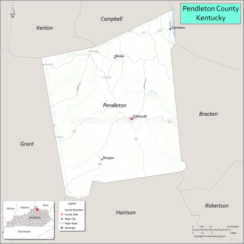
About Pendleton County Map, Kentucky: The map showing the county boundary, county seat, major cities, highways, water bodies and neighbouring counties.
More Kentucky Maps & Info
Map of Pendleton County, Kentucky
Pendleton County is a county located in the U.S. state of Kentucky. It's county seat is Falmouth. As per 2020 census, the population of Pendleton County is 14607 people and population density is square miles. According to the United States Census Bureau, the county has a total area of 280 sq mi (725 km2). Pendleton County was established on 1798.
Pendleton County Facts
| Continent | North America |
| Country | United States |
| State | Kentucky |
| County Seat | Falmouth |
| Largest City/Town | Falmouth |
| Established | 1798 |
| Total Area | 282 sq mi (730 sq km) |
| Land Area | 277 sq mi (717 sq km) |
| Water Area | 4.8 sq mi (12 sq km) |
| Population | 14,644 (Census 2020) |
| Population Density | 53 people per sq mi |
| Time Zone | Eastern Time Zone (ET) |
| Major Highways | U.S. Route 27, Kentucky Route 22, Kentucky Route 17, Kentucky Route 330 |
| Major Rivers | Licking River, Ohio River |
| Neighboring Counties | Kenton County, Campbell County, Bracken County, Harrison County, Grant County, Clermont County (OH) |
| Famous For | Kentucky Wool Festival, rolling Northern Kentucky hills, river scenery, and rural Bluegrass heritage |
| Top Attractions | Kentucky Wool Festival, Kincaid Lake State Park nearby area, Griffin Centre Amphitheater, Falmouth Historic District, General Butler State Resort Park nearby area |
| Official Website | Official Website |
About Pendleton County, Kentucky
Pendleton County is located in northern Kentucky between Cincinnati and Lexington and was established in 1798. The county seat and largest city is Falmouth. Pendleton County is known for scenic rolling hills, outdoor recreation, river valleys, agricultural heritage, and the famous Kentucky Wool Festival held each year in Falmouth. :contentReference[oaicite:0]{index=0}
Cities and Communities in Pendleton County, Kentucky
| City/Town | Population | Latitude & Longitude |
|---|---|---|
| Falmouth (county seat) | 2,200+ | 38.6767°N, 84.3302°W |
| Butler | 600+ | 38.7862°N, 84.3699°W |
| DeMossville | Historic Community | 38.6770°N, 84.4355°W |
| Lenoxburg | Rural Community | 38.6118°N, 84.2908°W |
| Locust Grove | Small Community | 38.7425°N, 84.4231°W |
| Morgan | Unincorporated | 38.7341°N, 84.3352°W |
| Peach Grove | Rural Area | 38.6614°N, 84.4863°W |
| Neave | Historic Area | 38.7278°N, 84.2849°W |
Best Golf Courses in Pendleton County, Kentucky
| Golf Course | Location | Latitude & Longitude |
|---|---|---|
| Hickory Sticks Golf Club | Nearby Alexandria | 38.9594°N, 84.3996°W |
| Kenton Station Golf Course | Nearby Maysville | 38.6628°N, 83.7592°W |
| Eagle Creek Country Club | Nearby Crittenden | 38.7836°N, 84.6042°W |
| Devou Park Golf Course | Nearby Covington | 39.0742°N, 84.5348°W |
What are Major Roads and Highways in Pendleton County
Major highways connect Pendleton County with Cincinnati, northern Kentucky communities, and central Kentucky regions.
- U.S. Route 27 - major north-south highway through Falmouth and Butler
- Kentucky Route 22 - scenic regional route through northern Kentucky farmland
- Kentucky Route 17 - important connector roadway linking rural communities
- Kentucky Route 330 - regional transportation corridor through eastern county areas
Neighboring Counties of Pendleton County
- Kenton County (northwest)
- Campbell County (north)
- Bracken County (east)
- Harrison County (south)
- Grant County (west)
- Clermont County, Ohio (northeast across the Ohio River)
What are Top Attractions in Pendleton County, Kentucky
The county offers outdoor recreation, festivals, river scenery, and historic northern Kentucky attractions. :contentReference[oaicite:1]{index=1}
| Main Sight Name | City | Famous For |
|---|---|---|
| Kentucky Wool Festival | Falmouth | Annual crafts, wool, and heritage festival |
| Kincaid Lake State Park Nearby Area | Regional Area | Fishing, boating, camping, and hiking |
| Griffin Centre Amphitheater | Falmouth | Concerts and community entertainment events |
| Falmouth Historic District | Falmouth | Historic downtown architecture and local shops |
| General Butler State Resort Park Nearby Area | Regional Area | Scenic overlooks and outdoor recreation |
| Licking River Recreation Areas | Countywide | Fishing, kayaking, and river scenery |
| Scenic Northern Kentucky Drives | Countywide | Rolling hills and countryside photography |
| Historic Rural Churches | Countywide | Architectural heritage and local traditions |
| Community Heritage Festivals | Countywide | Seasonal celebrations and local culture |
| Ohio River Scenic Areas | Northern County Area | River views and outdoor recreation |
Distance from Pendleton County to Nearby Cities
The following distances are measured by road (driving).
- Falmouth to Cincinnati, Ohio - 38 mi (61 km)
- Falmouth to Covington, Kentucky - 41 mi (66 km)
- Falmouth to Lexington, Kentucky - 63 mi (101 km)
- Falmouth to Louisville, Kentucky - 101 mi (163 km)
- Falmouth to Columbus, Ohio - 128 mi (206 km)
- Falmouth to Indianapolis, Indiana - 126 mi (203 km)
- Falmouth to Huntington, West Virginia - 147 mi (237 km)
- Falmouth to Charleston, West Virginia - 188 mi (303 km)
- Falmouth to Nashville, Tennessee - 264 mi (425 km)
- Falmouth to Knoxville, Tennessee - 252 mi (406 km)
- Falmouth to Chicago, Illinois - 305 mi (491 km)
- Falmouth to St. Louis, Missouri - 355 mi (571 km)
References
- Pendleton County Official Website
- Pendleton County, Kentucky - Wikipedia
- U.S. Census Bureau QuickFacts
- Kincaid Lake State Park
- Kentucky Tourism
- Adair County Map
- Allen County Map
- Anderson County Map
- Ballard County Map
- Barren County Map
- Bath County Map
- Bell County Map
- Boone County Map
- Bourbon County Map
- Boyd County Map
- Boyle County Map
- Bracken County Map
- Breathitt County Map
- Breckinridge County Map
- Bullitt County Map
- Butler County Map
- Caldwell County Map
- Calloway County Map
- Campbell County Map
- Carlisle County Map
- Carroll County Map
- Carter County Map
- Casey County Map
- Christian County Map
- Clark County Map
- Clay County Map
- Clinton County Map
- Crittenden County Map
- Cumberland County Map
- Daviess County Map
- Edmonson County Map
- Elliott County Map
- Estill County Map
- Fayette County Map
- Fleming County Map
- Floyd County Map
- Franklin County Map
- Fulton County Map
- Gallatin County Map
- Garrard County Map
- Grant County Map
- Graves County Map
- Grayson County Map
- Green County Map
- Greenup County Map
- Hancock County Map
- Hardin County Map
- Harlan County Map
- Harrison County Map
- Hart County Map
- Henderson County Map
- Henry County Map
- Hickman County Map
- Hopkins County Map
- Jackson County Map
- Jefferson County Map
- Jessamine County Map
- Johnson County Map
- Kenton County Map
- Knott County Map
- Knox County Map
- LaRue County Map
- Laurel County Map
- Lawrence County Map
- Lee County Map
- Leslie County Map
- Letcher County Map
- Lewis County Map
- Lincoln County Map
- Livingston County Map
- Logan County Map
- Lyon County Map
- McCracken County Map
- McCreary County Map
- McLean County Map
- Madison County Map
- Magoffin County Map
- Marion County Map
- Marshall County Map
- Martin County Map
- Mason County Map
- Meade County Map
- Menifee County Map
- Mercer County Map
- Metcalfe County Map
- Monroe County Map
- Montgomery County Map
- Morgan County Map
- Muhlenberg County Map
- Nelson County Map
- Nicholas County Map
- Ohio County Map
- Oldham County Map
- Owen County Map
- Owsley County Map
- Pendleton County Map
- Perry County Map
- Pike County Map
- Powell County Map
- Pulaski County Map
- Robertson County Map
- Rockcastle County Map
- Rowan County Map
- Russell County Map
- Scott County Map
- Shelby County Map
- Simpson County Map
- Spencer County Map
- Taylor County Map
- Todd County Map
- Trigg County Map
- Trimble County Map
- Union County Map
- Warren County Map
- Washington County Map
- Wayne County Map
- Webster County Map
- Whitley County Map
- Wolfe County Map
- Woodford County Map
- Alabama Counties
- Alaska boroughs
- Arizona Counties
- Arkansas Counties
- California County Map
- Colorado Counties
- Connecticut Counties
- Delaware Counties
- Florida County Map
- Georgia County Map
- Hawaii Counties
- Idaho Counties
- Illinois Counties
- Indiana Counties
- Iowa Counties
- Kansas Counties
- Kentucky Counties
- Louisiana Counties
- Maine Counties
- Maryland Counties
- Massachusetts Counties
- Michigan County Map
- Minnesota Counties
- Mississippi Counties
- Missouri Counties
- Montana Counties
- Nebraska Counties
- Nevada Counties
- New York Counties
- New Hampshire Counties
- New Jersey Counties
- New Mexico Counties
- North Carolina Counties
- North Dakota Counties
- Ohio County Map
- Oklahoma Counties
- Oregon Counties
- Pennsylvania Counties
- Rhode Island Counties
- South Carolina Counties
- South Dakota Counties
- Map of Tennessee
- Texas County Map
- Utah Counties
- Vermont Counties
- Virginia Counties
- Washington Counties
- West Virginia Counties
- Wisconsin Counties
- Wyoming Counties