Map of Todd County - Todd County is a county located in the U.S. state of Kentucky. Todd County Map showing cities, highways, important places and water bodies. Get Where is Todd County located in the map, major cities in Todd county, population, areas, and places of interest.
Map of Todd County, Kentucky
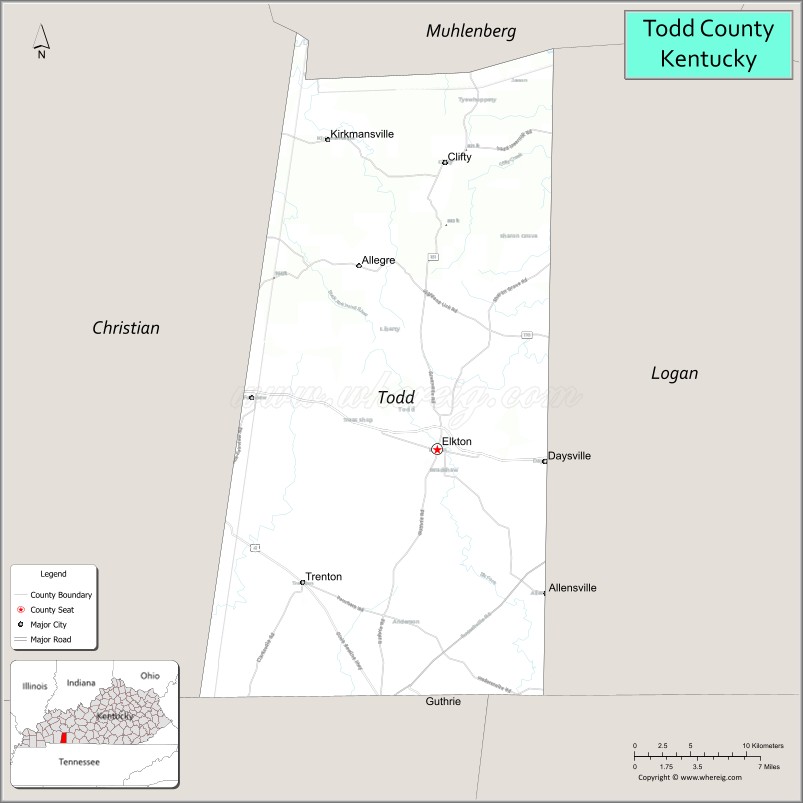
About Todd County Map, Kentucky: The map showing the county boundary, county seat, major cities, highways, water bodies and neighbouring counties.
More Kentucky Maps & Info
Map of Todd County, Kentucky
Todd County is a county located in the U.S. state of Kentucky. It's county seat is Elkton. As per 2020 census, the population of Todd County is 12285 people and population density is square miles. According to the United States Census Bureau, the county has a total area of 376 sq mi (974 km2). Todd County was established on 1819.
Todd County Facts
| Continent | North America |
| Country | United States |
| State | Kentucky |
| County Seat | Elkton |
| Largest City/Town | Elkton |
| Established | 1820 |
| Total Area | 376 sq mi (974 sq km) |
| Land Area | 374 sq mi (969 sq km) |
| Water Area | 1.8 sq mi (5 sq km) |
| Population | 12,243 (Census 2020) |
| Population Density | 33 people per sq mi |
| Time Zone | Central Time Zone (CT) |
| Major Highways | U.S. Route 68, Kentucky Route 181, Kentucky Route 102, Western Kentucky Parkway nearby area |
| Major Rivers | Red River tributaries |
| Neighboring Counties | Christian County, Logan County, Muhlenberg County, Trigg County, Montgomery County (TN) |
| Famous For | Agriculture, scenic countryside, Jefferson Davis birthplace nearby area, and rural southern Kentucky heritage |
| Top Attractions | Jefferson Davis State Historic Site nearby area, Historic Elkton Square, Lake Malone nearby area, Todd County Welcome Center, scenic rural drives |
| Official Website | Official Website |
About Todd County, Kentucky
Todd County is located in southwestern Kentucky along the Tennessee border and was established in 1820. The county seat and largest city is Elkton. Todd County is known for its agricultural traditions, rolling countryside, tobacco farming history, and proximity to the Jefferson Davis State Historic Site, which commemorates the birthplace of the Confederate president. ([en.wikipedia.org](https://en.wikipedia.org/wiki/Todd_County%2C_Kentucky?utm_source=chatgpt.com))
Cities and Communities in Todd County, Kentucky
| City/Town | Population | Latitude & Longitude |
|---|---|---|
| Elkton (county seat) | 2,000+ | 36.8109°N, 87.1544°W |
| Trenton | 400+ | 36.7220°N, 87.2628°W |
| Allensville | Small Community | 36.7162°N, 87.0717°W |
| Clifty | Rural Community | 37.0113°N, 87.1438°W |
| Kirkmansville | Historic Community | 36.8585°N, 87.0649°W |
| Allegre | Agricultural Area | 36.8953°N, 87.0847°W |
| Guthrie Nearby Area | Regional Community | 36.6664°N, 87.1708°W |
| Daysville | Unincorporated | 36.9251°N, 87.2176°W |
Best Golf Courses in Todd County, Kentucky
| Golf Course | Location | Latitude & Longitude |
|---|---|---|
| Links at Novadell | Nearby Hopkinsville | 36.8607°N, 87.5221°W |
| The Mill Golf Course | Nearby Waverly, TN | 36.0874°N, 87.8204°W |
| Franklin Country Club | Nearby Franklin | 36.7197°N, 86.5862°W |
| Kenny Perry's Country Creek Golf Course | Nearby Franklin | 36.7448°N, 86.5825°W |
What are Major Roads and Highways in Todd County
Major highways connect Todd County with southwestern Kentucky communities, Tennessee, and regional agricultural areas.
- U.S. Route 68 - major east-west highway through Elkton and nearby communities
- Kentucky Route 181 - important north-south roadway serving rural areas
- Kentucky Route 102 - regional connector route through farmland landscapes
- Western Kentucky Parkway nearby area - transportation corridor linking western Kentucky destinations
Neighboring Counties of Todd County
- Christian County (west)
- Logan County (east)
- Muhlenberg County (north)
- Trigg County (northwest)
- Montgomery County, Tennessee (south)
What are Top Attractions in Todd County, Kentucky
The county offers historic sites, countryside scenery, agricultural heritage, and peaceful southern Kentucky attractions.
| Main Sight Name | City | Famous For |
|---|---|---|
| Jefferson Davis State Historic Site Nearby Area | Fairview Area | Historic monument and museum dedicated to Jefferson Davis |
| Historic Elkton Square | Elkton | Historic courthouse and small-town architecture |
| Lake Malone Nearby Area | Regional Area | Fishing, boating, hiking, and outdoor recreation |
| Todd County Welcome Center | Elkton | Local tourism information and regional exhibits |
| Scenic Rural Drives | Countywide | Rolling farmland and countryside photography |
| Historic Tobacco Farm Areas | Countywide | Agricultural heritage and Kentucky farming traditions |
| Community Heritage Festivals | Elkton Area | Local celebrations and seasonal entertainment |
| Outdoor Nature Areas | Countywide | Wildlife viewing and quiet recreation |
| Southern Kentucky Countryside | Countywide | Scenic landscapes and rural atmosphere |
| Historic Rural Churches | Countywide | Architectural heritage and local history |
Distance from Todd County to Nearby Cities
The following distances are measured by road (driving).
- Elkton to Hopkinsville, Kentucky - 23 mi (37 km)
- Elkton to Clarksville, Tennessee - 38 mi (61 km)
- Elkton to Bowling Green, Kentucky - 63 mi (101 km)
- Elkton to Nashville, Tennessee - 74 mi (119 km)
- Elkton to Paducah, Kentucky - 106 mi (171 km)
- Elkton to Louisville, Kentucky - 164 mi (264 km)
- Elkton to Evansville, Indiana - 123 mi (198 km)
- Elkton to Memphis, Tennessee - 214 mi (344 km)
- Elkton to Knoxville, Tennessee - 253 mi (407 km)
- Elkton to Indianapolis, Indiana - 267 mi (430 km)
- Elkton to Cincinnati, Ohio - 257 mi (414 km)
- Elkton to Atlanta, Georgia - 280 mi (451 km)
References
- Todd County Official Website
- Todd County, Kentucky - Wikipedia
- U.S. Census Bureau QuickFacts
- Jefferson Davis State Historic Site
- Kentucky Tourism
- Adair County Map
- Allen County Map
- Anderson County Map
- Ballard County Map
- Barren County Map
- Bath County Map
- Bell County Map
- Boone County Map
- Bourbon County Map
- Boyd County Map
- Boyle County Map
- Bracken County Map
- Breathitt County Map
- Breckinridge County Map
- Bullitt County Map
- Butler County Map
- Caldwell County Map
- Calloway County Map
- Campbell County Map
- Carlisle County Map
- Carroll County Map
- Carter County Map
- Casey County Map
- Christian County Map
- Clark County Map
- Clay County Map
- Clinton County Map
- Crittenden County Map
- Cumberland County Map
- Daviess County Map
- Edmonson County Map
- Elliott County Map
- Estill County Map
- Fayette County Map
- Fleming County Map
- Floyd County Map
- Franklin County Map
- Fulton County Map
- Gallatin County Map
- Garrard County Map
- Grant County Map
- Graves County Map
- Grayson County Map
- Green County Map
- Greenup County Map
- Hancock County Map
- Hardin County Map
- Harlan County Map
- Harrison County Map
- Hart County Map
- Henderson County Map
- Henry County Map
- Hickman County Map
- Hopkins County Map
- Jackson County Map
- Jefferson County Map
- Jessamine County Map
- Johnson County Map
- Kenton County Map
- Knott County Map
- Knox County Map
- LaRue County Map
- Laurel County Map
- Lawrence County Map
- Lee County Map
- Leslie County Map
- Letcher County Map
- Lewis County Map
- Lincoln County Map
- Livingston County Map
- Logan County Map
- Lyon County Map
- McCracken County Map
- McCreary County Map
- McLean County Map
- Madison County Map
- Magoffin County Map
- Marion County Map
- Marshall County Map
- Martin County Map
- Mason County Map
- Meade County Map
- Menifee County Map
- Mercer County Map
- Metcalfe County Map
- Monroe County Map
- Montgomery County Map
- Morgan County Map
- Muhlenberg County Map
- Nelson County Map
- Nicholas County Map
- Ohio County Map
- Oldham County Map
- Owen County Map
- Owsley County Map
- Pendleton County Map
- Perry County Map
- Pike County Map
- Powell County Map
- Pulaski County Map
- Robertson County Map
- Rockcastle County Map
- Rowan County Map
- Russell County Map
- Scott County Map
- Shelby County Map
- Simpson County Map
- Spencer County Map
- Taylor County Map
- Todd County Map
- Trigg County Map
- Trimble County Map
- Union County Map
- Warren County Map
- Washington County Map
- Wayne County Map
- Webster County Map
- Whitley County Map
- Wolfe County Map
- Woodford County Map
- Alabama Counties
- Alaska boroughs
- Arizona Counties
- Arkansas Counties
- California County Map
- Colorado Counties
- Connecticut Counties
- Delaware Counties
- Florida County Map
- Georgia County Map
- Hawaii Counties
- Idaho Counties
- Illinois Counties
- Indiana Counties
- Iowa Counties
- Kansas Counties
- Kentucky Counties
- Louisiana Counties
- Maine Counties
- Maryland Counties
- Massachusetts Counties
- Michigan County Map
- Minnesota Counties
- Mississippi Counties
- Missouri Counties
- Montana Counties
- Nebraska Counties
- Nevada Counties
- New York Counties
- New Hampshire Counties
- New Jersey Counties
- New Mexico Counties
- North Carolina Counties
- North Dakota Counties
- Ohio County Map
- Oklahoma Counties
- Oregon Counties
- Pennsylvania Counties
- Rhode Island Counties
- South Carolina Counties
- South Dakota Counties
- Map of Tennessee
- Texas County Map
- Utah Counties
- Vermont Counties
- Virginia Counties
- Washington Counties
- West Virginia Counties
- Wisconsin Counties
- Wyoming Counties