
Treasure Island is a coastal city in west-central Florida and part of the Tampa Bay metropolitan area in Pinellas County. Located about 10 miles west of St. Petersburg, the city occupies a barrier island on the Gulf of Mexico. Treasure Island is known for its sandy beaches, waterfront parks, Gulf sunsets, and relaxed beach-town character.
Location Map of Treasure Island, Pinellas County, Florida
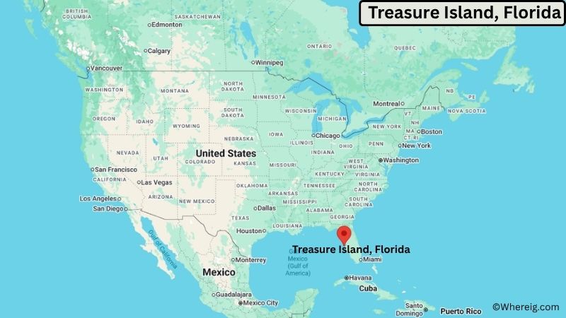
About Map: The map shows the location of Treasure Island in Pinellas County, in the U.S. state of Florida.
Treasure Island Map, Florida
About Treasure Island Map: The Google Map highlights the location of Treasure Island in Pinellas County, Florida. Use the zoom, satellite, and street-view options to explore the city's neighborhoods, roads, and nearby places.
Where is Treasure Island Located?
Treasure Island is a city located in Pinellas County, Florida, the United States. It lies on a barrier island along the Gulf of Mexico, about 10 miles west of St. Petersburg and roughly 25 miles southwest of Clearwater. Madeira Beach is about 3 miles north, while Gulfport is approximately 5 miles southeast of Treasure Island. The city is located at 27.7692° North latitude and 82.7687° West longitude. The 2020 Census recorded 6,584 residents. Treasure Island covers about 5.30 square miles, or approximately 13.73 square kilometers, including its surrounding water area. The city is known for its broad sandy beaches, warm Gulf waters, waterfront parks, and coastal views. Treasure Island Beach is one of the area's best-known attractions and provides opportunities for swimming, fishing, boating, walking, and watching sunsets. The city developed as a residential and tourism community during the 20th century and remains closely tied to the Gulf of Mexico. John's Pass Village and Boardwalk, located just north of the city, offers shops, restaurants, boat tours, fishing charters, and access to the Intracoastal Waterway. A unique feature of Treasure Island is its location on a barrier island between the Gulf of Mexico and the Intracoastal Waterway, giving the city extensive waterfront access.
Most Viewed US Maps
| USA Sttae Map | USA Region Map | USA Road Map |
| USA County Map | Where is USA in World Map? | US ZIP Code Map |
| USA Time Zones Map | US State and Capitals Map | USA Physical Map |
Find 4,400+ U.S. Cities by State - Explore Their Locations and Get Detailed Information
Treasure Island City Facts
| Fact | Details |
|---|---|
| City | Treasure Island |
| State | Florida |
| County | Pinellas County |
| Country | United States |
| Region | West-Central Florida, Tampa Bay Area |
| Incorporated | 1955 |
| Founded | 1915 |
| Total Area | 5.30 sq mi (13.73 sq km) |
| Land Area | 1.58 sq mi (4.09 sq km) |
| Water Area | 3.72 sq mi (9.64 sq km) |
| Elevation | About 7 ft (2 m) |
| Population (2023 estimate) | About 6,500 |
| Population (2020 Census) | 6,584 |
| Population Density | About 4,167 people per sq mi |
| Time Zone | Eastern Time (EST/EDT) |
| ZIP Codes | 33706 |
| Area Code | 727 |
| Major Highways | Gulf Boulevard, Gulf Boulevard Causeway, Pinellas Bayway |
| Public Transit | Pinellas SunRunner and PSTA bus services |
| Major Attractions | Treasure Island Beach, Sunset Beach, John's Pass Village and Boardwalk, Treasure Island Beach Trail, Gulf of Mexico |
| Official Website | https://www.mytreasureisland.org/ |
Distance from Treasure Island, FL to Nearby Cities
- Madeira Beach, FL – 3 miles (5 km)
- Gulfport, FL – 5 miles (8 km)
- St. Pete Beach, FL – 5 miles (8 km)
- St. Petersburg, FL – 10 miles (16 km)
- Clearwater, FL – 25 miles (40 km)
- Largo, FL – 15 miles (24 km)
- Seminole, FL – 12 miles (19 km)
- Pinellas Park, FL – 15 miles (24 km)
- Tampa, FL – 30 miles (48 km)
- Safety Harbor, FL – 30 miles (48 km)
- Dunedin, FL – 25 miles (40 km)
- Tarpon Springs, FL – 35 miles (56 km)
- Bradenton, FL – 35 miles (56 km)
- Sarasota, FL – 50 miles (80 km)
- Venice, FL – 65 miles (105 km)
- Spring Hill, FL – 55 miles (89 km)
- Lakeland, FL – 60 miles (97 km)
- Orlando, FL – 115 miles (185 km)
Top Attractions in Treasure Island
- Treasure Island Beach – A wide Gulf beach popular for swimming, sunbathing, walking, shell collecting, and watching sunsets.
- Sunset Beach – A quieter beach area on the southern end of Treasure Island known for Gulf views and evening sunsets.
- John's Pass Village and Boardwalk – A nearby waterfront attraction with shops, restaurants, fishing charters, boat tours, and access to the Intracoastal Waterway.
- Treasure Island Beach Trail – A scenic walking and cycling route along the Gulf shoreline connecting several beach areas.
- Gulf of Mexico – The city's western waterfront provides opportunities for swimming, boating, fishing, kayaking, paddleboarding, and wildlife viewing.
- Treasure Island Community Center Park – A local recreational area with open space, walking areas, and facilities for community activities.
- Blind Pass – A natural waterway separating Treasure Island from nearby beaches and providing access to fishing, boating, and scenic coastal habitats.
- Fort De Soto Park – A large nearby coastal park with beaches, trails, historic fortifications, fishing areas, and natural habitats.
- St. Pete Beach – A neighboring barrier-island community with additional beaches, waterfront recreation, restaurants, and historic attractions.
Airports Near Treasure Island, Florida
- St. Pete-Clearwater International Airport (PIE) – 20 miles
- Tampa International Airport (TPA) – 25 miles
- Albert Whitted Airport (SPG) – 10 miles
- Sarasota-Bradenton International Airport (SRQ) – 45 miles
- Lakeland Linder International Airport (LAL) – 60 miles
Sources:
Population and area data sourced from the United States Census Bureau (2020 Census). General city information referenced from the official Treasure Island city website and local government records.
Florida Related Maps and Info
- Where is Miami
- Where is Hialeah
- Where is Jacksonville
- Where is Orlando
- Where is Saint Petersburg
- Where is Tampa
- Where is Alafaya
- Where is Boca Raton
- Where is Boynton Beach
- Where is Brandon
- Where is Cape Coral
- Where is Clearwater
- Where is Coral Springs
- Where is Davie
- Where is Daytona Beach
- Where is Deerfield Beach
- Where is Deltona
- Where is Doral
- Where is Fort Lauderdale
- Where is Fort Myers
- Where is Gainesville
- Where is Hollywood
- Where is Homestead
- Where is Horizon West
- Where is Kendall
- Where is Kissimmee
- Where is Lakeland
- Where is Largo
- Where is Lauderhill
- Where is Lehigh Acres
- Where is Melbourne
- Where is Miami Beach
- Where is Miami Gardens
- Where is Miramar
- Where is North Port
- Where is Palm Bay
- Where is Palm Coast
- Where is Pembroke Pines
- Where is Plantation
- Where is Poinciana
- Where is Pompano Beach
- Where is Port St. Lucie
- Where is Riverview
- Where is Spring Hill
- Where is St. Petersburg
- Where is Sunrise
- Where is Tallahassee
- Where is Tamarac
- Where is The Villages
- Where is Town 'n' Country
- Where is West Palm Beach