Written and Fact-checked by Mukesh Kumar | Updated On: May 05, 2026 | 06:50 ET
Map of Churchill County - Churchill County is a county located in the U.S. state of Nevada. Churchill County Map showing cities, highways, important places and water bodies. Get Where is Churchill County located in the map, major cities in Churchill county, population, areas, and places of interest.
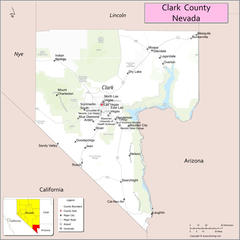
Map of Clark County, Nevada
About Churchill County Map, Nevada: The map showing the county boundary, county seat, major cities, highways, water bodies and neighbouring counties.
Related Nevada Links
Map of Clark County, Nevada
Clark County is a county located in the U.S. state of Nevada. It's county seat is Las Vegas. As per 2020 census, the population of Clark County is 2292476 people and population density is square miles. According to the United States Census Bureau, the county has a total area of 7,911 sq mi (20,489 km2). Clark County was established on 1909.
Clark County Facts
| Continent | North America |
| Country | United States |
| State | Nevada |
| County Seat | Las Vegas |
| Largest City/Town | Las Vegas |
| Established | 1909 |
| Total Area | 8,061 sq mi (20,878 sq km) |
| Land Area | 7,891 sq mi (20,444 sq km) |
| Water Area | 170 sq mi (440 sq km) |
| Population | 2,265,461 (Census 2020) |
| Population Density | 287 people per sq mi |
| Time Zone | Pacific Time Zone (PT) |
| Major Highways | I-15, I-11, US-93, US-95, US-515 |
| Major Rivers | Colorado River, Virgin River, Muddy River |
| Neighboring Counties | Nye County, Lincoln County, Mohave County (AZ), San Bernardino County (CA), Inyo County (CA) |
| Famous For | Las Vegas Strip, casinos, entertainment, tourism |
| Top Attractions | Las Vegas Strip, Hoover Dam, Red Rock Canyon, Lake Mead National Recreation Area |
| Official Website | Official Website |
About Clark County, Nevada
Clark County is located in the southern part of Nevada, in the United States, and was established in 1909. The county seat is Las Vegas, which is also the largest city and the economic center of Nevada. The county lies in the Mojave Desert and is known worldwide for its tourism industry, entertainment, casinos, and natural attractions such as the Colorado River and surrounding desert landscapes.
Cities and Towns in Clark County, Nevada
| City/Town | Population (Census 2020) | Latitude & Longitude |
|---|---|---|
| Las Vegas (county seat) | 641,903 | 36.1699°N, 115.1398°W |
| Henderson | 317,610 | 36.0395°N, 114.9817°W |
| North Las Vegas | 262,527 | 36.1989°N, 115.1175°W |
| Boulder City | 14,885 | 35.9786°N, 114.8325°W |
| Mesquite | 20,471 | 36.8055°N, 114.0672°W |
| Laughlin | 8,658 | 35.1678°N, 114.5730°W |
| Enterprise (CDP) | 221,831 | 36.0250°N, 115.2419°W |
| Spring Valley (CDP) | 215,597 | 36.1000°N, 115.2600°W |
| Paradise (CDP) | 191,238 | 36.0800°N, 115.1500°W |
Golf Courses in Clark County, Nevada
| Golf Course | Location | Latitude & Longitude |
|---|---|---|
| Shadow Creek Golf Course | North Las Vegas | 36.2300°N, 115.1300°W |
| Rio Secco Golf Club | Henderson | 36.0200°N, 115.0300°W |
| Bali Hai Golf Club | Las Vegas Strip | 36.0800°N, 115.1700°W |
Roads and Highways in Clark County, Nevada
Clark County is a major transportation hub in southern Nevada.
- I-15 – major north–south interstate connecting Las Vegas to California and Utah
- I-11 – connects Las Vegas to Arizona
- US-93 – runs through the county and across Hoover Dam
- US-95 – major route connecting Las Vegas to Reno
- US-515 – connects Las Vegas to Henderson and Boulder City
Neighboring Counties of Clark County
- Nye County (northwest)
- Lincoln County (north)
- Mohave County, Arizona (east)
- San Bernardino County, California (southwest)
- Inyo County, California (west)
Top Attractions in Clark County, Nevada
The county offers world-famous entertainment, natural wonders, and outdoor recreation.
- Las Vegas Strip – casinos, hotels, and entertainment venues
- Hoover Dam – engineering landmark on the Colorado River
- Red Rock Canyon National Conservation Area – hiking and scenic drives
- Lake Mead National Recreation Area – boating, fishing, and camping
- Fremont Street Experience – historic downtown entertainment district
- Valley of Fire State Park – unique red rock formations
Distance from Clark County to Nearby Cities
- Las Vegas to Los Angeles, CA – 270 mi (435 km)
- Las Vegas to Phoenix, AZ – 300 mi (483 km)
- Las Vegas to Salt Lake City, UT – 420 mi (676 km)
- Las Vegas to Reno, NV – 450 mi (724 km)
- Las Vegas to San Diego, CA – 330 mi (531 km)
FAQs about Clark County
Clark County is located in southern Nevada in the Mojave Desert.
The population of Clark County is 2,265,461 according to the 2020 Census.
Clark County is known for Las Vegas, entertainment, casinos, and tourism.
Major highways include I-15, I-11, US-93, US-95, and US-515.
Yes, Clark County has golf courses including Shadow Creek Golf Course, Rio Secco Golf Club, and Bali Hai Golf Club.
- Churchill County Map
- Clark County Map
- Douglas County Map
- Elko County Map
- Esmeralda County Map
- Eureka County Map
- Humboldt County Map
- Lander County Map
- Lincoln County Map
- Lyon County Map
- Mineral County Map
- Nye County Map
- Pershing County Map
- Storey County Map
- Washoe County Map
- White Pine County Map
- Carson County Map
- Alabama Counties
- Alaska boroughs
- Arizona Counties
- Arkansas Counties
- California County Map
- Colorado Counties
- Connecticut Counties
- Delaware Counties
- Florida County Map
- Georgia County Map
- Hawaii Counties
- Idaho Counties
- Illinois Counties
- Indiana Counties
- Iowa Counties
- Kansas Counties
- Kentucky Counties
- Louisiana Counties
- Maine Counties
- Maryland Counties
- Massachusetts Counties
- Michigan County Map
- Minnesota Counties
- Mississippi Counties
- Missouri Counties
- Montana Counties
- Nebraska Counties
- Nevada Counties
- New York Counties
- New Hampshire Counties
- New Jersey Counties
- New Mexico Counties
- North Carolina Counties
- North Dakota Counties
- Ohio County Map
- Oklahoma Counties
- Oregon Counties
- Pennsylvania Counties
- Rhode Island Counties
- South Carolina Counties
- South Dakota Counties
- Map of Tennessee
- Texas County Map
- Utah Counties
- Vermont Counties
- Virginia Counties
- Washington Counties
- West Virginia Counties
- Wisconsin Counties
- Wyoming Counties