
Written and Fact-checked by Mukesh Kumar | Updated On: May 05, 2026 | 06:50 ET
Map of Lyon County - Lyon County is a county located in the U.S. state of Nevada. Lyon County Map showing cities, highways, important places and water bodies. Get Where is Lyon County located in the map, major cities in Lyon county, population, areas, and places of interest.
Map of Mineral County, Nevada
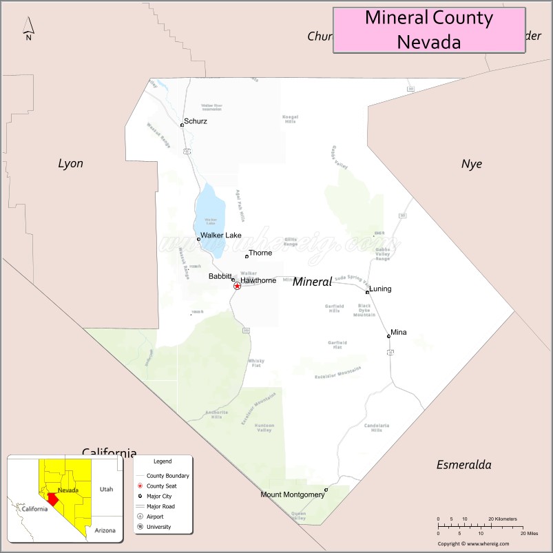
About Lyon County Map, Nevada: The map showing the county boundary, county seat, major cities, highways, water bodies and neighbouring counties.
Related Nevada Links
Map of Mineral County, Nevada
Mineral County is a county located in the U.S. state of Nevada. It's county seat is Hawthorne. As per 2020 census, the population of Mineral County is 4586 people and population density is square miles. According to the United States Census Bureau, the county has a total area of 3,757 sq mi (9,731 km2). Mineral County was established on 1911.
Mineral County Facts
| Continent | North America |
| Country | United States |
| State | Nevada |
| County Seat | Hawthorne |
| Largest City/Town | Hawthorne |
| Established | 1911 |
| Total Area | 3,813 sq mi (9,876 sq km) |
| Land Area | 3,753 sq mi (9,721 sq km) |
| Water Area | 60 sq mi (155 sq km) |
| Population | 4,731 (Census 2020) |
| Population Density | 1.3 people per sq mi |
| Time Zone | Pacific Time Zone (PT) |
| Major Highways | US-95, US-6, NV-359 |
| Major Rivers | Walker River |
| Neighboring Counties | Lyon County, Churchill County, Nye County, Esmeralda County, Mono County (CA) |
| Famous For | Walker Lake, Hawthorne Army Depot, desert landscapes |
| Top Attractions | Walker Lake, Hawthorne Ordnance Museum, Walker Lake State Recreation Area, Mount Grant |
| Official Website | Official Website |
About Mineral County, Nevada
Mineral County is located in the western part of Nevada, in the United States, and was established in 1911. The county seat is Hawthorne, which is also the largest community. The county lies within the Great Basin region and is known for its desert scenery, Walker Lake, and its connection to the Hawthorne Army Depot.
Cities and Towns in Mineral County, Nevada
| City/Town | Population (Census 2020) | Latitude & Longitude |
|---|---|---|
| Hawthorne (county seat) | 2,700+ | 38.5300°N, 118.6300°W |
| Schurz | 700+ | 38.9500°N, 118.8000°W |
| Mina (community) | 100+ | 38.3800°N, 118.1000°W |
| Luning (community) | 100+ | 38.5000°N, 118.1600°W |
Golf Courses in Mineral County, Nevada
| Golf Course | Location | Latitude & Longitude |
|---|---|---|
| Walker Lake Golf Course | Hawthorne area | 38.5300°N, 118.6300°W |
| No other major courses in the county | — | — |
Roads and Highways in Mineral County, Nevada
Mineral County is connected by highways serving western Nevada.
- US-95 – major north–south route through the county
- US-6 – east–west route connecting to central Nevada
- NV-359 – connects Hawthorne to California
Neighboring Counties of Mineral County
- Lyon County (northwest)
- Churchill County (north)
- Nye County (east)
- Esmeralda County (south)
- Mono County, California (west)
Top Attractions in Mineral County, Nevada
The county offers desert landscapes, lakes, and historic attractions.
- Walker Lake – boating, fishing, and scenic views
- Hawthorne Ordnance Museum – military history exhibits
- Walker Lake State Recreation Area – camping and outdoor recreation
- Mount Grant – hiking and scenic mountain views
- Hawthorne Army Depot – large military ammunition depot
- Desert landscapes – ideal for exploration and photography
Distance from Mineral County to Nearby Cities
- Hawthorne to Reno – 130 mi (209 km)
- Hawthorne to Carson City – 110 mi (177 km)
- Hawthorne to Las Vegas – 300 mi (483 km)
- Hawthorne to Sacramento, CA – 200 mi (322 km)
- Hawthorne to San Francisco, CA – 250 mi (402 km)
FAQs about Mineral County
Mineral County is located in western Nevada in the Great Basin region.
The population of Mineral County is 4,731 according to the 2020 Census.
Mineral County is known for Walker Lake and the Hawthorne Army Depot.
Major highways include US-95, US-6, and NV-359.
Yes, Mineral County has a golf course such as Walker Lake Golf Course.
- Churchill County Map
- Clark County Map
- Douglas County Map
- Elko County Map
- Esmeralda County Map
- Eureka County Map
- Humboldt County Map
- Lander County Map
- Lincoln County Map
- Lyon County Map
- Mineral County Map
- Nye County Map
- Pershing County Map
- Storey County Map
- Washoe County Map
- White Pine County Map
- Carson County Map
- Alabama Counties
- Alaska boroughs
- Arizona Counties
- Arkansas Counties
- California County Map
- Colorado Counties
- Connecticut Counties
- Delaware Counties
- Florida County Map
- Georgia County Map
- Hawaii Counties
- Idaho Counties
- Illinois Counties
- Indiana Counties
- Iowa Counties
- Kansas Counties
- Kentucky Counties
- Louisiana Counties
- Maine Counties
- Maryland Counties
- Massachusetts Counties
- Michigan County Map
- Minnesota Counties
- Mississippi Counties
- Missouri Counties
- Montana Counties
- Nebraska Counties
- Nevada Counties
- New York Counties
- New Hampshire Counties
- New Jersey Counties
- New Mexico Counties
- North Carolina Counties
- North Dakota Counties
- Ohio County Map
- Oklahoma Counties
- Oregon Counties
- Pennsylvania Counties
- Rhode Island Counties
- South Carolina Counties
- South Dakota Counties
- Map of Tennessee
- Texas County Map
- Utah Counties
- Vermont Counties
- Virginia Counties
- Washington Counties
- West Virginia Counties
- Wisconsin Counties
- Wyoming Counties