Written and Fact-checked by Mukesh Kumar | Updated On: May 05, 2026 | 06:50 ET
Map of Nye County - Nye County is a county located in the U.S. state of Nevada. Nye County Map showing cities, highways, important places and water bodies. Get Where is Nye County located in the map, major cities in Nye county, population, areas, and places of interest.
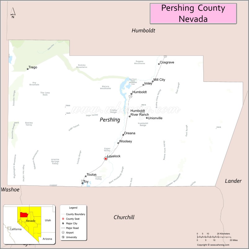
Map of Pershing County, Nevada
About Nye County Map, Nevada: The map showing the county boundary, county seat, major cities, highways, water bodies and neighbouring counties.
Related Nevada Links
Map of Pershing County, Nevada
Pershing County is a county located in the U.S. state of Nevada. It's county seat is Lovelock. As per 2020 census, the population of Pershing County is 6741 people and population density is square miles. According to the United States Census Bureau, the county has a total area of 6,009 sq mi (15,563 km2). Pershing County was established on 1919.
Pershing County Facts
| Continent | North America |
| Country | United States |
| State | Nevada |
| County Seat | Lovelock |
| Largest City/Town | Lovelock |
| Established | 1919 |
| Total Area | 6,037 sq mi (15,636 sq km) |
| Land Area | 6,032 sq mi (15,621 sq km) |
| Water Area | 5 sq mi (13 sq km) |
| Population | 6,650 (Census 2020) |
| Population Density | 1 person per sq mi |
| Time Zone | Pacific Time Zone (PT) |
| Major Highways | I-80, US-95, NV-399 |
| Major Rivers | Humboldt River |
| Neighboring Counties | Humboldt County, Lander County, Churchill County, Washoe County |
| Famous For | Burning Man (Black Rock Desert), Lovelock Prison, desert landscapes |
| Top Attractions | Black Rock Desert, Lovelock Cave, Rye Patch State Recreation Area, Burning Man site |
| Official Website | Official Website |
About Pershing County, Nevada
Pershing County is located in northwestern Nevada, in the United States, and was established in 1919. The county seat is Lovelock, which is also the largest city. The county lies in the Great Basin region and is known for its vast desert landscapes, the Black Rock Desert, and as the site of the annual Burning Man festival.
Cities and Towns in Pershing County, Nevada
| City/Town | Population (Census 2020) | Latitude & Longitude |
|---|---|---|
| Lovelock (county seat) | 1,800+ | 40.1800°N, 118.4700°W |
| Imlay (community) | 200+ | 40.6700°N, 118.1500°W |
| Unionville (historic town) | 20+ | 40.4500°N, 118.2000°W |
| Oreana (community) | 100+ | 40.1800°N, 118.2500°W |
Golf Courses in Pershing County, Nevada
| Golf Course | Location | Latitude & Longitude |
|---|---|---|
| Lovelock Golf Course | Lovelock | 40.1800°N, 118.4700°W |
| No other major courses in the county | — | — |
Roads and Highways in Pershing County, Nevada
Pershing County is connected by highways serving northwestern Nevada.
- I-80 – major east–west interstate across northern Nevada
- US-95 – north–south route through the western part of the county
- NV-399 – connects Lovelock to nearby areas
Neighboring Counties of Pershing County
- Humboldt County (north)
- Lander County (east)
- Churchill County (south)
- Washoe County (west)
Top Attractions in Pershing County, Nevada
The county offers desert landscapes, outdoor recreation, and unique events.
- Black Rock Desert – vast playa and site of Burning Man
- Lovelock Cave – archaeological site with ancient artifacts
- Rye Patch State Recreation Area – boating, fishing, and camping
- Burning Man site – annual arts and culture festival location
- Humboldt River – scenic views and outdoor activities
- Unionville Historic District – historic mining-era town
Distance from Pershing County to Nearby Cities
- Lovelock to Reno – 90 mi (145 km)
- Lovelock to Winnemucca – 80 mi (129 km)
- Lovelock to Elko – 200 mi (322 km)
- Lovelock to Las Vegas – 400 mi (644 km)
- Lovelock to Sacramento, CA – 200 mi (322 km)
FAQs about Pershing County
Pershing County is located in northwestern Nevada in the Great Basin region.
The population of Pershing County is 6,650 according to the 2020 Census.
Pershing County is known for the Black Rock Desert and the Burning Man festival.
Major highways include I-80, US-95, and NV-399.
Yes, Pershing County has a golf course such as Lovelock Golf Course.
- Churchill County Map
- Clark County Map
- Douglas County Map
- Elko County Map
- Esmeralda County Map
- Eureka County Map
- Humboldt County Map
- Lander County Map
- Lincoln County Map
- Lyon County Map
- Mineral County Map
- Nye County Map
- Pershing County Map
- Storey County Map
- Washoe County Map
- White Pine County Map
- Carson County Map
- Alabama Counties
- Alaska boroughs
- Arizona Counties
- Arkansas Counties
- California County Map
- Colorado Counties
- Connecticut Counties
- Delaware Counties
- Florida County Map
- Georgia County Map
- Hawaii Counties
- Idaho Counties
- Illinois Counties
- Indiana Counties
- Iowa Counties
- Kansas Counties
- Kentucky Counties
- Louisiana Counties
- Maine Counties
- Maryland Counties
- Massachusetts Counties
- Michigan County Map
- Minnesota Counties
- Mississippi Counties
- Missouri Counties
- Montana Counties
- Nebraska Counties
- Nevada Counties
- New York Counties
- New Hampshire Counties
- New Jersey Counties
- New Mexico Counties
- North Carolina Counties
- North Dakota Counties
- Ohio County Map
- Oklahoma Counties
- Oregon Counties
- Pennsylvania Counties
- Rhode Island Counties
- South Carolina Counties
- South Dakota Counties
- Map of Tennessee
- Texas County Map
- Utah Counties
- Vermont Counties
- Virginia Counties
- Washington Counties
- West Virginia Counties
- Wisconsin Counties
- Wyoming Counties