Written and Fact-checked by Mukesh Kumar | Updated On: May 05, 2026 | 06:50 ET
Map of Eureka County - Eureka County is a county located in the U.S. state of Nevada. Eureka County Map showing cities, highways, important places and water bodies. Get Where is Eureka County located in the map, major cities in Eureka county, population, areas, and places of interest.
Map of Humboldt County, Nevada
About Eureka County Map, Nevada: The map showing the county boundary, county seat, major cities, highways, water bodies and neighbouring counties.
Related Nevada Links
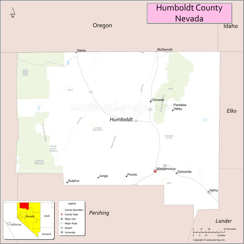
Map of Humboldt County, Nevada
Humboldt County is a county located in the U.S. state of Nevada. It's county seat is Winnemucca. As per 2020 census, the population of Humboldt County is 17648 people and population density is square miles. According to the United States Census Bureau, the county has a total area of 9,658 sq mi (25,014 km2). Humboldt County was established on 1861.
Humboldt County Facts
| Continent | North America |
| Country | United States |
| State | Nevada |
| County Seat | Winnemucca |
| Largest City/Town | Winnemucca |
| Established | 1861 |
| Total Area | 9,658 sq mi (25,015 sq km) |
| Land Area | 9,629 sq mi (24,944 sq km) |
| Water Area | 29 sq mi (75 sq km) |
| Population | 17,285 (Census 2020) |
| Population Density | 2 people per sq mi |
| Time Zone | Pacific Time Zone (PT) |
| Major Highways | I-80, US-95, NV-140, NV-290 |
| Major Rivers | Humboldt River |
| Neighboring Counties | Elko County, Lander County, Pershing County, Washoe County, Malheur County (OR), Harney County (OR) |
| Famous For | Mining, ranching, Basque culture, wide-open landscapes |
| Top Attractions | Humboldt Museum, Winnemucca Sand Dunes, Paradise Valley, Santa Rosa Range |
| Official Website | Official Website |
About Humboldt County, Nevada
Humboldt County is located in the northwestern part of Nevada, in the United States, and was established in 1861. The county seat is Winnemucca, which is also the largest city. The county lies in the Great Basin region and is known for its mining industry, ranching traditions, Basque heritage, and expansive desert and mountain landscapes.
Cities and Towns in Humboldt County, Nevada
| City/Town | Population (Census 2020) | Latitude & Longitude |
|---|---|---|
| Winnemucca (county seat) | 8,431 | 40.9730°N, 117.7357°W |
| Paradise Valley | 100+ | 41.4900°N, 117.5300°W |
| McDermitt (partly in Oregon) | 500+ | 42.0100°N, 117.7200°W |
| Orovada (community) | 200+ | 41.5500°N, 117.7800°W |
| Denio (community) | 100+ | 41.9800°N, 118.6400°W |
Golf Courses in Humboldt County, Nevada
| Golf Course | Location | Latitude & Longitude |
|---|---|---|
| Winnemucca Golf Course | Winnemucca | 40.9700°N, 117.7400°W |
| Denio Golf Course (small rural course) | Denio area | 41.9800°N, 118.6400°W |
Roads and Highways in Humboldt County, Nevada
Humboldt County is connected by highways serving northern Nevada and nearby states.
- I-80 – major east–west interstate across northern Nevada
- US-95 – north–south route connecting to Oregon and southern Nevada
- NV-140 – connects to Oregon and rural communities
- NV-290 – provides access to Paradise Valley
Neighboring Counties of Humboldt County
- Elko County (east)
- Lander County (south)
- Pershing County (southwest)
- Washoe County (west)
- Harney County, Oregon (northwest)
- Malheur County, Oregon (north)
Top Attractions in Humboldt County, Nevada
The county offers desert landscapes, historic sites, and outdoor recreation.
- Humboldt Museum – local history and exhibits
- Winnemucca Sand Dunes – off-roading and recreation
- Paradise Valley – scenic rural valley with historic charm
- Santa Rosa Range – hiking, camping, and wildlife viewing
- Humboldt River – fishing and scenic views
- Local Basque restaurants – cultural cuisine and traditions
Distance from Humboldt County to Nearby Cities
- Winnemucca to Reno – 165 mi (266 km)
- Winnemucca to Elko – 125 mi (201 km)
- Winnemucca to Boise, ID – 220 mi (354 km)
- Winnemucca to Las Vegas – 460 mi (740 km)
- Winnemucca to Sacramento, CA – 300 mi (483 km)
FAQs about Humboldt County
Humboldt County is located in northwestern Nevada in the Great Basin region.
The population of Humboldt County is 17,285 according to the 2020 Census.
Humboldt County is known for mining, ranching, and its Basque cultural heritage.
Major highways include I-80, US-95, NV-140, and NV-290.
Yes, Humboldt County has golf courses including Winnemucca Golf Course and Denio Golf Course.
- Churchill County Map
- Clark County Map
- Douglas County Map
- Elko County Map
- Esmeralda County Map
- Eureka County Map
- Humboldt County Map
- Lander County Map
- Lincoln County Map
- Lyon County Map
- Mineral County Map
- Nye County Map
- Pershing County Map
- Storey County Map
- Washoe County Map
- White Pine County Map
- Carson County Map
- Alabama Counties
- Alaska boroughs
- Arizona Counties
- Arkansas Counties
- California County Map
- Colorado Counties
- Connecticut Counties
- Delaware Counties
- Florida County Map
- Georgia County Map
- Hawaii Counties
- Idaho Counties
- Illinois Counties
- Indiana Counties
- Iowa Counties
- Kansas Counties
- Kentucky Counties
- Louisiana Counties
- Maine Counties
- Maryland Counties
- Massachusetts Counties
- Michigan County Map
- Minnesota Counties
- Mississippi Counties
- Missouri Counties
- Montana Counties
- Nebraska Counties
- Nevada Counties
- New York Counties
- New Hampshire Counties
- New Jersey Counties
- New Mexico Counties
- North Carolina Counties
- North Dakota Counties
- Ohio County Map
- Oklahoma Counties
- Oregon Counties
- Pennsylvania Counties
- Rhode Island Counties
- South Carolina Counties
- South Dakota Counties
- Map of Tennessee
- Texas County Map
- Utah Counties
- Vermont Counties
- Virginia Counties
- Washington Counties
- West Virginia Counties
- Wisconsin Counties
- Wyoming Counties