Written and Fact-checked by Mukesh Kumar | Updated On: May 05, 2026 | 06:50 ET
Map of Elko County - Elko County is a county located in the U.S. state of Nevada. Elko County Map showing cities, highways, important places and water bodies. Get Where is Elko County located in the map, major cities in Elko county, population, areas, and places of interest.
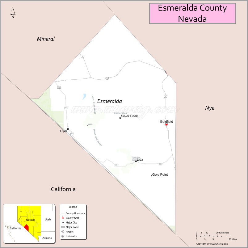
Map of Esmeralda County, Nevada
About Elko County Map, Nevada: The map showing the county boundary, county seat, major cities, highways, water bodies and neighbouring counties.
Related Nevada Links
Map of Esmeralda County, Nevada
Esmeralda County is a county located in the U.S. state of Nevada. It's county seat is Goldfield. As per 2020 census, the population of Esmeralda County is 743 people and population density is square miles. According to the United States Census Bureau, the county has a total area of 3,589 sq mi (9,295 km2). Esmeralda County was established on 1861.
Esmeralda County Facts
| Continent | North America |
| Country | United States |
| State | Nevada |
| County Seat | Goldfield |
| Largest City/Town | Goldfield |
| Established | 1861 |
| Total Area | 3,589 sq mi (9,296 sq km) |
| Land Area | 3,581 sq mi (9,275 sq km) |
| Water Area | 8 sq mi (21 sq km) |
| Population | 729 (Census 2020) |
| Population Density | 0.2 people per sq mi |
| Time Zone | Pacific Time Zone (PT) |
| Major Highways | US-95, NV-266 |
| Major Rivers | None (arid desert region) |
| Neighboring Counties | Nye County, Mineral County, Inyo County (CA), Mono County (CA) |
| Famous For | Historic mining towns, ghost towns, desert landscapes |
| Top Attractions | Goldfield Historic District, International Car Forest of the Last Church, Silver Peak, ghost towns |
| Official Website | Official Website |
About Esmeralda County, Nevada
Esmeralda County is located in the western part of Nevada, in the United States, and was established in 1861. The county seat is Goldfield, which is also the largest community. The county lies in a remote desert region along the California border and is known for its historic mining heritage, ghost towns, and vast open landscapes.
Cities and Towns in Esmeralda County, Nevada
| City/Town | Population (Census 2020) | Latitude & Longitude |
|---|---|---|
| Goldfield (county seat) | 200+ | 37.7100°N, 117.2400°W |
| Silver Peak | 100+ | 37.7700°N, 117.6400°W |
| Dyer (community) | 200+ | 37.7200°N, 118.0300°W |
| Lida (ghost town) | — | 37.4500°N, 117.5300°W |
| Gold Point (ghost town) | — | 37.3500°N, 117.6000°W |
Golf Courses in Esmeralda County, Nevada
| Golf Course | Location | Latitude & Longitude |
|---|---|---|
| No major golf courses in the county | — | — |
Roads and Highways in Esmeralda County, Nevada
Esmeralda County is connected by highways serving remote desert areas.
- US-95 – major north–south route through Nevada
- NV-266 – connects the county to California and surrounding regions
Neighboring Counties of Esmeralda County
- Nye County (north and east)
- Mineral County (northwest)
- Inyo County, California (southwest)
- Mono County, California (west)
Top Attractions in Esmeralda County, Nevada
The county offers historic sites, desert scenery, and unique attractions.
- Goldfield Historic District – preserved mining-era buildings
- International Car Forest of the Last Church – artistic installation of painted cars
- Silver Peak – historic mining town
- Ghost towns – Lida, Gold Point, and others
- Desert landscapes – wide-open spaces and scenic views
- Star gazing – dark skies ideal for astronomy
Distance from Esmeralda County to Nearby Cities
- Goldfield to Tonopah – 25 mi (40 km)
- Goldfield to Las Vegas – 180 mi (290 km)
- Goldfield to Reno – 220 mi (354 km)
- Goldfield to Bishop, CA – 120 mi (193 km)
- Goldfield to Los Angeles, CA – 300 mi (483 km)
FAQs about Esmeralda County
Esmeralda County is located in western Nevada along the California border.
The population of Esmeralda County is 729 according to the 2020 Census.
Esmeralda County is known for its historic mining towns, ghost towns, and desert landscapes.
Major highways include US-95 and NV-266.
No, there are no major golf courses in Esmeralda County.
- Churchill County Map
- Clark County Map
- Douglas County Map
- Elko County Map
- Esmeralda County Map
- Eureka County Map
- Humboldt County Map
- Lander County Map
- Lincoln County Map
- Lyon County Map
- Mineral County Map
- Nye County Map
- Pershing County Map
- Storey County Map
- Washoe County Map
- White Pine County Map
- Carson County Map
- Alabama Counties
- Alaska boroughs
- Arizona Counties
- Arkansas Counties
- California County Map
- Colorado Counties
- Connecticut Counties
- Delaware Counties
- Florida County Map
- Georgia County Map
- Hawaii Counties
- Idaho Counties
- Illinois Counties
- Indiana Counties
- Iowa Counties
- Kansas Counties
- Kentucky Counties
- Louisiana Counties
- Maine Counties
- Maryland Counties
- Massachusetts Counties
- Michigan County Map
- Minnesota Counties
- Mississippi Counties
- Missouri Counties
- Montana Counties
- Nebraska Counties
- Nevada Counties
- New York Counties
- New Hampshire Counties
- New Jersey Counties
- New Mexico Counties
- North Carolina Counties
- North Dakota Counties
- Ohio County Map
- Oklahoma Counties
- Oregon Counties
- Pennsylvania Counties
- Rhode Island Counties
- South Carolina Counties
- South Dakota Counties
- Map of Tennessee
- Texas County Map
- Utah Counties
- Vermont Counties
- Virginia Counties
- Washington Counties
- West Virginia Counties
- Wisconsin Counties
- Wyoming Counties