Written and Fact-checked by Mukesh Kumar | Updated On: May 05, 2026 | 06:50 ET
Map of Lander County - Lander County is a county located in the U.S. state of Nevada. Lander County Map showing cities, highways, important places and water bodies. Get Where is Lander County located in the map, major cities in Lander county, population, areas, and places of interest.
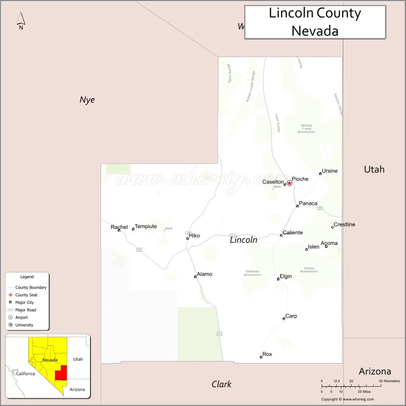
Map of Lincoln County, Nevada
About Lander County Map, Nevada: The map showing the county boundary, county seat, major cities, highways, water bodies and neighbouring counties.
Related Nevada Links
Map of Lincoln County, Nevada
Lincoln County is a county located in the U.S. state of Nevada. It's county seat is Pioche. As per 2020 census, the population of Lincoln County is 4525 people and population density is square miles. According to the United States Census Bureau, the county has a total area of 10,635 sq mi (27,545 km2). Lincoln County was established on 1866.
Lincoln County Facts
| Continent | North America |
| Country | United States |
| State | Nevada |
| County Seat | Pioche |
| Largest City/Town | Caliente |
| Established | 1866 |
| Total Area | 10,637 sq mi (27,550 sq km) |
| Land Area | 10,634 sq mi (27,542 sq km) |
| Water Area | 3 sq mi (8 sq km) |
| Population | 4,499 (Census 2020) |
| Population Density | 0.4 people per sq mi |
| Time Zone | Pacific Time Zone (PT) |
| Major Highways | US-93, US-93 Alternate, NV-318, NV-319 |
| Major Rivers | Meadow Valley Wash |
| Neighboring Counties | White Pine County, Nye County, Clark County, Mohave County (AZ), Iron County (UT), Washington County (UT) |
| Famous For | Extraterrestrial Highway (Area 51 region), historic mining towns |
| Top Attractions | Cathedral Gorge State Park, Kershaw-Ryan State Park, Pioche Historic District, Extraterrestrial Highway |
| Official Website | Official Website |
About Lincoln County, Nevada
Lincoln County is located in the southeastern part of Nevada, in the United States, and was established in 1866. The county seat is Pioche, while Caliente is the largest town. The county lies in a remote desert region and is known for its historic mining heritage, scenic state parks, and the famous Extraterrestrial Highway near Area 51.
Cities and Towns in Lincoln County, Nevada
| City/Town | Population (Census 2020) | Latitude & Longitude |
|---|---|---|
| Caliente | 1,000+ | 37.6100°N, 114.5100°W |
| Pioche (county seat) | 900+ | 37.9300°N, 114.4500°W |
| Panaca | 1,000+ | 37.7900°N, 114.3900°W |
| Alamo | 1,100+ | 37.3700°N, 115.1600°W |
| Rachel | 100+ | 37.6400°N, 115.7500°W |
Golf Courses in Lincoln County, Nevada
| Golf Course | Location | Latitude & Longitude |
|---|---|---|
| Caliente Golf Course | Caliente | 37.6100°N, 114.5100°W |
| No other major courses in the county | — | — |
Roads and Highways in Lincoln County, Nevada
Lincoln County is connected by highways serving southeastern Nevada and surrounding regions.
- US-93 – major north–south route through the county
- US-93 Alternate – connects to Ely and nearby areas
- NV-318 – scenic route through rural valleys
- NV-319 – connects Panaca to Utah
Neighboring Counties of Lincoln County
- White Pine County (north)
- Nye County (west)
- Clark County (south)
- Mohave County, Arizona (southeast)
- Iron County, Utah (east)
- Washington County, Utah (south)
Top Attractions in Lincoln County, Nevada
The county offers scenic parks, historic sites, and unique desert experiences.
- Cathedral Gorge State Park – unique clay formations and hiking trails
- Kershaw-Ryan State Park – canyon landscapes and camping
- Pioche Historic District – preserved mining-era town
- Extraterrestrial Highway – famous route near Area 51
- Echo Canyon State Park – fishing and camping
- Wide-open desert landscapes – ideal for exploration and stargazing
Distance from Lincoln County to Nearby Cities
- Caliente to Las Vegas – 150 mi (241 km)
- Caliente to Ely – 120 mi (193 km)
- Caliente to St. George, UT – 110 mi (177 km)
- Caliente to Salt Lake City, UT – 280 mi (451 km)
- Caliente to Reno – 450 mi (724 km)
FAQs about Lincoln County
Lincoln County is located in southeastern Nevada near the borders of Utah and Arizona.
The population of Lincoln County is 4,499 according to the 2020 Census.
Lincoln County is known for the Extraterrestrial Highway, historic mining towns, and scenic state parks.
Major highways include US-93, US-93 Alternate, NV-318, and NV-319.
Yes, Lincoln County has a golf course such as Caliente Golf Course.
- Churchill County Map
- Clark County Map
- Douglas County Map
- Elko County Map
- Esmeralda County Map
- Eureka County Map
- Humboldt County Map
- Lander County Map
- Lincoln County Map
- Lyon County Map
- Mineral County Map
- Nye County Map
- Pershing County Map
- Storey County Map
- Washoe County Map
- White Pine County Map
- Carson County Map
- Alabama Counties
- Alaska boroughs
- Arizona Counties
- Arkansas Counties
- California County Map
- Colorado Counties
- Connecticut Counties
- Delaware Counties
- Florida County Map
- Georgia County Map
- Hawaii Counties
- Idaho Counties
- Illinois Counties
- Indiana Counties
- Iowa Counties
- Kansas Counties
- Kentucky Counties
- Louisiana Counties
- Maine Counties
- Maryland Counties
- Massachusetts Counties
- Michigan County Map
- Minnesota Counties
- Mississippi Counties
- Missouri Counties
- Montana Counties
- Nebraska Counties
- Nevada Counties
- New York Counties
- New Hampshire Counties
- New Jersey Counties
- New Mexico Counties
- North Carolina Counties
- North Dakota Counties
- Ohio County Map
- Oklahoma Counties
- Oregon Counties
- Pennsylvania Counties
- Rhode Island Counties
- South Carolina Counties
- South Dakota Counties
- Map of Tennessee
- Texas County Map
- Utah Counties
- Vermont Counties
- Virginia Counties
- Washington Counties
- West Virginia Counties
- Wisconsin Counties
- Wyoming Counties