Written and Fact-checked by Mukesh Kumar | Updated On: May 05, 2026 | 06:50 ET
Map of Clark County - Clark County is a county located in the U.S. state of Nevada. Clark County Map showing cities, highways, important places and water bodies. Get Where is Clark County located in the map, major cities in Clark county, population, areas, and places of interest.
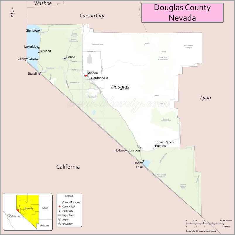
Map of Douglas County, Nevada
About Clark County Map, Nevada: The map showing the county boundary, county seat, major cities, highways, water bodies and neighbouring counties.
Related Nevada Links
Map of Douglas County, Nevada
Douglas County is a county located in the U.S. state of Nevada. It's county seat is Minden. As per 2020 census, the population of Douglas County is 49870 people and population density is square miles. According to the United States Census Bureau, the county has a total area of 710 sq mi (1,839 km2). Douglas County was established on 1861.
Douglas County Facts
| Continent | North America |
| Country | United States |
| State | Nevada |
| County Seat | Minden |
| Largest City/Town | Gardnerville |
| Established | 1861 |
| Total Area | 738 sq mi (1,911 sq km) |
| Land Area | 710 sq mi (1,839 sq km) |
| Water Area | 28 sq mi (72 sq km) |
| Population | 49,488 (Census 2020) |
| Population Density | 70 people per sq mi |
| Time Zone | Pacific Time Zone (PT) |
| Major Highways | US-395, US-50, NV-88 |
| Major Rivers | Carson River |
| Neighboring Counties | Carson City, Lyon County, Mineral County, Alpine County (CA), El Dorado County (CA) |
| Famous For | Lake Tahoe, Carson Valley, outdoor recreation |
| Top Attractions | Lake Tahoe (east shore), Heavenly Mountain Resort, Genoa Historic District, Dangberg Home Ranch |
| Official Website | Official Website |
About Douglas County, Nevada
Douglas County is located in the western part of Nevada, in the United States, and was established in 1861. The county seat is Minden, while Gardnerville is the largest community. The county lies along the eastern slope of the Sierra Nevada mountains and includes part of Lake Tahoe, making it a popular destination for outdoor recreation, scenic beauty, and tourism.
Cities and Towns in Douglas County, Nevada
| City/Town | Population (Census 2020) | Latitude & Longitude |
|---|---|---|
| Gardnerville | 6,000+ | 38.9400°N, 119.7500°W |
| Minden (county seat) | 3,500+ | 38.9600°N, 119.7600°W |
| Genoa | 1,300 | 39.0000°N, 119.8400°W |
| Stateline | 1,000+ | 38.9700°N, 119.9400°W |
| Topaz Ranch Estates | 1,500+ | 38.7000°N, 119.5000°W |
| Johnson Lane (CDP) | 6,000+ | 38.9400°N, 119.7100°W |
Golf Courses in Douglas County, Nevada
| Golf Course | Location | Latitude & Longitude |
|---|---|---|
| Genoa Lakes Golf Club | Genoa | 39.0000°N, 119.8400°W |
| Carson Valley Golf Course | Gardnerville | 38.9400°N, 119.7500°W |
Roads and Highways in Douglas County, Nevada
Douglas County is connected by highways serving western Nevada and the Lake Tahoe region.
- US-395 – major north–south route through the Carson Valley
- US-50 – connects the county to Lake Tahoe and Carson City
- NV-88 – scenic route connecting to California
Neighboring Counties of Douglas County
- Carson City (north)
- Lyon County (east)
- Mineral County (southeast)
- Alpine County, California (southwest)
- El Dorado County, California (west)
Top Attractions in Douglas County, Nevada
The county offers mountain scenery, historic sites, and outdoor recreation.
- Lake Tahoe (east shore) – beaches, boating, and scenic views
- Heavenly Mountain Resort – skiing and mountain activities
- Genoa Historic District – Nevada’s oldest settlement
- Dangberg Home Ranch Historic Park – historic ranch and museum
- Carson Valley – scenic landscapes and wildlife viewing
- Hot springs and trails – outdoor recreation opportunities
Distance from Douglas County to Nearby Cities
- Minden to Carson City – 15 mi (24 km)
- Minden to Reno – 45 mi (72 km)
- Minden to Sacramento, CA – 120 mi (193 km)
- Minden to San Francisco, CA – 200 mi (322 km)
- Minden to Las Vegas – 450 mi (724 km)
FAQs about Douglas County
Douglas County is located in western Nevada along the eastern slope of the Sierra Nevada mountains.
The population of Douglas County is 49,488 according to the 2020 Census.
Douglas County is known for Lake Tahoe, Carson Valley, and outdoor recreation.
Major highways include US-395, US-50, and NV-88.
Yes, Douglas County has golf courses including Genoa Lakes Golf Club and Carson Valley Golf Course.
- Churchill County Map
- Clark County Map
- Douglas County Map
- Elko County Map
- Esmeralda County Map
- Eureka County Map
- Humboldt County Map
- Lander County Map
- Lincoln County Map
- Lyon County Map
- Mineral County Map
- Nye County Map
- Pershing County Map
- Storey County Map
- Washoe County Map
- White Pine County Map
- Carson County Map
- Alabama Counties
- Alaska boroughs
- Arizona Counties
- Arkansas Counties
- California County Map
- Colorado Counties
- Connecticut Counties
- Delaware Counties
- Florida County Map
- Georgia County Map
- Hawaii Counties
- Idaho Counties
- Illinois Counties
- Indiana Counties
- Iowa Counties
- Kansas Counties
- Kentucky Counties
- Louisiana Counties
- Maine Counties
- Maryland Counties
- Massachusetts Counties
- Michigan County Map
- Minnesota Counties
- Mississippi Counties
- Missouri Counties
- Montana Counties
- Nebraska Counties
- Nevada Counties
- New York Counties
- New Hampshire Counties
- New Jersey Counties
- New Mexico Counties
- North Carolina Counties
- North Dakota Counties
- Ohio County Map
- Oklahoma Counties
- Oregon Counties
- Pennsylvania Counties
- Rhode Island Counties
- South Carolina Counties
- South Dakota Counties
- Map of Tennessee
- Texas County Map
- Utah Counties
- Vermont Counties
- Virginia Counties
- Washington Counties
- West Virginia Counties
- Wisconsin Counties
- Wyoming Counties