Written and Fact-checked by Mukesh Kumar | Updated On: May 05, 2026 | 06:50 ET
Map of Mineral County - Mineral County is a county located in the U.S. state of Nevada. Mineral County Map showing cities, highways, important places and water bodies. Get Where is Mineral County located in the map, major cities in Mineral county, population, areas, and places of interest.
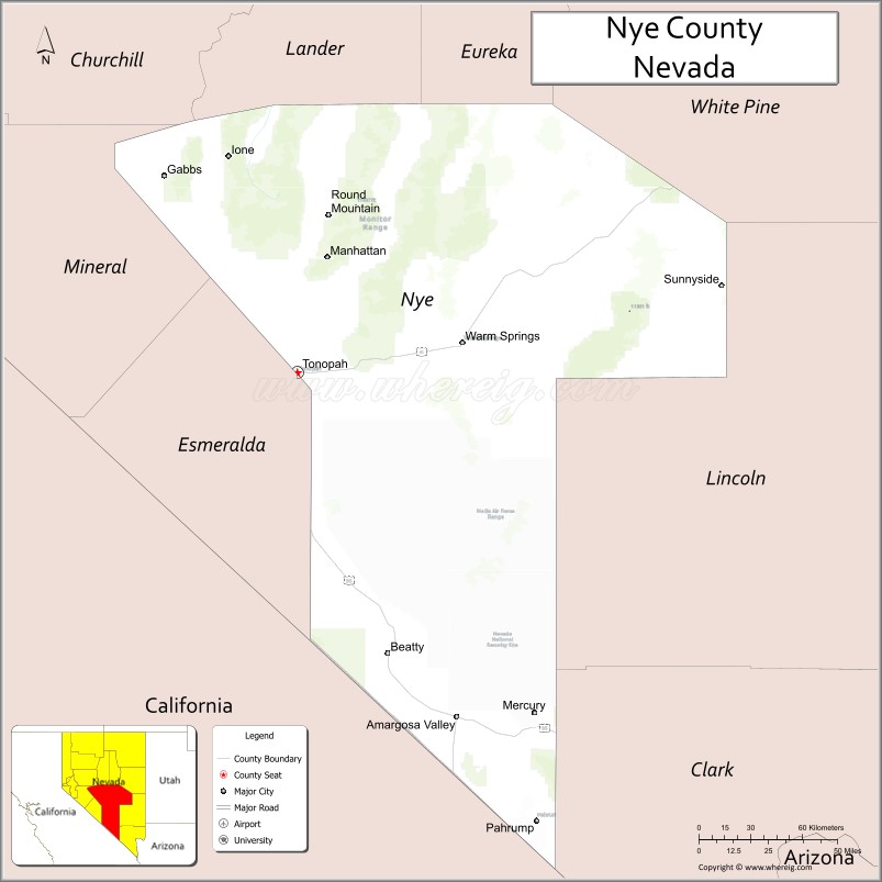
Map of Nye County, Nevada
About Mineral County Map, Nevada: The map showing the county boundary, county seat, major cities, highways, water bodies and neighbouring counties.
Related Nevada Links
Map of Nye County, Nevada
Nye County is a county located in the U.S. state of Nevada. It's county seat is Tonopah. As per 2020 census, the population of Nye County is 53450 people and population density is square miles. According to the United States Census Bureau, the county has a total area of 18,147 sq mi (47,001 km2). Nye County was established on 1864.
Nye County Facts
| Continent | North America |
| Country | United States |
| State | Nevada |
| County Seat | Tonopah |
| Largest City/Town | Pahrump |
| Established | 1864 |
| Total Area | 18,147 sq mi (46,999 sq km) |
| Land Area | 18,146 sq mi (46,997 sq km) |
| Water Area | 1 sq mi (2 sq km) |
| Population | 53,234 (Census 2020) |
| Population Density | 3 people per sq mi |
| Time Zone | Pacific Time Zone (PT) |
| Major Highways | US-95, US-6, NV-160, NV-373 |
| Major Rivers | Amargosa River (intermittent) |
| Neighboring Counties | Esmeralda County, Mineral County, Lander County, Eureka County, Lincoln County, Clark County, Inyo County (CA) |
| Famous For | Area 51 region, Death Valley proximity, desert landscapes |
| Top Attractions | Tonopah Historic Mining Park, Rhyolite Ghost Town, Ash Meadows National Wildlife Refuge, Extraterrestrial Highway |
| Official Website | Official Website |
About Nye County, Nevada
Nye County is located in the central and southern parts of Nevada, in the United States, and was established in 1864. The county seat is Tonopah, while Pahrump is the largest town. The county lies in the Great Basin and Mojave Desert regions and is one of the largest counties in the United States by area, known for its mining history, proximity to Area 51, and vast desert landscapes.
Cities and Towns in Nye County, Nevada
| City/Town | Population (Census 2020) | Latitude & Longitude |
|---|---|---|
| Pahrump | 44,738 | 36.2083°N, 115.9839°W |
| Tonopah (county seat) | 2,500+ | 38.0700°N, 117.2300°W |
| Amargosa Valley | 1,200+ | 36.6400°N, 116.4000°W |
| Beatty | 1,000+ | 36.9100°N, 116.7500°W |
| Round Mountain | 1,500+ | 38.7200°N, 117.0800°W |
Golf Courses in Nye County, Nevada
| Golf Course | Location | Latitude & Longitude |
|---|---|---|
| Mountain Falls Golf Club | Pahrump | 36.2100°N, 115.9800°W |
| Lake View Executive Golf Course | Pahrump | 36.2100°N, 115.9700°W |
Roads and Highways in Nye County, Nevada
Nye County is connected by highways serving central and southern Nevada.
- US-95 – major north–south route through the county
- US-6 – crosses the northern part of the county
- NV-160 – connects Pahrump to Las Vegas
- NV-373 – connects Amargosa Valley to California
Neighboring Counties of Nye County
- Esmeralda County (west)
- Mineral County (northwest)
- Lander County (north)
- Eureka County (north)
- Lincoln County (east)
- Clark County (south)
- Inyo County, California (west)
Top Attractions in Nye County, Nevada
The county offers historic sites, desert scenery, and unique attractions.
- Tonopah Historic Mining Park – mining history exhibits
- Rhyolite Ghost Town – abandoned town near Death Valley
- Ash Meadows National Wildlife Refuge – rare desert ecosystems
- Extraterrestrial Highway – famous route near Area 51
- Goldfield and Tonopah Railway remnants – historic rail sites
- Desert landscapes – stargazing and outdoor exploration
Distance from Nye County to Nearby Cities
- Pahrump to Las Vegas – 60 mi (97 km)
- Tonopah to Reno – 230 mi (370 km)
- Pahrump to Los Angeles, CA – 230 mi (370 km)
- Tonopah to Las Vegas – 210 mi (338 km)
- Beatty to Death Valley, CA – 40 mi (64 km)
FAQs about Nye County
Nye County is located in central and southern Nevada spanning the Great Basin and Mojave Desert regions.
The population of Nye County is 53,234 according to the 2020 Census.
Nye County is known for Area 51, desert landscapes, and its mining history.
Major highways include US-95, US-6, NV-160, and NV-373.
Yes, Nye County has golf courses including Mountain Falls Golf Club and Lake View Executive Golf Course.
- Churchill County Map
- Clark County Map
- Douglas County Map
- Elko County Map
- Esmeralda County Map
- Eureka County Map
- Humboldt County Map
- Lander County Map
- Lincoln County Map
- Lyon County Map
- Mineral County Map
- Nye County Map
- Pershing County Map
- Storey County Map
- Washoe County Map
- White Pine County Map
- Carson County Map
- Alabama Counties
- Alaska boroughs
- Arizona Counties
- Arkansas Counties
- California County Map
- Colorado Counties
- Connecticut Counties
- Delaware Counties
- Florida County Map
- Georgia County Map
- Hawaii Counties
- Idaho Counties
- Illinois Counties
- Indiana Counties
- Iowa Counties
- Kansas Counties
- Kentucky Counties
- Louisiana Counties
- Maine Counties
- Maryland Counties
- Massachusetts Counties
- Michigan County Map
- Minnesota Counties
- Mississippi Counties
- Missouri Counties
- Montana Counties
- Nebraska Counties
- Nevada Counties
- New York Counties
- New Hampshire Counties
- New Jersey Counties
- New Mexico Counties
- North Carolina Counties
- North Dakota Counties
- Ohio County Map
- Oklahoma Counties
- Oregon Counties
- Pennsylvania Counties
- Rhode Island Counties
- South Carolina Counties
- South Dakota Counties
- Map of Tennessee
- Texas County Map
- Utah Counties
- Vermont Counties
- Virginia Counties
- Washington Counties
- West Virginia Counties
- Wisconsin Counties
- Wyoming Counties