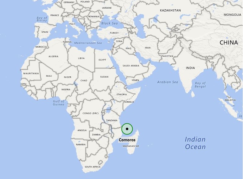
Comoros location map shows that Comoros is located in the Indian Ocean at off coast of Eastern Africa. Comoros map shows the exact position of Comoros i.e. it is located in the northern side of Mozambique Channel and between Madagascar and Mozambique. Other countries nearby Comoros are Seychelles (an island country in the India Ocean) in the northeast and Tanzania (eastern African country) in the northwest. The capital city of Comoros is Moroni.
In terms of area, Comoros is only the third-smallest African country. However, the small island country comprises of four islands namely Grande Comore or Ngazidja, Mohéli or Mwali, Anjouan or Nzwani, and southeastermost Mayotte or Maore; besides, some of the smaller islands are also there. Mayotte is French territory in the region.
The government type of the country is a federal presidential republic, in which the President of the Comoros is head of state as well as head of the government. There is also multi party system in the country. Surprisingly, Comoros is only state who is member of all international organization in the region including African Union, Francophonie, Organisation of the Islamic Conference, Arab League and Indian Ocean Commission.
Country’s economy is largely depends upon agriculture, including fishing, hunting, and forestry.
| Country | Comoros |
| Continent | Africa |
| Where is Located | Comoros is a country located in the Eastern Africa |
| Coordinates | 11°41'S43°16'E |
| Capital | Moroni |
| Largest City | Moroni |
| Neighboring Countries | None |
| Administrative divisions | 3 islands and 4 municipalities |
| Area | 863 Sq Miles |
| Population | 717,503 (2012) |
| Official Language | Comorian, Arabic, French |
| Currency | Comorian franc (KMF) |
| ISO Alpha-2 Code | KM |
| ISO Alpha-3 Code | COM |
| ISO Numeric Code | 174 |
| GDP | $873 million 2012 estimate |
| Calling code | 269 |
| Time Zone | EAT (UTC+3) |
| Internet TLD | .km |
- Where is Algeria
- Where is Angola
- Where is Benin
- Where is Botswana
- Where is Burkina Faso
- Where is Burundi
- Where is Cameroon
- Where is Canary Islands
- Where is Cape Verde
- Central African Republic
- Where is Ceuta
- Where is Chad
- Where is Cote d'Ivoire
- Where is Congo
- Where is Djibouti
- Where is Egypt
- Equatorial Guinea
- Where is Eritrea
- Where is Ethiopia
- Where is Gabon
- Where is Gambia
- Where is Ghana
- Where is Guinea
- Guinea Bissau
- Where is Kenya
- Where is Lesotho
- Where is Liberia
- Where is Libya
- Where is Madagascar
- Where is Madeira
- Where is Malawi
- Where is Mali
- Where is Mauritania
- Where is Mauritius
- Where is Mayotte
- Where is Morocco
- Where is Mozambique
- Where is Namibia
- Where is Niger
- Where is Nigeria
- Where is Congo
- Where is Reunion
- Where is Rwanda
- Where is Saint Helena
- Where is Sao Tome
- Where is Senegal
- Where is Seychelles
- Where is Sierra Leone
- Where is South Africa
- Where is Sudan
- Where is Swaziland
- Where is Tanzania
- Where is Togo
- Where is Tunisia
- Where is Uganda
- Where is Western Sahara
- Where is Zambia
- Where is Zimbabwe


