
Where is Beaverton Located? - Beaverton is a city located in the Washington County of Oregon, United States. Beaverton lies between 45.47503 Degrees North latitudes and -122.805 Degrees West longitudes.
Location Map of Beaverton, Oregon
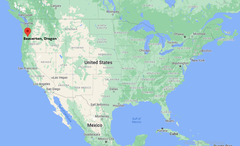
Beaverton Map, Oregon, USA
Where is Beaverton?: The Google Map showing the location of Beaverton in the U.S. state of Oregon.
Where is Beaverton Located?
Beaverton is a city located in the Washington County of Oregon, United States. Beaverton lies at approximately 45.47503 Degrees North latitude and -122.805 Degrees West longitude. According to the 2020 U.S. Census, the population of Beaverton city is 97,494 people and the city has a total area of 19.583 sq mi. The city has numerous parks and recreational facilities.
Most Viewed US Maps
| USA Sttae Map | USA Region Map | USA Road Map |
| USA County Map | Where is USA in World Map? | US ZIP Code Map |
| USA Time Zones Map | US State and Capitals Map | USA Physical Map |
Find 4,400+ U.S. Cities by State - Explore Their Locations and Get Detailed Information
Beaverton, Oregon Quick Facts
| Fact | Details |
|---|---|
| City | Beaverton |
| County | Washington County |
| State | Oregon |
| State Capital | Salem |
| Country | United States |
| US Region | West |
| Latitude | 45.47503 N |
| Longitude | -122.805 W |
| Elevation | 189 ft (58 m) |
| Land Area | 19.7 sq mi |
| Water Area | 0.1 sq mi |
| Total Area | 19.583 sq mi |
| Population (Census 2020) | 97,494 |
| Population Density | Approximately 4,949 per sq mi |
| ZIP Codes | 97003, 97005, 97006, 97007, 97008, 97075, 97076, 97225 |
| Area Code | 503, 971 |
| Time Zone Standard | Pacific Standard Time (PST, UTC-8) |
| Time Zone Daylight | Pacific Daylight Time (PDT, UTC-7) |
| Currency | United States Dollar (USD) |
| FIPS Code | 41-05350 |
| Congressional District | Oregon's 6th Congressional District |
Nearby Cities to Beaverton, Oregon
- Tigard, Oregon - 5 mi South
- Hillsboro, Oregon - 8 mi West
- Portland, Oregon - 9 mi East
- Aloha, Oregon - 4 mi West
- King City, Oregon - 7 mi South
- Lake Oswego, Oregon - 11 mi Southeast
- Tualatin, Oregon - 12 mi South
- Forest Grove, Oregon - 22 mi West
- Oregon City, Oregon - 22 mi Southeast
- Vancouver, Washington - 18 mi Northeast
Beaverton, Oregon Climate and Weather Overview
| Month | Avg High (°F) | Avg Low (°F) | Avg Rainfall (in) |
|---|---|---|---|
| January | 47 | 36 | 5.8 |
| April | 61 | 42 | 3.1 |
| July | 82 | 57 | 0.6 |
| October | 66 | 47 | 2.7 |
| Annual | 64 | 46 | 37.5 |
| Climate Attribute | Details |
|---|---|
| Climate Classification | Warm-Summer Mediterranean (Köppen Csb) |
| Annual Rainfall | Approximately 37.5 inches |
| Annual Sunshine Days | About 154 days |
| Hurricane/Tornado Risk | Low - Occasional winter storms and wind events |
| Snowfall | Approximately 3 inches annually |
Driving Distances from Beaverton, Oregon
| City | State | Distance (mi) | Approx. Drive Time |
|---|---|---|---|
| Aloha | Oregon | 4 | 10 min |
| Tigard | Oregon | 5 | 12 min |
| Hillsboro | Oregon | 8 | 15 min |
| Portland | Oregon | 9 | 20 min |
| Lake Oswego | Oregon | 11 | 20 min |
| Tualatin | Oregon | 12 | 22 min |
| Vancouver | Washington | 18 | 30 min |
| Forest Grove | Oregon | 22 | 30 min |
| Oregon City | Oregon | 22 | 35 min |
| Salem | Oregon | 48 | 55 min |
Transportation and Connectivity in Beaverton, Oregon
| Transportation | Details |
|---|---|
| Airport Name | Portland International Airport |
| IATA Code | PDX |
| Port | Port of Portland (nearby) |
| Major Highways | U.S. Route 26, Oregon Route 8, Oregon Route 217, Interstate 5 (nearby) |
| Train/Amtrak Service | Amtrak service available at Portland Union Station |
| Local Bus/Transit Service | TriMet buses and MAX Light Rail |
- U.S. Route 26 - Main east-west highway connecting Beaverton with Portland and the Oregon Coast.
- Oregon Route 217 - Connects Beaverton with Tigard, Interstate 5 and the Portland metropolitan area.
- Oregon Route 8 - Links downtown Beaverton with Hillsboro and surrounding Washington County communities.
- TriMet MAX Blue and Red Lines - Provide convenient light rail service between Beaverton, downtown Portland and Portland International Airport.
Key Landmarks and Places to Visit in Beaverton, Oregon
| Landmark | Type |
|---|---|
| Tualatin Hills Nature Park | Nature Park |
| Cooper Mountain Nature Park | Nature Park |
| The Round | Mixed-Use Landmark |
| Patricia Reser Center for the Arts | Performing Arts Center |
| Jenkins Estate | Historic Estate |
| Cedar Hills Crossing | Shopping Center |
| Howard M. Terpenning Recreation Complex | Recreation Center |
| Nike World Headquarters | Corporate Campus |
| THPRD HMT Complex | Sports Complex |
| Fanno Creek Greenway Trail | Multi-Use Trail |
Colleges and Universities in Beaverton, Oregon
| Institution | Type | Level | Notable For |
|---|---|---|---|
| Oregon State University - Portland Center | Public | University | Graduate and professional programs |
| Portland Community College - Rock Creek Campus | Public | Community College | Career and transfer education |
| Pacific University - Hillsboro Campus | Private | University | Health professions |
| University of Portland | Private | University | Business and engineering |
| Portland State University | Public | University | Urban research and sustainability |
| George Fox University | Private | University | Liberal arts and business |
Waterbodies in Beaverton, Oregon
Fanno Creek, Beaverton Creek, Tualatin River, Rock Creek, Cedar Mill Creek, Dawson Creek, Bethany Lake, Commonwealth Lake, Henry Hagg Lake, Willamette River.
Golf Courses in Beaverton, Oregon
RedTail Golf Center, Meriwether National Golf Club, Rock Creek Country Club, Reserve Vineyards and Golf Club, The Oregon Golf Club, Forest Hills Golf Course, Pumpkin Ridge Golf Club, Eastmoreland Golf Course.
Beaverton, Oregon - Key Historical Facts
- Beaverton began as a farming community in the mid-nineteenth century and was officially incorporated in 1893.
- The city's early economy was built on agriculture, with farmers producing hops, berries, onions and dairy products for the Portland market.
- Improved highway and rail connections encouraged suburban development after World War II, making Beaverton one of the fastest-growing communities in Oregon.
- Nike established its world headquarters near Beaverton in the 1960s, helping transform the city into a major center for sportswear, technology and innovation.
- The expansion of TriMet's MAX Light Rail strengthened Beaverton's role as an important transportation hub within the Portland metropolitan area.
- Today, Beaverton is recognized for its diverse population, thriving technology sector, extensive parks and high quality of life.
References
Oregon More Maps & Info
- Where is Albany
- Where is Aloha
- Where is Altamont
- Where is Ashland
- Where is Beaverton
- Where is Bend
- Where is Bethany
- Where is Canby
- Where is Cedar Mill
- Where is Central Point
- Where is Coos Bay
- Where is Corvallis
- Where is Eugene
- Where is Forest Grove
- Where is Four Corners
- Where is Grants Pass
- Where is Gresham
- Where is Happy Valley
- Where is Hayesville
- Where is Hermiston
- Where is Hillsboro
- Where is Keizer
- Where is Klamath Falls
- Where is La Grande
- Where is Lake Oswego
- Where is Lebanon
- Where is McMinnville
- Where is Medford
- Where is Milwaukie
- Where is Newberg
- Where is Oak Grove
- Where is Oatfield
- Where is Oregon City
- Where is Pendleton
- Where is Redmond
- Where is Roseburg
- Where is Sandy
- Where is Sherwood
- Where is St. Helens
- Where is The Dalles
- Where is Tigard
- Where is Troutdale
- Where is Tualatin
- Where is West Linn
- Where is Wilsonville
- Where is Woodburn