
Where is Grants Pass Located? - Grants Pass is a city located in the Josephine County of Oregon, United States. Grants Pass lies between 47.7735899 Degrees North latitudes and 97.109805 Degrees West longitudes.
Location Map of Grants Pass, Oregon
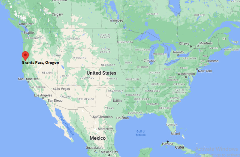
Grants Pass Map, Oregon, USA
Where is Grants Pass?: The Google Map showing the location of Grants Pass in the U.S. state of Oregon.
Where is Grants Pass Located?
Grants Pass is a city located in the Josephine County of Oregon, United States. Grants Pass lies between 47.7735899 Degrees North latitudes and 97.109805 Degrees West longitudes. According to 2020 U.S.census, the population of Grants Pass city is 39189 people and the city has a total area of 11.52 sq mi. The city has numerous parks and recreational facilities.
Most Viewed US Maps
| USA Sttae Map | USA Region Map | USA Road Map |
| USA County Map | Where is USA in World Map? | US ZIP Code Map |
| USA Time Zones Map | US State and Capitals Map | USA Physical Map |
Find 4,400+ U.S. Cities by State - Explore Their Locations and Get Detailed Information
Grants Pass, Oregon Quick Facts
| Property | Information |
|---|---|
| City | Grants Pass |
| County | Josephine County |
| State | Oregon |
| State Capital | Salem |
| US Region | Western United States |
| Latitude | 42.4390°N |
| Longitude | 123.3284°W |
| Elevation | 950 ft (290 m) |
| Land Area | 11.51 sq mi |
| Water Area | 0.09 sq mi |
| Total Area | 11.60 sq mi |
| Population (latest Census year) | 39,189 (Census 2020) |
| Population Density (per sq mi) | Approximately 3,405 |
| ZIP Codes | 97526, 97527 |
| Area Code | 541 |
| Time Zone Standard | Pacific Standard Time (PST, UTC−8) |
| Time Zone Daylight | Pacific Daylight Time (PDT, UTC−7) |
| Currency | United States Dollar (USD) |
| FIPS Code | 41-30550 |
| Congressional District | Oregon's 2nd Congressional District |
Nearby Cities to Grants Pass, Oregon
- Merlin, Oregon — 8 mi Northwest
- Rogue River, Oregon — 11 mi Northeast
- Gold Hill, Oregon — 18 mi North
- Medford, Oregon — 25 mi Northeast
- Ashland, Oregon — 40 mi Southeast
- Crescent City, California — 85 mi Southwest
- Roseburg, Oregon — 90 mi North
- Eugene, Oregon — 145 mi North
- Bend, Oregon — 190 mi Northeast
- Portland, Oregon — 250 mi North
Driving Distances from Grants Pass, Oregon
| City | State | Distance (mi) | Approx. Drive Time |
|---|---|---|---|
| Merlin | Oregon | 8 | 15 minutes |
| Rogue River | Oregon | 11 | 15 minutes |
| Gold Hill | Oregon | 18 | 25 minutes |
| Medford | Oregon | 25 | 35 minutes |
| Ashland | Oregon | 40 | 50 minutes |
| Crescent City | California | 85 | 1 hour 45 minutes |
| Roseburg | Oregon | 90 | 1 hour 30 minutes |
| Eugene | Oregon | 145 | 2 hours 30 minutes |
| Bend | Oregon | 190 | 4 hours |
| Portland | Oregon | 250 | 4 hours 30 minutes |
Transportation and Connectivity in Grants Pass, Oregon
| Transportation | Details |
|---|---|
| Airport Name | Rogue Valley International-Medford Airport |
| IATA Code | MFR |
| Port | Port of Coos Bay (regional access) |
| Major Highways | Interstate 5, U.S. Route 199, Oregon Route 99 |
| Train/Amtrak Service | Nearest Amtrak service available in Klamath Falls |
| Local Bus/Transit Service | Josephine Community Transit |
- Interstate 5 - Major north-south interstate connecting Grants Pass with Medford, Eugene, and California.
- U.S. Route 199 - Scenic highway connecting Grants Pass with the Oregon Coast and Northern California.
- Oregon Route 99 - Regional route serving communities in the Rogue Valley.
What are top Places to Visit in Grants Pass, Oregon
| Landmark Name | Type |
|---|---|
| Rogue River | Natural Attraction |
| Hellgate Jetboat Excursions | Outdoor Adventure |
| Riverside Park | Park |
| Wildlife Images Rehabilitation & Education Center | Wildlife Center |
| Oregon Caves National Monument and Preserve | National Monument |
| Rogue River Trail | Hiking Trail |
| Three Rivers Winery | Winery |
| Schmidt House Museum & Library | Historic Site |
| Grants Pass Museum of Art | Museum |
| Rogue River Greenway | Recreation Trail |
Colleges and Universities near Grants Pass, Oregon
| Institution Name | Type | Level | Notable For |
|---|---|---|---|
| Rogue Community College | Public | Community College | Associate degrees, workforce training, and career education |
| Southern Oregon University | Public | University | Arts, education, business, and environmental studies |
| Oregon Institute of Technology - Wilsonville Campus | Public | University | Applied technology and professional programs |
| Umpqua Community College | Public | Community College | Technical education and transfer programs |
| Three Rivers School District | Public | K–12 District | Public education services |
Waterbodies in Grants Pass, Oregon
Rogue River, Applegate River, Grave Creek, Evans Creek, Lost Creek Lake
Golf Courses near Grants Pass, Oregon
Grants Pass Golf Club, Dutcher Creek Golf Course, Cedar Links Golf Course, Rogue Valley Country Club
Grants Pass, Oregon — Key Historical Facts
- Grants Pass was founded in the 1860s and was incorporated as a city in 1887.
- The city was named in honor of General Ulysses S. Grant after a nearby stagecoach station was established along the route through the Rogue River Valley.
- Grants Pass developed as an important transportation and trade center after the arrival of the railroad in the late nineteenth century.
- The city grew through agriculture, timber, mining, and commerce supported by the surrounding Rogue River region.
- The Rogue River became a major attraction for outdoor recreation, including rafting, fishing, and scenic tours.
- Historic U.S. Route 199 helped connect Grants Pass with the Oregon Coast and northern California.
- Today, Grants Pass is known for its river recreation, historic downtown, outdoor activities, and access to southwestern Oregon attractions.
References
Oregon More Maps & Info
- Where is Albany
- Where is Aloha
- Where is Altamont
- Where is Ashland
- Where is Beaverton
- Where is Bend
- Where is Bethany
- Where is Canby
- Where is Cedar Mill
- Where is Central Point
- Where is Coos Bay
- Where is Corvallis
- Where is Eugene
- Where is Forest Grove
- Where is Four Corners
- Where is Grants Pass
- Where is Gresham
- Where is Happy Valley
- Where is Hayesville
- Where is Hermiston
- Where is Hillsboro
- Where is Keizer
- Where is Klamath Falls
- Where is La Grande
- Where is Lake Oswego
- Where is Lebanon
- Where is McMinnville
- Where is Medford
- Where is Milwaukie
- Where is Newberg
- Where is Oak Grove
- Where is Oatfield
- Where is Oregon City
- Where is Pendleton
- Where is Redmond
- Where is Roseburg
- Where is Sandy
- Where is Sherwood
- Where is St. Helens
- Where is The Dalles
- Where is Tigard
- Where is Troutdale
- Where is Tualatin
- Where is West Linn
- Where is Wilsonville
- Where is Woodburn