
Where is Bellevue Located? - Bellevue is a city located in the King County of Washington, United States. Bellevue lies between 47.6199 Degrees North latitudes and -122.207 Degrees West longitudes.
Location Map of Bellevue, Washington
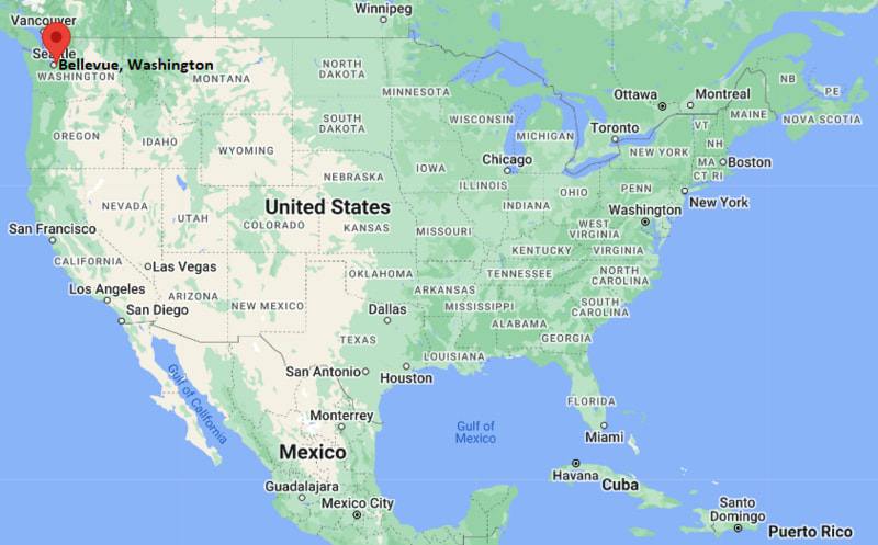
Bellevue Map, Washington, USA
Where is Bellevue?: The Google Map showing the location of Bellevue in the U.S. state of Washington.
Where is Bellevue Located?
Bellevue is a city located in the King County of Washington, United States. Bellevue lies at approximately 47.6199 Degrees North latitude and -122.207 Degrees West longitude. According to the 2020 U.S. Census, the population of Bellevue city is 151,854 people and the city has a total area of 37.504 sq mi. The city has numerous parks and recreational facilities.
Most Viewed US Maps
| USA Sttae Map | USA Region Map | USA Road Map |
| USA County Map | Where is USA in World Map? | US ZIP Code Map |
| USA Time Zones Map | US State and Capitals Map | USA Physical Map |
Find 4,400+ U.S. Cities by State - Explore Their Locations and Get Detailed Information
Bellevue, Washington Quick Facts
| Fact | Details |
|---|---|
| City | Bellevue |
| County | King County |
| State | Washington |
| State Capital | Olympia |
| Country | United States |
| US Region | West |
| Latitude | 47.6199 N |
| Longitude | -122.207 W |
| Elevation | 85 ft (26 m) |
| Land Area | 31.97 sq mi |
| Water Area | 2.46 sq mi |
| Total Area | 37.504 sq mi |
| Population (Census 2020) | 151,854 |
| Population Density | Approximately 4,750 per sq mi |
| ZIP Codes | 98004, 98005, 98006, 98007, 98008, 98009, 98015 |
| Area Code | 425 |
| Time Zone Standard | Pacific Standard Time (PST, UTC-8) |
| Time Zone Daylight | Pacific Daylight Time (PDT, UTC-7) |
| Currency | United States Dollar (USD) |
| FIPS Code | 53-05210 |
| Congressional District | Washington's 9th Congressional District |
Nearby Cities to Bellevue, Washington
- Mercer Island, Washington - 5 mi West
- Kirkland, Washington - 6 mi North
- Redmond, Washington - 8 mi Northeast
- Seattle, Washington - 10 mi West
- Newcastle, Washington - 7 mi South
- Renton, Washington - 10 mi South
- Issaquah, Washington - 11 mi Southeast
- Sammamish, Washington - 12 mi East
- Bothell, Washington - 15 mi North
- Kent, Washington - 20 mi South
Bellevue, Washington Climate and Weather Overview
| Month | Avg High (°F) | Avg Low (°F) | Avg Rainfall (in) |
|---|---|---|---|
| January | 47 | 37 | 5.5 |
| April | 59 | 42 | 2.8 |
| July | 78 | 57 | 0.8 |
| October | 62 | 47 | 3.7 |
| Annual | 62 | 46 | 41.0 |
| Climate Attribute | Details |
|---|---|
| Climate Classification | Warm-Summer Mediterranean (Köppen Csb) |
| Annual Rainfall | Approximately 41 inches |
| Annual Sunshine Days | About 155 days |
| Hurricane/Tornado Risk | Very Low - Occasional windstorms and winter weather events |
| Snowfall | Approximately 6 inches annually |
Driving Distances from Bellevue, Washington
| City | State | Distance (mi) | Approx. Drive Time |
|---|---|---|---|
| Mercer Island | Washington | 5 | 10 min |
| Kirkland | Washington | 6 | 12 min |
| Redmond | Washington | 8 | 15 min |
| Seattle | Washington | 10 | 20 min |
| Newcastle | Washington | 7 | 15 min |
| Renton | Washington | 10 | 20 min |
| Issaquah | Washington | 11 | 20 min |
| Sammamish | Washington | 12 | 25 min |
| Bothell | Washington | 15 | 25 min |
| Kent | Washington | 20 | 30 min |
Transportation and Connectivity in Bellevue, Washington
| Transportation | Details |
|---|---|
| Airport Name | Seattle-Tacoma International Airport |
| IATA Code | SEA |
| Port | Port of Seattle (nearby) |
| Major Highways | Interstate 405, Interstate 90, State Route 520, State Route 900 |
| Train/Amtrak Service | Nearest Amtrak station at Seattle King Street Station; Sound Transit Link light rail serves Bellevue |
| Local Bus/Transit Service | King County Metro, Sound Transit buses and Link Light Rail |
- Interstate 405 - Main north-south freeway connecting Bellevue with Renton, Kirkland, Bothell and Lynnwood.
- Interstate 90 - Crosses Lake Washington and links Bellevue with Seattle, Issaquah and eastern Washington.
- State Route 520 - Provides a direct connection between Bellevue, Redmond and Seattle via the Evergreen Point Floating Bridge.
- State Route 900 - Connects Bellevue with Newcastle, Renton and surrounding communities in south King County.
Key Landmarks and Places to Visit in Bellevue, Washington
| Landmark | Type |
|---|---|
| Bellevue Downtown Park | City Park |
| Bellevue Botanical Garden | Botanical Garden |
| Meydenbauer Beach Park | Beach Park |
| Bellevue Arts Museum | Museum |
| Kelsey Creek Farm Park | Farm Park |
| Mercer Slough Nature Park | Nature Preserve |
| The Bellevue Collection | Shopping District |
| Crossroads Park | Community Park |
| Wilburton Hill Park | City Park |
| KidsQuest Children's Museum | Children's Museum |
Colleges and Universities in Bellevue, Washington
| Institution | Type | Level | Notable For |
|---|---|---|---|
| Bellevue College | Public | Community College | Transfer and workforce education |
| City University of Seattle - Bellevue | Private | University | Professional and graduate programs |
| Northwest University | Private | University | Liberal arts and business |
| University of Washington | Public | University | Research and engineering |
| Seattle University | Private | University | Business and law |
| Lake Washington Institute of Technology | Public | Technical College | Career and technical education |
Waterbodies in Bellevue, Washington
Lake Washington, Lake Sammamish, Mercer Slough, Kelsey Creek, Coal Creek, Phantom Lake, Larsen Lake, Meydenbauer Bay, Lake Boren, Sammamish River.
Golf Courses in Bellevue, Washington
Bellevue Golf Course, Glendale Country Club, The Golf Club at Newcastle, Sahalee Country Club, Willows Run Golf Complex, Overlake Golf & Country Club, Jefferson Park Golf Course, Broadmoor Golf Club.
Bellevue, Washington - Key Historical Facts
- Bellevue was first settled in the 1860s and developed as a farming and logging community on the eastern shore of Lake Washington.
- The opening of floating bridges across Lake Washington helped transform Bellevue into a major suburban center after World War II.
- The city experienced rapid growth during the 1980s and 1990s as technology companies expanded across the Seattle metropolitan area.
- Bellevue became a regional business hub with corporate offices, shopping centers and high-rise development in its downtown district.
- Its strong economy has been supported by major employers in technology, healthcare, finance and retail.
- Today, Bellevue is one of Washington's largest cities, known for its parks, thriving downtown, highly rated schools and innovation-driven economy.
References
Washington Maps and Info
- Where is Auburn
- Where is Bellevue
- Where is Bellingham
- Where is Bothell
- Where is Bremerton
- Where is Burien
- Where is Camas
- Where is Edmonds
- Where is Everett
- Where is Federal Way
- Where is Frederickson
- Where is Graham
- Where is Issaquah
- Where is Kennewick
- Where is Kent
- Where is Kirkland
- Where is Lacey
- Where is Lake Stevens
- Where is Lakewood
- Where is Longview
- Where is Lynnwood
- Where is Maple Valley
- Where is Marysville
- Where is Mill Creek East
- Where is Mount Vernon
- Where is Olympia
- Where is Orchards
- Where is Parkland
- Where is Pasco
- Where is Pullman
- Where is Puyallup
- Where is Redmond
- Where is Renton
- Where is Richland
- Where is Sammamish
- Where is SeaTac
- Where is Shoreline
- Where is South Hill
- Where is Spanaway
- Where is Spokane Valley
- Where is Tacoma
- Where is Tumwater
- Where is University Place
- Where is Vancouver
- Where is Walla Walla
- Where is Wenatchee
- Where is Yakima