
Where is SeaTac Located? - SeaTac is a city located in the King County of Washington, United States. SeaTac lies between 31.8456816 Degrees North latitudes and 102.3676431 Degrees West longitudes.
Location Map of SeaTac, Washington
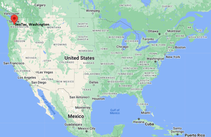
SeaTac Map, Washington, USA
Where is SeaTac?: The Google Map showing the location of SeaTac in the U.S. state of Washington.
Where is SeaTac Located?
SeaTac is a city located in the King County of Washington, United States. SeaTac lies between 31.8456816 Degrees North latitudes and 102.3676431 Degrees West longitudes. According to 2020 U.S.census, the population of SeaTac city is 31454 people and the city has a total area of 10.06 sq mi. The city has numerous parks and recreational facilities.
Most Viewed US Maps
| USA Sttae Map | USA Region Map | USA Road Map |
| USA County Map | Where is USA in World Map? | US ZIP Code Map |
| USA Time Zones Map | US State and Capitals Map | USA Physical Map |
Find 4,400+ U.S. Cities by State - Explore Their Locations and Get Detailed Information
SeaTac, Washington Quick Facts
| Attribute | Details |
|---|---|
| City | SeaTac |
| County | King County |
| State | Washington |
| State Capital | Olympia |
| US Region | Western United States |
| Latitude | 47.4414° N |
| Longitude | 122.2931° W |
| Elevation | 269 ft (82 m) |
| Land Area (sq mi) | 10.06 |
| Water Area (sq mi) | 0.18 |
| Total Area (sq mi) | 10.24 |
| Population (2020 Census) | 31,454 |
| Population Density (per sq mi) | 3,125.4 |
| ZIP Codes | 98148, 98158, 98168, 98188, 98198 |
| Area Code | 206 |
| Time Zone Standard | Pacific Standard Time (PST), UTC−8 |
| Time Zone Daylight | Pacific Daylight Time (PDT), UTC−7 |
| Currency | United States Dollar (USD) |
| FIPS Code | 5362288 |
| Congressional District | 9th Congressional District |
Transportation and Connectivity in SeaTac
| Transportation Feature | Details |
|---|---|
| Airport Name | Seattle-Tacoma International Airport |
| IATA Code | SEA |
| Port | Port of Seattle |
| Major Highways | Interstate 5, Interstate 405, Washington State Route 518, Washington State Route 509, and Washington State Route 99 |
| Train/Amtrak Service | SeaTac/Airport Station provides Link light rail service; Amtrak Cascades and Coast Starlight service is available at nearby Tukwila and Seattle stations. |
| Local Bus/Transit Service | King County Metro and Sound Transit provide local and regional bus service, while Sound Transit Link light rail connects SeaTac with Seattle and other communities. |
- Interstate 5 runs north-south through the region and connects SeaTac with Seattle, Tacoma, Olympia, and other major cities in western Washington.
- Interstate 405 provides an alternate north-south route east of SeaTac and connects the region with Renton, Bellevue, and the Eastside.
- Washington State Route 518 connects SeaTac with Burien and Interstate 5, providing access to the western parts of the region.
- Washington State Route 509 provides a north-south connection toward Burien, Seattle, and the industrial areas along the Duwamish River.
- Washington State Route 99 provides a local and regional connection between SeaTac, Tukwila, and communities in the Seattle metropolitan area.
Top Places to Visit in SeaTac, Washington
| Landmark Name | Type |
|---|---|
| Angle Lake Park | Park |
| Highline SeaTac Botanical Garden | Botanical Garden |
| North SeaTac Park | Park |
| Riverton Heights Park | Park |
| SeaTac Des Moines Creek Trail | Recreation Trail |
| Valley Ridge Park | Park |
| Grandview Off-Leash Dog Park | Dog Park |
| Bow Lake | Lake |
| Angle Lake | Lake |
| Seattle-Tacoma International Airport | Airport |
Driving Distances from SeaTac, Washington to Nearby Cities
| City | State | Distance (mi) | Approx. Drive Time |
|---|---|---|---|
| Tukwila | Washington | 4 | 10 min |
| Burien | Washington | 5 | 10 min |
| Des Moines | Washington | 7 | 15 min |
| Renton | Washington | 8 | 15 min |
| Kent | Washington | 11 | 20 min |
| Seattle | Washington | 15 | 25 min |
| Federal Way | Washington | 15 | 25 min |
| Bellevue | Washington | 19 | 25 min |
| Tacoma | Washington | 28 | 35 min |
| Everett | Washington | 45 | 50 min |
Colleges and Universities in SeaTac, Washington
| Institution Name | Type | Level | Notable For |
|---|---|---|---|
| Highline College | Public | Community College | Career, technical, and transfer programs |
| Green River College | Public | Community College | Career and transfer education |
| Renton Technical College | Public | Community College | Technical and workforce education |
| University of Washington | Public | University | Research and higher education |
Waterbodies in SeaTac, Washington
Angle Lake, Bow Lake, Miller Creek, Des Moines Creek
Golf Courses in SeaTac, Washington
Tyee Valley Golf Course, Foster Golf Links, Riverbend Golf Complex, Maplewood Golf Course
Key Landmarks and Places to Visit in SeaTac, Washington
| Landmark Name | Type |
|---|---|
| Angle Lake Park | Park |
| Highline SeaTac Botanical Garden | Botanical Garden |
| North SeaTac Park | Park |
| SeaTac Des Moines Creek Trail | Recreation Trail |
| Valley Ridge Park | Park |
| Riverton Heights Park | Park |
| Grandview Off-Leash Dog Park | Dog Park |
| Angle Lake | Lake |
| Bow Lake | Lake |
| Seattle-Tacoma International Airport | Airport |
Waterbodies in SeaTac, Washington
Angle Lake, Bow Lake, Miller Creek, Des Moines Creek
Golf Courses in SeaTac, Washington
Tyee Valley Golf Course, Foster Golf Links, Riverbend Golf Complex, Maplewood Golf Course
SeaTac, Washington — Key Historical Facts
- SeaTac was incorporated as a city in 1990 after residents sought a separate municipal government for the area surrounding Seattle-Tacoma International Airport.
- The city's name combines the names of Seattle and Tacoma, the two major cities connected by the regional airport.
- Seattle-Tacoma International Airport has played a major role in shaping SeaTac's economy and development since its opening in 1944.
- SeaTac grew from several unincorporated communities that developed around farms, transportation routes, and the airport.
- Angle Lake and the surrounding natural areas remain important recreational features within the city's developed landscape.
References
- City of SeaTac Official Website
- King County Government
- U.S. Census Bureau
- Seattle-Tacoma International Airport — Port of Seattle
- Highline College
- Green River College
Washington Maps and Info
- Where is Auburn
- Where is Bellevue
- Where is Bellingham
- Where is Bothell
- Where is Bremerton
- Where is Burien
- Where is Camas
- Where is Edmonds
- Where is Everett
- Where is Federal Way
- Where is Frederickson
- Where is Graham
- Where is Issaquah
- Where is Kennewick
- Where is Kent
- Where is Kirkland
- Where is Lacey
- Where is Lake Stevens
- Where is Lakewood
- Where is Longview
- Where is Lynnwood
- Where is Maple Valley
- Where is Marysville
- Where is Mill Creek East
- Where is Mount Vernon
- Where is Olympia
- Where is Orchards
- Where is Parkland
- Where is Pasco
- Where is Pullman
- Where is Puyallup
- Where is Redmond
- Where is Renton
- Where is Richland
- Where is Sammamish
- Where is SeaTac
- Where is Shoreline
- Where is South Hill
- Where is Spanaway
- Where is Spokane Valley
- Where is Tacoma
- Where is Tumwater
- Where is University Place
- Where is Vancouver
- Where is Walla Walla
- Where is Wenatchee
- Where is Yakima