
Where is Bellingham Located? - Bellingham is a city located in the Whatcom County of Washington, United States. Bellingham lies between 48.74896 Degrees North latitudes and -122.489 Degrees West longitudes.
Location Map of Bellingham, Washington
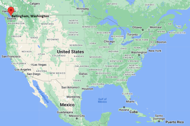
Bellingham Map, Washington, USA
Where is Bellingham?: The Google Map showing the location of Bellingham in the U.S. state of Washington.
Where is Bellingham Located?
Bellingham is a city located in the Whatcom County of Washington, United States. Bellingham lies at approximately 48.74896 Degrees North latitude and -122.489 Degrees West longitude. According to the 2020 U.S. Census, the population of Bellingham city is 91,482 people and the city has a total area of 30.069 sq mi. The city has numerous parks and recreational facilities.
Most Viewed US Maps
| USA Sttae Map | USA Region Map | USA Road Map |
| USA County Map | Where is USA in World Map? | US ZIP Code Map |
| USA Time Zones Map | US State and Capitals Map | USA Physical Map |
Find 4,400+ U.S. Cities by State - Explore Their Locations and Get Detailed Information
Bellingham, Washington Quick Facts
| Fact | Details |
|---|---|
| City | Bellingham |
| County | Whatcom County |
| State | Washington |
| State Capital | Olympia |
| Country | United States |
| US Region | West |
| Latitude | 48.74896 N |
| Longitude | -122.489 W |
| Elevation | 89 ft (27 m) |
| Land Area | 30.53 sq mi |
| Water Area | 2.79 sq mi |
| Total Area | 30.069 sq mi |
| Population (Census 2020) | 92,289 |
| Population Density | Approximately 3,023 per sq mi |
| ZIP Codes | 98225, 98226, 98227, 98228, 98229 |
| Area Code | 360 |
| Time Zone Standard | Pacific Standard Time (PST, UTC-8) |
| Time Zone Daylight | Pacific Daylight Time (PDT, UTC-7) |
| Currency | United States Dollar (USD) |
| FIPS Code | 53-05280 |
| Congressional District | Washington's 2nd Congressional District |
Nearby Cities to Bellingham, Washington
- Ferndale, Washington - 9 mi North
- Lynden, Washington - 15 mi Northeast
- Blaine, Washington - 22 mi North
- Everson, Washington - 18 mi East
- Nooksack, Washington - 21 mi East
- Mount Vernon, Washington - 31 mi South
- Burlington, Washington - 33 mi South
- Anacortes, Washington - 43 mi Southwest
- Sedro-Woolley, Washington - 27 mi Southeast
- Surrey, British Columbia - 36 mi North
Bellingham, Washington Climate and Weather Overview
| Month | Avg High (°F) | Avg Low (°F) | Avg Rainfall (in) |
|---|---|---|---|
| January | 45 | 34 | 5.5 |
| April | 57 | 40 | 2.8 |
| July | 73 | 53 | 1.0 |
| October | 58 | 45 | 4.4 |
| Annual | 58 | 43 | 34.9 |
| Climate Attribute | Details |
|---|---|
| Climate Classification | Warm-Summer Mediterranean (Köppen Csb) |
| Annual Rainfall | Approximately 35 inches |
| Annual Sunshine Days | About 157 days |
| Hurricane/Tornado Risk | Very Low - Coastal windstorms and winter weather are the primary hazards |
| Snowfall | Approximately 9 inches annually |
Driving Distances from Bellingham, Washington
| City | State | Distance (mi) | Approx. Drive Time |
|---|---|---|---|
| Ferndale | Washington | 9 | 12 min |
| Lynden | Washington | 15 | 20 min |
| Everson | Washington | 18 | 25 min |
| Nooksack | Washington | 21 | 30 min |
| Blaine | Washington | 22 | 25 min |
| Sedro-Woolley | Washington | 27 | 35 min |
| Mount Vernon | Washington | 31 | 40 min |
| Burlington | Washington | 33 | 40 min |
| Anacortes | Washington | 43 | 55 min |
| Seattle | Washington | 90 | 1 hr 40 min |
Transportation and Connectivity in Bellingham, Washington
| Transportation | Details |
|---|---|
| Airport Name | Bellingham International Airport |
| IATA Code | BLI |
| Port | Port of Bellingham |
| Major Highways | Interstate 5, State Route 539, State Route 542, State Route 11 |
| Train/Amtrak Service | Amtrak Cascades at Fairhaven Station |
| Local Bus/Transit Service | Whatcom Transportation Authority (WTA) |
- Interstate 5 - Main north-south interstate connecting Bellingham with Seattle, Vancouver and the Canadian border.
- State Route 539 - Links Bellingham with Lynden and the Sumas border crossing.
- State Route 542 - Scenic highway connecting the city with Mount Baker Ski Area and the Mount Baker Highway corridor.
- State Route 11 - Also known as Chuckanut Drive, this scenic coastal route connects Bellingham with Burlington through Chuckanut Bay.
Key Landmarks and Places to Visit in Bellingham, Washington
| Landmark | Type |
|---|---|
| Whatcom Falls Park | City Park |
| Fairhaven Historic District | Historic District |
| SPARK Museum of Electrical Invention | Museum |
| Marine Life Center | Marine Education Center |
| Boulevard Park | Waterfront Park |
| Lake Padden Park | Recreation Park |
| Bellingham Cruise Terminal | Transportation Hub |
| Sehome Hill Arboretum | Nature Preserve |
| Mount Baker Theatre | Performing Arts Venue |
| Larrabee State Park | State Park |
Colleges and Universities in Bellingham, Washington
| Institution | Type | Level | Notable For |
|---|---|---|---|
| Western Washington University | Public | University | Environmental studies and liberal arts |
| Whatcom Community College | Public | Community College | Transfer and workforce education |
| Bellingham Technical College | Public | Technical College | Skilled trades and technology |
| Northwest Indian College | Public Tribal | College | Native American education |
| Charter College - Bellingham | Private | Career College | Healthcare and business programs |
| University of Washington (Seattle) | Public | University | Research and professional education |
Waterbodies in Bellingham, Washington
Bellingham Bay, Lake Whatcom, Lake Padden, Whatcom Creek, Squalicum Creek, Chuckanut Bay, Samish Bay, Nooksack River, Lake Samish, Puget Sound.
Golf Courses in Bellingham, Washington
Lake Padden Golf Course, North Bellingham Golf Course, Shuksan Golf Club, Sudden Valley Golf Course, Loomis Trail Golf Club, Semiahmoo Golf & Country Club, Avalon Golf Links, Raspberry Ridge Golf Course.
Bellingham, Washington - Key Historical Facts
- Bellingham was incorporated in 1903 after the communities of Whatcom, Fairhaven, Sehome and Bellingham merged into one city.
- The city's early economy was built on coal mining, fishing, timber and maritime trade along Bellingham Bay.
- Its deep-water harbor helped establish Bellingham as an important shipping and industrial center in northwest Washington.
- Western Washington University has played a major role in the city's cultural, educational and economic development since the late nineteenth century.
- Bellingham has grown into a popular destination for outdoor recreation because of its proximity to Mount Baker, the San Juan Islands and Puget Sound.
- Today, the city is recognized for its waterfront redevelopment, vibrant arts scene, higher education institutions and easy access to both Seattle and Vancouver, British Columbia.
References
Washington Maps and Info
- Where is Auburn
- Where is Bellevue
- Where is Bellingham
- Where is Bothell
- Where is Bremerton
- Where is Burien
- Where is Camas
- Where is Edmonds
- Where is Everett
- Where is Federal Way
- Where is Frederickson
- Where is Graham
- Where is Issaquah
- Where is Kennewick
- Where is Kent
- Where is Kirkland
- Where is Lacey
- Where is Lake Stevens
- Where is Lakewood
- Where is Longview
- Where is Lynnwood
- Where is Maple Valley
- Where is Marysville
- Where is Mill Creek East
- Where is Mount Vernon
- Where is Olympia
- Where is Orchards
- Where is Parkland
- Where is Pasco
- Where is Pullman
- Where is Puyallup
- Where is Redmond
- Where is Renton
- Where is Richland
- Where is Sammamish
- Where is SeaTac
- Where is Shoreline
- Where is South Hill
- Where is Spanaway
- Where is Spokane Valley
- Where is Tacoma
- Where is Tumwater
- Where is University Place
- Where is Vancouver
- Where is Walla Walla
- Where is Wenatchee
- Where is Yakima