
Where is Kennewick Located? - Kennewick is a city located in the Benton County of Washington, United States. Kennewick lies between 40.5070087 Degrees North latitudes and 111.4133234 Degrees West longitudes.
Location Map of Kennewick, Washington
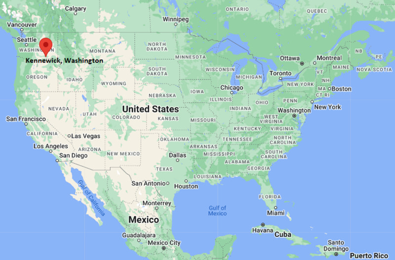
Kennewick Map, Washington, USA
Where is Kennewick?: The Google Map showing the location of Kennewick in the U.S. state of Washington.
Where is Kennewick Located?
Kennewick is a city located in the Benton County of Washington, United States. Kennewick lies between 40.5070087 Degrees North latitudes and 111.4133234 Degrees West longitudes. According to 2020 U.S.census, the population of Kennewick city is 83921 people and the city has a total area of 27.45 sq mi. The city has numerous parks and recreational facilities.
Most Viewed US Maps
| USA Sttae Map | USA Region Map | USA Road Map |
| USA County Map | Where is USA in World Map? | US ZIP Code Map |
| USA Time Zones Map | US State and Capitals Map | USA Physical Map |
Find 4,400+ U.S. Cities by State - Explore Their Locations and Get Detailed Information
Kennewick, Washington Quick Facts
| Property | Information |
|---|---|
| City | Kennewick |
| County | Benton County |
| State | Washington |
| State Capital | Olympia |
| US Region | Pacific Northwest |
| Latitude | 46.2112° N |
| Longitude | 119.1372° W |
| Elevation | 410 ft (125 m) |
| Land Area | 28.36 sq mi |
| Water Area | 0.61 sq mi |
| Total Area | 28.97 sq mi |
| Population (latest Census year) | 83,921 (2020 Census) |
| Population Density | Approximately 2,959 per sq mi |
| ZIP Code | 99336, 99337, 99338 |
| Area Code | 509 |
| Time Zone Standard | Pacific Standard Time (PST, UTC−8) |
| Time Zone Daylight | Pacific Daylight Time (PDT, UTC−7) |
| Currency | US Dollar (USD) |
| FIPS Code | 53-35275 |
| Congressional District | Washington's 4th Congressional District |
Nearby Cities to Kennewick, Washington
- Richland, Washington - Northwest - 9 mi
- Pasco, Washington - North - 10 mi
- West Richland, Washington - Northwest - 12 mi
- Burbank, Washington - East - 14 mi
- Benton City, Washington - West - 17 mi
- Prosser, Washington - West - 31 mi
- Hermiston, Oregon - Southeast - 33 mi
- Walla Walla, Washington - East - 46 mi
- Sunnyside, Washington - Northwest - 50 mi
- Yakima, Washington - Northwest - 79 mi
Driving Distances from Kennewick, Washington
| City | State | Distance (mi) | Approx. Drive Time |
|---|---|---|---|
| Richland | Washington | 9 | 15 minutes |
| Pasco | Washington | 10 | 15 minutes |
| West Richland | Washington | 12 | 20 minutes |
| Burbank | Washington | 14 | 20 minutes |
| Benton City | Washington | 17 | 25 minutes |
| Prosser | Washington | 31 | 35 minutes |
| Hermiston | Oregon | 33 | 40 minutes |
| Walla Walla | Washington | 46 | 55 minutes |
| Sunnyside | Washington | 50 | 1 hour |
| Yakima | Washington | 79 | 1 hour 20 minutes |
Transportation and Connectivity in Kennewick, Washington
| Transportation | Details |
|---|---|
| Airport Name | Tri-Cities Airport |
| IATA Code | PSC |
| Port | Port of Kennewick |
| Major Highways | Interstate 82, U.S. Route 395, State Route 240, State Route 397 |
| Train/Amtrak Service | Nearest Amtrak station at Pasco Intermodal Station |
| Local Bus/Transit Service | Ben Franklin Transit |
- Interstate 82 connects Kennewick with Yakima, Ellensburg, and Interstate 90, while U.S. Route 395 links the city to Oregon and eastern Washington.
- The Tri-Cities Airport in nearby Pasco provides scheduled passenger flights to major destinations throughout the western United States.
- Ben Franklin Transit operates local and regional bus services across Kennewick, Pasco, Richland, and neighboring communities.
- Amtrak passenger rail service is available at Pasco Intermodal Station via the Empire Builder route.
- The Port of Kennewick supports river transportation, recreation, commercial development, and waterfront activities along the Columbia River.
What are top Places to Visit in Kennewick, Washington
| Landmark Name | Type |
|---|---|
| Columbia Park | Regional Park |
| Sacajawea Heritage Trail | Walking & Cycling Trail |
| Clover Island | Riverfront Attraction |
| Three Rivers Convention Center | Convention Center |
| Toyota Center | Sports & Entertainment Arena |
| East Benton County Historical Museum | History Museum |
| Candy Mountain Preserve | Nature Preserve |
| Badger Mountain Centennial Preserve | Nature Area |
| Zintel Canyon Park | Community Park |
| Columbia Center Mall | Shopping Center |
Colleges and Universities in Kennewick, Washington
| Institution Name | Type | Level | Notable For |
|---|---|---|---|
| Washington State University Tri-Cities | Public | University | Engineering, business, education, nursing, and research programs |
| Columbia Basin College | Public | Community College | Associate degrees, workforce training, STEM, and transfer programs |
| Pacific Northwest University of Health Sciences | Private | Graduate University | Osteopathic medicine, physical therapy, and health sciences |
| Heritage University – Tri-Cities Center | Private | University | Teacher education, business, social work, and healthcare programs |
| Eastern Washington University – Tri-Cities Center | Public | University | Business, education, public administration, and professional studies |
Waterbodies in Kennewick, Washington
Columbia River, Yakima River, Snake River (nearby), McNary Pool, Columbia Park Marina, Clover Island Marina, Bateman Island, Hood Park.
Golf Courses in Kennewick, Washington
Canyon Lakes Golf Course, Columbia Point Golf Course, Sun Willows Golf Course, Horn Rapids Golf Club, Tri-City Country Club, Buckskin Golf Club.
Kennewick, Washington — Key Historical Facts
- Kennewick was incorporated in 1904 after developing as an agricultural settlement along the Columbia River supported by irrigation and railroad transportation.
- The city's economy expanded significantly during the 1940s with the establishment of the nearby Hanford Site, which became a major center for nuclear research and production.
- Kennewick, Richland, and Pasco collectively became known as the Tri-Cities, forming one of southeastern Washington's principal economic and population centers.
- The discovery of the prehistoric Kennewick Man in 1996 along the Columbia River brought international attention to the city's archaeological significance.
- Today, Kennewick is recognized for its healthcare, research, wine industry, outdoor recreation, and growing technology and manufacturing sectors.
References
- City of Kennewick
- U.S. Census Bureau
- Washington State University Tri-Cities
- Port of Kennewick
- Visit Tri-Cities Washington
Washington Maps and Info
- Where is Auburn
- Where is Bellevue
- Where is Bellingham
- Where is Bothell
- Where is Bremerton
- Where is Burien
- Where is Camas
- Where is Edmonds
- Where is Everett
- Where is Federal Way
- Where is Frederickson
- Where is Graham
- Where is Issaquah
- Where is Kennewick
- Where is Kent
- Where is Kirkland
- Where is Lacey
- Where is Lake Stevens
- Where is Lakewood
- Where is Longview
- Where is Lynnwood
- Where is Maple Valley
- Where is Marysville
- Where is Mill Creek East
- Where is Mount Vernon
- Where is Olympia
- Where is Orchards
- Where is Parkland
- Where is Pasco
- Where is Pullman
- Where is Puyallup
- Where is Redmond
- Where is Renton
- Where is Richland
- Where is Sammamish
- Where is SeaTac
- Where is Shoreline
- Where is South Hill
- Where is Spanaway
- Where is Spokane Valley
- Where is Tacoma
- Where is Tumwater
- Where is University Place
- Where is Vancouver
- Where is Walla Walla
- Where is Wenatchee
- Where is Yakima