
Where is Everett Located? - Everett is a city located in the Snohomish County of Washington, United States. Everett lies between 40.8485564 Degrees North latitudes and 111.9068824 Degrees West longitudes.
Location Map of Everett, Washington
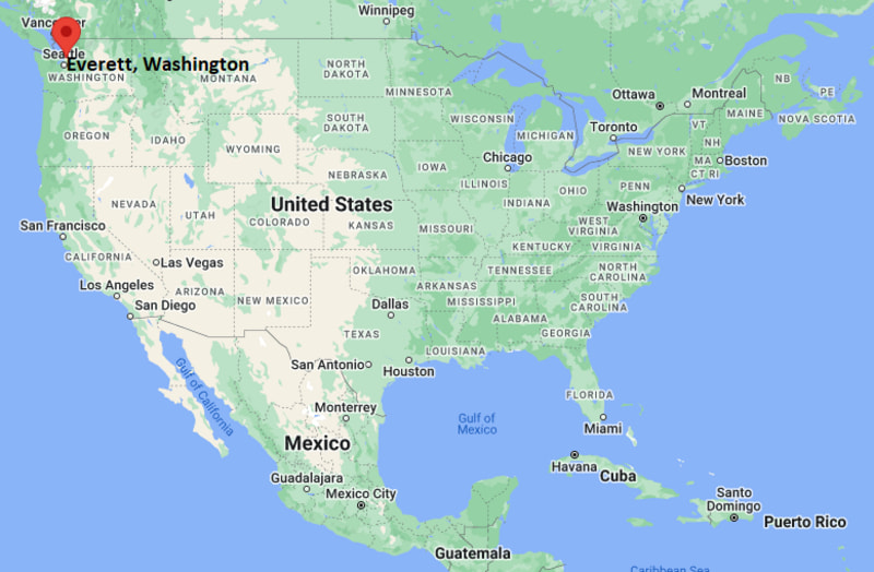
Everett Map, Washington, USA
Where is Everett?: The Google Map showing the location of Everett in the U.S. state of Washington.
Where is Everett Located?
Everett is a city located in the Snohomish County of Washington, United States. Everett lies between 40.8485564 Degrees North latitudes and 111.9068824 Degrees West longitudes. According to 2020 U.S.census, the population of Everett city is 110629 people and the city has a total area of 33.2 sq mi. The city has numerous parks and recreational facilities.
Most Viewed US Maps
| USA Sttae Map | USA Region Map | USA Road Map |
| USA County Map | Where is USA in World Map? | US ZIP Code Map |
| USA Time Zones Map | US State and Capitals Map | USA Physical Map |
Find 4,400+ U.S. Cities by State - Explore Their Locations and Get Detailed Information
Everett, Washington Quick Facts
| Property | Details |
|---|---|
| City | Everett |
| County | Snohomish County |
| State | Washington |
| State Capital | Olympia |
| US Region | West |
| Latitude | 47.9780°N |
| Longitude | 122.2021°W |
| Elevation | ~30 ft (9 m) |
| Land Area | Approx. 47.9 sq mi |
| Water Area | Approx. 5.2 sq mi |
| Total Area | Approx. 53.1 sq mi |
| Population (2020 Census) | ~110,000 |
| Population Density | Approximately 2,300 per sq mi |
| ZIP Codes | 98201–98208 |
| Area Code | 425 / 564 |
| Time Zone Standard | Pacific Standard Time (PST), UTC−8 |
| Time Zone Daylight | Pacific Daylight Time (PDT), UTC−7 |
| Currency | US Dollar (USD) |
| FIPS Code | 53-22640 |
| Congressional District | Washington's 2nd Congressional District |
Nearby Cities to Everett, Washington
- Marysville, Washington - North - 10 mi
- Lynnwood, Washington - South - 12 mi
- Bothell, Washington - South - 20 mi
- Seattle, Washington - South - 30 mi
- Mount Vernon, Washington - North - 35 mi
- Bellingham, Washington - North - 85 mi
- Kirkland, Washington - South - 25 mi
- Edmonds, Washington - South - 15 mi
- Arlington, Washington - North - 15 mi
- Snohomish, Washington - East - 10 mi
Everett, Washington Climate and Weather Overview
| Month | Avg High (°F) | Avg Low (°F) | Avg Rainfall (in) |
|---|---|---|---|
| January | 47 | 36 | 5.8 |
| April | 58 | 41 | 2.8 |
| July | 76 | 53 | 1.1 |
| October | 60 | 44 | 3.9 |
| Annual | 59 | 43 | ~37.0 |
| Climate Attribute | Details |
|---|---|
| Climate Classification (Köppen) | Marine west coast (Cfb) |
| Annual Rainfall | About 35–40 inches |
| Summer Conditions | Mild, dry summers with cool nights |
| Winter Conditions | Cool, wet winters with overcast skies |
| Severe Weather Risk | Windstorms, occasional flooding, rare snow events |
Driving Distances from Everett, Washington
| City | State | Distance (mi) | Approx. Drive Time |
|---|---|---|---|
| Seattle | Washington | 30 | 35–50 min |
| Marysville | Washington | 10 | 15 min |
| Lynnwood | Washington | 12 | 20 min |
| Bothell | Washington | 20 | 25–30 min |
| Edmonds | Washington | 15 | 20 min |
| Arlington | Washington | 15 | 20 min |
| Mount Vernon | Washington | 35 | 40–45 min |
| Kirkland | Washington | 25 | 30 min |
| Bellingham | Washington | 85 | 1 hr 20 min |
| Olympia | Washington | 110 | 2 hr |
Transportation and Connectivity in Everett, Washington
| Transportation | Details |
|---|---|
| Airport Name | Seattle-Tacoma International Airport |
| IATA Code | SEA |
| Regional Airport | Paine Field (Snohomish County Airport) |
| Major Highways | I-5, US-2, SR-99 |
| Rail Service | Amtrak Cascades, Sounder commuter rail |
| Local Transit | Everett Transit, Community Transit |
- Everett is a major industrial and maritime city in the Puget Sound region.
- It is home to Boeing’s largest assembly plant in the world.
- The city has a strong waterfront economy including shipping and defense industries.
- Its location on Puget Sound makes it an important transportation and logistics hub.
Places to Visit in Everett, Washington
| Landmark Name | Type |
|---|---|
| Imagine Children's Museum | Children’s Museum |
| Jetty Island | Island Beach & Recreation Area |
| Everett Marina | Marina |
| Funko Headquarters | Pop Culture Attraction |
| Schack Art Center | Art Gallery |
| Flying Heritage & Combat Armor Museum | Military Museum |
| Hewitt Avenue Historic District | Historic District |
| Howarth Park | Waterfront Park |
| Forest Park | City Park |
| Howarth Beach | Beach |
Colleges and Universities in Everett, Washington
| Institution Name | Type | Level | Notable For |
|---|---|---|---|
| Everett Community College | Public | Community College | Transfer programs, aviation maintenance |
| University of Washington (Seattle campus - regional access) | Public | University | Research, engineering, medicine |
| Washington State University (regional programs) | Public | University | Agriculture, engineering, sciences |
| Western Washington University (regional access) | Public | University | Business, education, environmental studies |
| Edmonds College (nearby) | Public | Community College | Healthcare and technical training |
| Everett Public Schools | Public | K–12 District | Primary and secondary education system |
| Mukilteo School District (nearby) | Public | K–12 District | Regional suburban school system |
| Northshore School District (nearby) | Public | K–12 District | High-performing suburban schools |
Waterbodies in Everett, Washington
Puget Sound, Snohomish River, Port Gardner Bay, Possession Sound, Steamboat Slough, Howarth Park shoreline, Jetty Island waters, Spencer Island wetlands
Golf Courses in Everett, Washington
Everett Golf & Country Club, Legion Memorial Golf Course, Walter E. Hall Golf Course, Harbour Pointe Golf Club (nearby), Battle Creek Golf Course, Nile Shrine Golf Course, Kayak Point Golf Course (regional), Jackson Park Golf Course (Seattle area)
Everett, Washington — Key Historical Facts
- Everett was incorporated in 1893 during a major Pacific Northwest industrial expansion.
- The city was built as a planned industrial center supported by timber and shipping industries.
- Early growth was driven by mills, railroads, and waterfront trade.
- In the 20th century, aerospace manufacturing became central to the local economy.
- Boeing established major facilities that transformed Everett into a global aerospace hub.
- Today, Everett blends maritime industry, aerospace, and growing tech and service sectors.
References
Washington Maps and Info
- Where is Auburn
- Where is Bellevue
- Where is Bellingham
- Where is Bothell
- Where is Bremerton
- Where is Burien
- Where is Camas
- Where is Edmonds
- Where is Everett
- Where is Federal Way
- Where is Frederickson
- Where is Graham
- Where is Issaquah
- Where is Kennewick
- Where is Kent
- Where is Kirkland
- Where is Lacey
- Where is Lake Stevens
- Where is Lakewood
- Where is Longview
- Where is Lynnwood
- Where is Maple Valley
- Where is Marysville
- Where is Mill Creek East
- Where is Mount Vernon
- Where is Olympia
- Where is Orchards
- Where is Parkland
- Where is Pasco
- Where is Pullman
- Where is Puyallup
- Where is Redmond
- Where is Renton
- Where is Richland
- Where is Sammamish
- Where is SeaTac
- Where is Shoreline
- Where is South Hill
- Where is Spanaway
- Where is Spokane Valley
- Where is Tacoma
- Where is Tumwater
- Where is University Place
- Where is Vancouver
- Where is Walla Walla
- Where is Wenatchee
- Where is Yakima