
Where is Bountiful Located? - Bountiful is a city located in the Davis County of Utah, United States. Bountiful lies between 35.9606384 Degrees North latitudes and 83.9207392 Degrees West longitudes.
Location Map of Bountiful, Utah
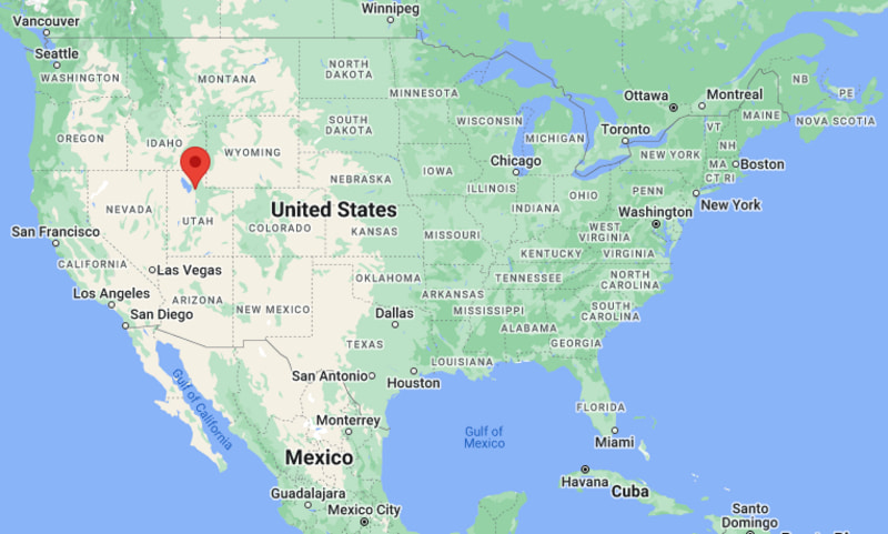
Bountiful Map, Utah, USA
Where is Bountiful?: The Google Map showing the location of Bountiful in the U.S. state of Utah.
Where is Bountiful Located?
Bountiful is a city located in the Davis County of Utah, United States. Bountiful lies between 35.9606384 Degrees North latitudes and 83.9207392 Degrees West longitudes. According to 2020 U.S.census, the population of Bountiful city is 45762 people and the city has a total area of 13.2 sq mi. The city has numerous parks and recreational facilities.
Most Viewed US Maps
| USA Sttae Map | USA Region Map | USA Road Map |
| USA County Map | Where is USA in World Map? | US ZIP Code Map |
| USA Time Zones Map | US State and Capitals Map | USA Physical Map |
Find 4,400+ U.S. Cities by State - Explore Their Locations and Get Detailed Information
Bountiful, Utah Quick Facts
| Fact | Details |
|---|---|
| City | Bountiful |
| County | Davis County |
| State | Utah |
| State Capital | Salt Lake City |
| Country | United States |
| US Region | West |
| Latitude | 40.8894°N |
| Longitude | 111.8808°W |
| Elevation | 4,593 ft (1,400 m) |
| Land Area | 13.30 sq mi |
| Water Area | 0.00 sq mi |
| Total Area | 13.30 sq mi |
| Population (Census 2020) | 45,762 |
| Population Density | Approximately 3,441 per sq mi |
| ZIP Codes | 84010, 84011 |
| Area Code | 385, 801 |
| Time Zone Standard | Mountain Standard Time (MST, UTC-7) |
| Time Zone Daylight | Mountain Daylight Time (MDT, UTC-6) |
| Currency | United States Dollar (USD) |
| FIPS Code | 49-07690 |
| Congressional District | Utah's 1st Congressional District |
Nearby Cities and Towns to Bountiful, Utah
- North Salt Lake, Utah - 4 mi South
- Woods Cross, Utah - 3 mi Southwest
- Centerville, Utah - 4 mi North
- West Bountiful, Utah - 4 mi Northwest
- Farmington, Utah - 9 mi North
- Salt Lake City, Utah - 10 mi South
- Layton, Utah - 18 mi North
- Kaysville, Utah - 14 mi North
- Clearfield, Utah - 22 mi North
- Ogden, Utah - 37 mi North
Bountiful, Utah Climate and Weather Overview
| Month | Avg High (°F) | Avg Low (°F) | Avg Precipitation (in) |
|---|---|---|---|
| January | 38 | 24 | 1.8 |
| April | 61 | 40 | 2.1 |
| July | 91 | 67 | 0.7 |
| October | 67 | 44 | 1.3 |
| Annual | 64 | 44 | 17.2 |
| Climate Attribute | Details |
|---|---|
| Climate Classification | Hot-Summer Mediterranean (Köppen Csa) |
| Annual Precipitation | Approximately 17.2 inches |
| Annual Sunshine Days | About 222 days |
| Severe Weather Risk | Moderate - Winter snowstorms, thunderstorms and occasional strong winds |
| Annual Snowfall | Approximately 48 inches |
Driving Distances from Bountiful, Utah
| City | State | Distance (mi) | Approx. Drive Time |
|---|---|---|---|
| Woods Cross | Utah | 3 | 8 min |
| North Salt Lake | Utah | 4 | 10 min |
| Centerville | Utah | 4 | 10 min |
| West Bountiful | Utah | 4 | 10 min |
| Farmington | Utah | 9 | 15 min |
| Salt Lake City | Utah | 10 | 15 min |
| Kaysville | Utah | 14 | 20 min |
| Layton | Utah | 18 | 25 min |
| Clearfield | Utah | 22 | 30 min |
| Ogden | Utah | 37 | 40 min |
Transportation and Connectivity in Bountiful, Utah
| Transportation | Details |
|---|---|
| Nearest Airport | Salt Lake City International Airport |
| IATA Code | SLC |
| Major Highways | Interstate 15, U.S. Route 89, Legacy Parkway (SR 67) |
| Rail Service | FrontRunner commuter rail available at nearby Woods Cross and Farmington stations |
| Local Transit | Utah Transit Authority (UTA) bus and commuter rail services |
- Interstate 15 is the primary north-south route, providing convenient access to Salt Lake City, Ogden and other Wasatch Front communities.
- U.S. Route 89 and Legacy Parkway offer additional regional connections throughout northern Utah.
- Salt Lake City International Airport, approximately 15 miles southwest, serves domestic and international travelers.
- UTA buses and nearby FrontRunner commuter rail stations provide convenient public transportation throughout the Salt Lake metropolitan area.
Key Landmarks and Places to Visit in Bountiful, Utah
| Landmark | Type |
|---|---|
| Bountiful Utah Temple | Religious Landmark |
| Mueller Park | City Park |
| Bountiful Ridge Golf Club | Golf Course |
| Eaglewood Golf Course | Golf Course |
| South Davis Recreation Center | Recreation Center |
| Bountiful City Park | Community Park |
| Holbrook Visitor Center | Visitor Center |
| Mueller Park Trailhead | Hiking Area |
| Elephant Rock | Natural Landmark |
| Bountiful Historical Museum | Local History Museum |
Colleges and Universities in Bountiful, Utah
| Institution | Type | Level | Notable For |
|---|---|---|---|
| Davis Technical College | Public | Technical College | Career and workforce training |
| University of Utah | Public | Research University | Medicine, engineering, business and research |
| Weber State University | Public | University | Business, health professions and engineering |
| Salt Lake Community College | Public | Community College | Transfer degrees and technical education |
| Western Governors University | Private, Nonprofit | University | Online undergraduate and graduate programs |
| Ensign College | Private | College | Business, technology and professional education |
Waterbodies in Bountiful, Utah
Parley's Creek, Mill Creek, Mueller Park Creek, Farmington Bay, Great Salt Lake, Bountiful Pond, Holbrook Creek, Stone Creek, Barton Creek, Deuel Creek.
Golf Courses in Bountiful, Utah
Bountiful Ridge Golf Club, Eaglewood Golf Course, Lakeside Golf Course, Valley View Golf Course, Oakridge Country Club, Davis Park Golf Course, Glen Eagle Golf Course, Bonneville Golf Course.
Bountiful, Utah - Key Historical Facts
- Bountiful was first settled in 1847 by Mormon pioneers and became one of the earliest permanent communities established in the Utah Territory.
- The city was named "Bountiful" after the fertile land described in the Book of Mormon, reflecting the area's productive farms and orchards.
- Fruit growing, agriculture and livestock raising formed the foundation of the local economy throughout the nineteenth and early twentieth centuries.
- Its location along the Wasatch Front encouraged residential growth as transportation links connected the city with Salt Lake City and surrounding communities.
- The completion of the Bountiful Utah Temple in 1995 made the city an important religious destination for members of The Church of Jesus Christ of Latter-day Saints.
- Today, Bountiful is known for its family-friendly neighborhoods, scenic mountain views, outdoor recreation, quality schools and convenient access to the Salt Lake metropolitan area.
References
Utah Related Maps and Info
| Utah Map | Counties in Utah | Cities in Utah |
| Utah Zipcodes | Airports in Utah | US Zip code Map |
| Utah Area Codes | Utah River Map | - |
- Where is American Fork
- Where is Bluffdale
- Where is Bountiful
- Where is Brigham City
- Where is Cedar City
- Where is Centerville
- Where is Clearfield
- Where is Clinton
- Where is Cottonwood Heights
- Where is Draper
- Where is Eagle Mountain
- Where is Farmington
- Where is Heber
- Where is Herriman
- Where is Highland
- Where is Holladay
- Where is Hurricane
- Where is Kaysville
- Where is Layton
- Where is Lehi
- Where is Logan
- Where is Midvale
- Where is Murray
- Where is North Ogden
- Where is North Salt Lake
- Where is Ogden
- Where is Orem
- Where is Payson
- Where is Pleasant Grove
- Where is Provo
- Where is Riverton
- Where is Roy
- Where is Sandy
- Where is Santaquin
- Where is Saratoga Springs
- Where is South Jordan
- Where is South Ogden
- Where is South Salt Lake
- Where is Spanish Fork
- Where is Springville
- Where is St. George
- Where is Syracuse
- Where is Taylorsville
- Where is Tooele
- Where is Vineyard
- Where is Washington
- Where is West Haven
- Where is West Jordan
- Where is West Valley City